Menifee County deer harvest: Kentucky Telecheck, 2016-17 to 2025-26
Hunters telechecked 218 deer in Menifee County in the 2025-26 season: 194 antlered bucks and 20 does (KDFWR). That is 1.1 deer per square mile of land, 120th of Kentucky's 120 counties by total. The count was 10% below 2024-25 (241). The county is in deer Zone 3.
Data updated October 2026. Harvest: KDFWR Telecheck reports to the 2025-26 season. Zones and seasons: KDFWR's 2026-27 guide.
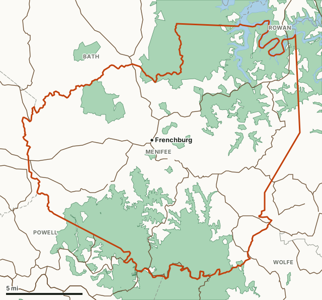
Menifee CountyKDFWR public hunting areasNational forestLake or riverHighwayCounty line
| Deer telechecked, 2025-26 | 218 (194 antlered bucks, 20 does) |
|---|---|
| Per square mile of land | 1.1, 118th of 120 |
| Average, 10 seasons | 197 deer a season |
| Highest season | 292 in 2016-17 |
| Deer zone, 2026-27 | Zone 3 (KDFWR) |
| KDFWR region | Northeast region |
| How the 2025-26 deer were taken | 166 by firearms, 23 by archery, 23 by crossbow and 6 by muzzleloader |
| Land area | 203.5 square miles (Census) |
| Public land mapped here | 2 public hunting areas, 46,782 acres; 115 acres of national forest |
| Towns | Frenchburg |
How many deer are killed in Menifee County each season?
KDFWR has reported Menifee County's deer for 10 seasons. The average was 197 a season; the most was 292 in 2016-17 and the fewest 139 in 2020-21. 2025-26 was 25% below 2016-17.
| Season | Deer telechecked | Antlered bucks | Does | Per square mile | Firearms | Archery and crossbow |
|---|---|---|---|---|---|---|
| 2025-26 | 218 | 194 | 20 | 1.1 | 172 | 46 |
| 2024-25 | 241 | 211 | 27 | 1.2 | 192 | 49 |
| 2023-24 | 181 | 159 | 22 | 0.9 | 138 | 43 |
| 2022-23 | 202 | 176 | 23 | 1 | 159 | 43 |
| 2021-22 | 172 | 153 | 19 | 0.8 | 134 | 38 |
| 2020-21 | 139 | 121 | 16 | 0.7 | 116 | 23 |
| 2019-20 | 162 | 138 | 21 | 0.8 | 140 | 22 |
| 2018-19 | 212 | 181 | 28 | 1 | 184 | 28 |
| 2017-18 | 150 | 124 | 22 | 0.7 | 120 | 30 |
| 2016-17 | 292 | 234 | 47 | 1.4 | 228 | 64 |
Source: KDFWR Harvest Data (Telecheck), deer by county. Firearms adds modern gun and muzzleloader deer. Per square mile uses the county's 203.5 square miles of land (Census).
What are the deer rules in Menifee County for 2026-27?
Menifee County is in Zone 3: Up to four deer. Only one antlerless deer with a firearm or air gun. Only one antlered deer may be taken statewide.
| Season | Dates |
|---|---|
| Archery | September 5, 2026 to January 18, 2027 |
| Youth and senior crossbow | September 5, 2026 to January 18, 2027 |
| Crossbow | September 19, 2026 to January 18, 2027 |
| CWD antlerless season (Zone 1 to 3 counties in the CWD Surveillance Zone) | September 25 to 28, 2026 |
| Youth-only modern firearms | October 10 to 18, 2026 |
| Early muzzleloader | October 17 to 18, 2026 |
| Modern firearms | November 14 to 29, 2026 |
| Late muzzleloader | December 12 to 20, 2026 |
| Free youth weekend | December 26 to 27, 2026 |
Source: 2026-27 Kentucky Hunting and Trapping Guide, page 10; county zones: KDFWR current deer zones. KDFWR's guide notes proposed regulations, still pending when it was printed, that would add antlerless firearm seasons in some counties and on some WMAs (page 11). Check fw.ky.gov for their status.
Where is the public hunting land in Menifee County?
| Area | Acres in Menifee County | Deer on the whole area, 2025-26 |
|---|---|---|
| Daniel Boone National Forest | 43,787 | 1,270 |
| Pioneer Weapons WMA | 2,995 | 5 |
115 acres of national forest lie in the county, measured on the federal maps.
Acres measured by FilledTag on KDFWR public hunting area boundaries, U.S. Forest Service national forest ownership and U.S. Fish and Wildlife Service refuge boundaries.
How does Menifee County compare with its neighbors?
| County | Zone | Deer, 2025-26 | Per square mile | Change since 2016-17 |
|---|---|---|---|---|
| Menifee County | 3 | 218 | 1.1 | -25% |
| Bath County | 2 | 821 | 3 | 19% |
| Montgomery County | 2 | 450 | 2.3 | 22% |
| Morgan County | 2 | 715 | 1.9 | -34% |
| Powell County | 3 | 381 | 2.1 | -2% |
| Rowan County | 2 | 543 | 1.9 | -2% |
| Wolfe County | 3 | 373 | 1.7 | -29% |
Questions hunters ask
How many deer were killed in Menifee County, Kentucky last season?
Hunters telechecked 218 deer in Menifee County in the 2025-26 season: 194 antlered bucks, 4 button bucks and 20 does, by KDFWR's Harvest Data reports.
What deer zone is Menifee County in?
Menifee County is in Zone 3 for 2026-27. Up to four deer. Only one antlerless deer with a firearm or air gun. Only one antlered deer may be taken statewide (KDFWR 2026-27 guide, page 10).
Is there public hunting land in Menifee County?
Yes. KDFWR's map puts Daniel Boone National Forest (43,787 acres in the county) and Pioneer Weapons WMA (2,995 acres in the county) in Menifee County. The county also holds 115 acres of national forest.
Has the deer harvest in Menifee County gone up or down?
From 292 in 2016-17 to 218 in 2025-26, 25% lower. The high in that span was 292 (2016-17) and the low 139 (2020-21).
Get a Kentucky hunt plan when they open
Hunt plans for Kentucky are coming. Join the list and you'll hear first. The first 50 hunters in each new state get their plan free.
Until then, the free FilledTag app for iPhone has a map that works in every state, Kentucky included.
Where these numbers come from
- Deer and elk harvest: KDFWR Harvest Data (Telecheck), deer by county; KDFWR Harvest Data (Telecheck), elk.
- Deer zones and seasons: 2026-27 Kentucky Hunting and Trapping Guide, page 10; KDFWR current deer zones.
- Public land: KDFWR public hunting area boundaries; U.S. Forest Service national forest ownership; U.S. Fish and Wildlife Service refuge boundaries. County land area: U.S. Census Bureau 2024 county boundaries. Highways and towns: U.S. Census Bureau TIGER/Line 2024 roads; U.S. Census Bureau 2024 Gazetteer.
FilledTag is not part of Kentucky Fish and Wildlife. Numbers are copied from KDFWR and the Census Bureau or measured from public maps; nothing here is estimated by FilledTag.
Kentucky hunting Kentucky deer harvest by county Bath County Montgomery County Morgan County Powell County