Kentucky elk hunting unit 5: counties, public land and elk harvest
Elk hunting unit 5 covers 395,584 acres of Kentucky's Elk Management Zone, mostly in Letcher County, Knott County and Perry County, by KDFWR's unit map. 7 public hunting areas with 20,796 acres lie inside it. Hunters telechecked 6 elk in Letcher County, 24 elk in Knott County and 11 elk in Perry County in 2025-26.
Data updated October 2026. Unit boundary: KDFWR's elk hunting unit map. Harvest: KDFWR Telecheck reports to 2025-26.
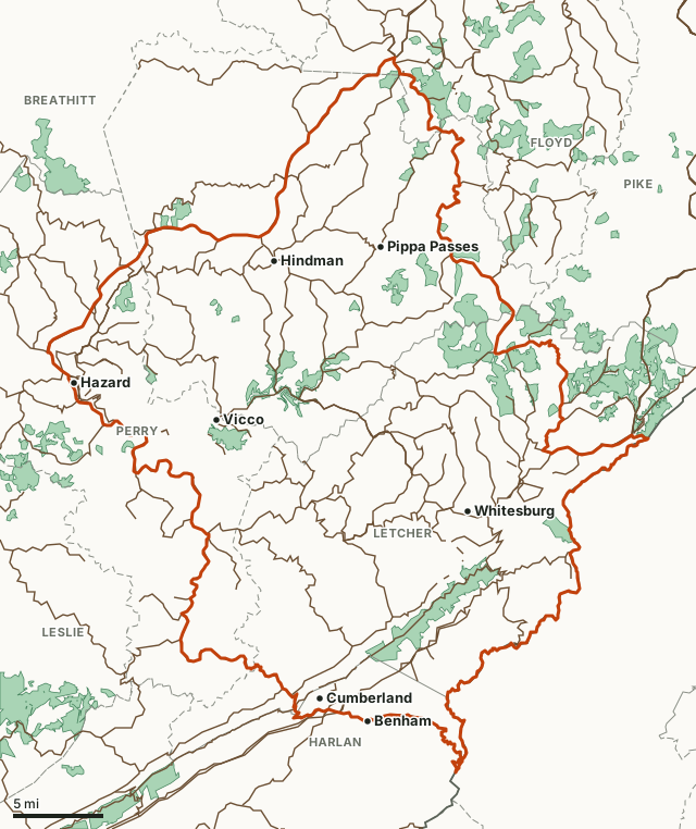
Unit 5KDFWR public hunting areasNational forestLake or riverHighwayCounty line
| Size | 395,584 acres (measured on KDFWR's map) |
|---|---|
| Counties | Letcher County, Knott County, Perry County, Harlan County, Floyd County |
| Public hunting areas inside | 7, 20,796 acres |
| Towns | Hazard, Whitesburg, Cumberland, Hindman, Vicco and Pippa Passes |
| Bull firearms, 2026 | September 26 to 30 and October 3 to 7 |
How many elk are taken in the counties of unit 5?
KDFWR reports elk by county, not by unit, so these are whole-county numbers. A county can lie in more than one unit.
| County | Acres in unit 5 | Elk, 2025-26 | Bulls | Cows | Elk, 2016-17 to 2025-26 |
|---|---|---|---|---|---|
| Letcher County | 179,125 | 6 | 6 | 0 | 116 |
| Knott County | 144,995 | 24 | 19 | 5 | 481 |
| Perry County | 55,708 | 11 | 6 | 5 | 247 |
| Harlan County | 12,286 | 12 | 10 | 2 | 110 |
| Floyd County | 3,319 | 0 | 65 |
Source: KDFWR Harvest Data (Telecheck), elk. Acres measured by FilledTag on KDFWR elk hunting units and the U.S. Census Bureau 2024 county boundaries.
Which public hunting areas are in unit 5?
| Area | Acres in the unit | Elk telechecked on the area, 2016-17 to 2025-26 | Deer, 2025-26 |
|---|---|---|---|
| Elk Horn Coal Hunting Access Area | 7,041 | 23 | 58 |
| Hensley-Pine Mountain WMA | 4,838 | 2 | 25 |
| Betterment Wildlife Hunting Access Area | 3,247 | 12 | 5 |
| Carr Creek Lake WMA | 2,880 | 5 | 21 |
| Wells Hunting Access Area | 1,891 | 24 | 67 |
| Jefferson National Forest | 742 | 2 | 12 |
| RH Group WMA | 157 | 15 | 20 |
7 areas in the unit had elk telechecked on them in these seasons. Many public areas in the elk zone also carry KDFWR's restricted-access rules for elk hunters; each area's page lists its own rules.
Area harvest: KDFWR Harvest Data (Telecheck), deer by public land.
How hard is it to draw a Kentucky elk permit?
Permits are drawn statewide, not by unit: drawn hunters are assigned a unit afterward. In 2025, KDFWR reports 1 in 159 resident applicants drew a bull firearm permit. The full results are on the Kentucky elk hunting page.
Questions hunters ask
Where is Kentucky elk unit 5?
Unit 5 is one of the six hunting units in the 16-county Elk Management Zone. It takes in parts of Letcher County (179,125 acres), Knott County (144,995 acres), Perry County (55,708 acres), Harlan County (12,286 acres) and Floyd County (3,319 acres), measured on KDFWR's unit map.
Is there public land in elk unit 5?
Yes: Elk Horn Coal Hunting Access Area (7,041 acres in the unit), Hensley-Pine Mountain WMA (4,838 acres in the unit), Betterment Wildlife Hunting Access Area (3,247 acres in the unit), Carr Creek Lake WMA (2,880 acres in the unit) and Wells Hunting Access Area (1,891 acres in the unit). Hunters need the landowner's permission on private land.
How do you get assigned to unit 5?
Hunters drawn for a quota elk permit apply for their preferred unit by June 30, and KDFWR assigns units in a separate drawing in July; those who do not apply are assigned one (2026-27 guide, pages 20 to 21).
Get a Kentucky hunt plan when they open
Hunt plans for Kentucky are coming. Join the list and you'll hear first. The first 50 hunters in each new state get their plan free.
Until then, the free FilledTag app for iPhone has a map that works in every state, Kentucky included.
Sources: KDFWR elk hunting units; KDFWR Harvest Data (Telecheck), elk; KDFWR Harvest Data (Telecheck), deer by public land; 2026-27 Kentucky Hunting and Trapping Guide, pages 20 to 21. FilledTag is not part of Kentucky Fish and Wildlife.