Kentucky River WMA: deer harvest, 2026-27 rules and access
Kentucky River WMA is 3,643 acres of public hunting land in Henry and Owen counties, in KDFWR's Bluegrass region. Hunters telechecked 69 deer on the area in the 2025-26 season, 25 antlered bucks among them. KDFWR's 2026-27 rule for the area: Open under statewide rules and regulations in effect for the county.
Data updated October 2026. Rules: KDFWR's page for the area. Harvest: KDFWR Telecheck reports, 2016-17 to 2025-26.
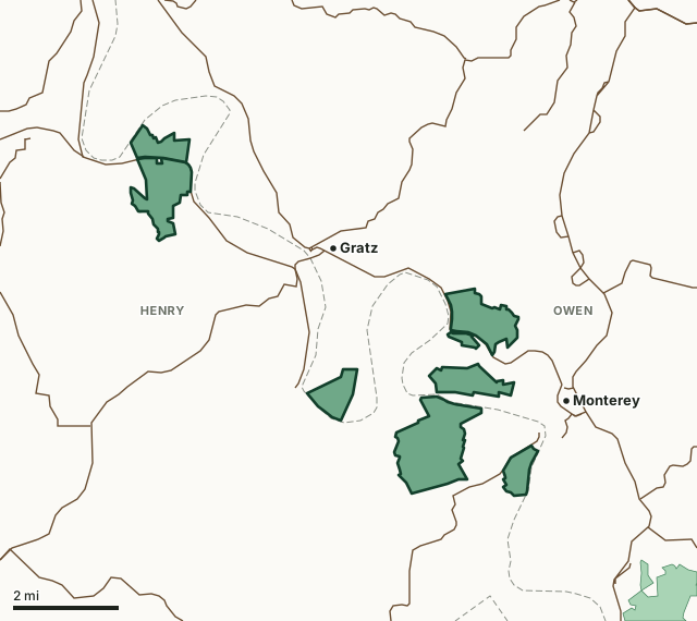
Kentucky River WMAOther KDFWR public hunting areasLake or riverHighwayCounty line
| Size | 3,643 acres (KDFWR) |
|---|---|
| County | Henry County, Owen County |
| KDFWR region | Bluegrass region |
| Deer zone of the county | Zone 1 |
| Deer telechecked, 2025-26 | 69 (25 antlered bucks, 37 does) |
| Elevation | Minimum 438 feet, maximum 891 feet |
| Contact | (502) 535-6335 |
| Nearest towns | Monterey (next to it), Gratz (2 mi) and Owenton (6 mi) |
What are the 2026-27 hunting rules on Kentucky River WMA?
KDFWR lists these rules for the area. Where it says the area is open under statewide seasons, the county's zone rules apply.
Fall Hunting Season
- Open under statewide rules and regulations in effect for the county.
Exceptions
- Closed for modern gun deer season.
- Check-ins and check-outs required during the quota hunt at the Kleber WMA office.
ADA Acreage
- 226 Acres.
Source: KDFWR's page for Kentucky River WMA, read October 2026. Statewide seasons: 2026-27 Kentucky Hunting and Trapping Guide, page 10.
How many deer are taken on Kentucky River WMA?
Hunters telechecked 69 deer on Kentucky River WMA in the 2025-26 season: 25 antlered bucks, 7 button bucks and 37 does. Over the 10 seasons KDFWR reports, the area averaged 58 deer a season, from 41 in 2018-19 to 69 in 2025-26.
| Season | Deer telechecked | Antlered bucks | Does | Firearms | Archery | Crossbow | Muzzleloader |
|---|---|---|---|---|---|---|---|
| 2025-26 | 69 | 25 | 37 | 17 | 29 | 8 | 15 |
| 2024-25 | 55 | 20 | 32 | 10 | 26 | 9 | 10 |
| 2023-24 | 63 | 26 | 34 | 23 | 23 | 5 | 12 |
| 2022-23 | 61 | 13 | 44 | 4 | 30 | 9 | 18 |
| 2021-22 | 57 | 16 | 37 | 1 | 37 | 8 | 11 |
| 2020-21 | 69 | 28 | 36 | 16 | 33 | 7 | 13 |
| 2019-20 | 51 | 11 | 35 | 8 | 28 | 9 | 6 |
| 2018-19 | 41 | 15 | 22 | 2 | 28 | 7 | 4 |
| 2017-18 | 56 | 14 | 36 | 2 | 31 | 11 | 12 |
| 2016-17 | 57 | 21 | 33 | 5 | 43 | 9 | 0 |
Source: KDFWR Harvest Data (Telecheck), deer by public land. Antlered bucks are KDFWR's count of males with visible antlers; the rest of the males are button bucks.
Spring turkey telechecked on the area: 18 in 2025, 13 in 2024, 15 in 2023 and 15 in 2022 (KDFWR Harvest Data, spring season).
What kind of ground is Kentucky River WMA?
KDFWR describes the area's habitat as 80.7% forest, 15.78% open land, 2.77% open water and 0.55% wetland. Elevation runs from 438 feet to 891 feet.
Which county is Kentucky River WMA in?
| County | Acres of the area in it | Deer zone | County deer, 2025-26 | Rank of 120 |
|---|---|---|---|---|
| Henry County | 2,317 | 1 | 1,799 | 25th |
| Owen County | 1,326 | 1 | 2,214 | 14th |
Acres measured by FilledTag on KDFWR public hunting area boundaries and the U.S. Census Bureau 2024 county boundaries. County harvest: KDFWR Harvest Data (Telecheck), deer by county. Zones: KDFWR current deer zones.
How do you get to Kentucky River WMA?
Primary access via US-127 near Monterey, KY. One mile west of Gest (near Lock 3) on HWY 561, ½ mile north of Gest; 1 mile south of Gratz on Brown’s Bottom RD; 4 miles south of Gratz on KY 355. River flood plain and associated uplands, old fields and oak-hickory forest. Mobility impaired access to permit holders in designated area: Welch Tract - Hardin Bottoms. Owned by Kentucky Department of Fish and Wildlife Resources, portions purchased with funds from the Heritage Lands Conservation Fund.
From KDFWR's page for the area.
Highways within 5 miles: US 127, KY 355, KY 22 and KY 389. Nearest towns: Monterey (next to it), Gratz (2 miles), Owenton (6 miles) and Worthville (7 miles).
The closest other public hunting areas with a page here: John A. Kleber WMA (2.5 miles), Twin Eagle WMA (4.3 miles), Dr. James R. Rich WMA (5.1 miles) and T. N. Sullivan WMA (9 miles).
Questions hunters ask
When can you hunt Kentucky River WMA in 2026-27?
KDFWR's 2026-27 rules for Kentucky River WMA: Open under statewide rules and regulations in effect for the county.
How many deer were killed on Kentucky River WMA last season?
Hunters telechecked 69 deer on Kentucky River WMA in the 2025-26 season: 25 antlered bucks and 37 does. The most taken with archery (29).
What county is Kentucky River WMA in?
Henry County (2,317 acres) and Owen County (1,326 acres), measured on KDFWR's boundary.
What deer zone is Kentucky River WMA in?
Henry County is in Zone 1 and Owen County is in Zone 1. Unlimited number of antlerless deer using the statewide deer permit plus additional deer permits. Area rules can be stricter than the zone's, as listed above.
Get a Kentucky hunt plan when they open
Hunt plans for Kentucky are coming. Join the list and you'll hear first. The first 50 hunters in each new state get their plan free.
Until then, the free FilledTag app for iPhone has a map that works in every state, Kentucky included.
Where these numbers come from
- Area rules, size, habitat, contact and directions: KDFWR, Kentucky River WMA.
- Deer, elk and turkey harvest on the area: KDFWR Harvest Data (Telecheck), deer by public land. County harvest: KDFWR Harvest Data (Telecheck), deer by county.
- Boundary: KDFWR public hunting area boundaries. Counties, highways and towns: U.S. Census Bureau 2024 county boundaries; U.S. Census Bureau TIGER/Line 2024 roads; U.S. Census Bureau 2024 Gazetteer. National forest and refuges: U.S. Forest Service national forest ownership; U.S. Fish and Wildlife Service refuge boundaries.
FilledTag is not part of Kentucky Fish and Wildlife. Numbers are copied from KDFWR or measured from public maps; nothing on this page is estimated by FilledTag.
Kentucky hunting All Kentucky WMAs Henry County deer harvest Owen County deer harvest