Stone Mountain WMA and State Natural Area: deer harvest, 2026-27 rules and access
Stone Mountain WMA and State Natural Area is 1,017 acres of public hunting land in Harlan County, in KDFWR's Southeast region. Hunters telechecked 3 deer on the area in the 2025-26 season, 3 antlered bucks among them. KDFWR's 2026-27 rule for the area: Open under statewide rules and regulations in effect for the county.
Data updated October 2026. Rules: KDFWR's page for the area. Harvest: KDFWR Telecheck reports, 2016-17 to 2025-26.
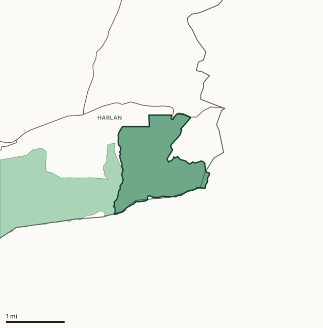
Stone Mountain WMA and State Natural AreaOther KDFWR public hunting areasLake or riverHighwayCounty line
| Size | 1,017 acres (KDFWR) |
|---|---|
| County | Harlan County |
| KDFWR region | Southeast region |
| Deer zone of the county | Zone 4 |
| Deer telechecked, 2025-26 | 3 (3 antlered bucks, 0 does) |
| Elk | In the Elk Management Zone, hunting unit 2 |
| Elevation | Minimum 1683 feet, maximum 2933 feet |
| Contact | (606)-654-2533 |
| Nearest towns | Evarts (8 mi), Harlan (11 mi) and Loyall (12 mi) |
What are the 2026-27 hunting rules on Stone Mountain WMA and State Natural Area?
KDFWR lists these rules for the area. Where it says the area is open under statewide seasons, the county's zone rules apply.
Fall Hunting Season
- Open under statewide rules and regulations in effect for the county.
Source: KDFWR's page for Stone Mountain WMA and State Natural Area, read October 2026. Statewide seasons: 2026-27 Kentucky Hunting and Trapping Guide, page 10.
How many deer are taken on Stone Mountain WMA and State Natural Area?
Hunters telechecked 3 deer on Stone Mountain WMA and State Natural Area in the 2025-26 season: 3 antlered bucks, 0 button bucks and 0 does. Over the 8 seasons KDFWR reports, the area averaged 2 deer a season, from 1 in 2024-25 to 3 in 2025-26.
| Season | Deer telechecked | Antlered bucks | Does | Firearms | Archery | Crossbow | Muzzleloader |
|---|---|---|---|---|---|---|---|
| 2025-26 | 3 | 3 | 0 | 3 | 0 | 0 | 0 |
| 2024-25 | 1 | 1 | 0 | 1 | 0 | 0 | 0 |
| 2023-24 | 1 | 1 | 0 | 1 | 0 | 0 | 0 |
| 2022-23 | 3 | 3 | 0 | 3 | 0 | 0 | 0 |
| 2021-22 | 3 | 3 | 0 | 2 | 1 | 0 | 0 |
| 2020-21 | 0 | 0 | 0 | 0 | 0 | 0 | 0 |
| 2019-20 | 2 | 2 | 0 | 2 | 0 | 0 | 0 |
| 2018-19 | 3 | 3 | 0 | 3 | 0 | 0 | 0 |
| 2017-18 | 0 | 0 | 0 | 0 | 0 | 0 | 0 |
| 2016-17 | 3 | 3 | 0 | 3 | 0 | 0 | 0 |
Source: KDFWR Harvest Data (Telecheck), deer by public land. Antlered bucks are KDFWR's count of males with visible antlers; the rest of the males are button bucks.
Spring turkey telechecked on the area: 2 in 2022 (KDFWR Harvest Data, spring season).
What kind of ground is Stone Mountain WMA and State Natural Area?
KDFWR describes the area's habitat as 99.51% forest and 0.2% open land. Elevation runs from 1683 feet to 2933 feet.
Which county is Stone Mountain WMA and State Natural Area in?
| County | Acres of the area in it | Deer zone | County deer, 2025-26 | Rank of 120 |
|---|---|---|---|---|
| Harlan County | 993 | 4 | 509 | 104th |
Acres measured by FilledTag on KDFWR public hunting area boundaries and the U.S. Census Bureau 2024 county boundaries. County harvest: KDFWR Harvest Data (Telecheck), deer by county. Zones: KDFWR current deer zones.
How do you get to Stone Mountain WMA and State Natural Area?
From Harlan travel approximately 13 miles southeast on HWY 421 to the property on the right. Access is directly off HWY 421, approximately halfway up the mountain there is a sharp curve, just past this curve is a parking area on the right. Access to the parking area should be made when coming down the hill or exiting the parking area should only be made up the hill due to a blind spot on HWY 421 and the angle of the drive. Steep, mountainous terrain, is entirely forested with the exception of a dry man-made lakebed. Good to moderate populations of squirrel, rabbits, deer, turkey and songbirds exist on the area. The area is open under statewide regulations for small game, turkey, and deer seasons. Purchased with Kentucky Heritage Land Conservation funds and is jointly owned and managed by the Kentucky Department of Fish and Wildlife Resources and the Kentucky State Nature Preserves Commission
From KDFWR's page for the area.
Highways within 5 miles: US 421, KY 987, KY 568 and KY 1137. Nearest towns: Evarts (8 miles), Harlan (11 miles), Loyall (12 miles) and Benham (17 miles).
The closest other public hunting areas with a page here: Cranks Creek WMA (next to it), Martins Fork Lake WMA (4.6 miles), Asher Hunting Access Area (6.7 miles) and Kentenia State Forest (11 miles).
Questions hunters ask
When can you hunt Stone Mountain WMA and State Natural Area in 2026-27?
KDFWR's 2026-27 rules for Stone Mountain WMA and State Natural Area: Open under statewide rules and regulations in effect for the county.
How many deer were killed on Stone Mountain WMA and State Natural Area last season?
Hunters telechecked 3 deer on Stone Mountain WMA and State Natural Area in the 2025-26 season: 3 antlered bucks and 0 does. The most taken with firearms (3).
What county is Stone Mountain WMA and State Natural Area in?
All of it is in Harlan County, by KDFWR's boundary.
What deer zone is Stone Mountain WMA and State Natural Area in?
Harlan County is in Zone 4. Up to two deer, only one of which can be antlerless. Antlerless deer cannot be taken during the modern gun season, the early muzzleloader season or the first six days of the late muzzleloader season. Area rules can be stricter than the zone's, as listed above.
Get a Kentucky hunt plan when they open
Hunt plans for Kentucky are coming. Join the list and you'll hear first. The first 50 hunters in each new state get their plan free.
Until then, the free FilledTag app for iPhone has a map that works in every state, Kentucky included.
Where these numbers come from
- Area rules, size, habitat, contact and directions: KDFWR, Stone Mountain WMA and State Natural Area.
- Deer, elk and turkey harvest on the area: KDFWR Harvest Data (Telecheck), deer by public land. County harvest: KDFWR Harvest Data (Telecheck), deer by county.
- Boundary: KDFWR public hunting area boundaries. Counties, highways and towns: U.S. Census Bureau 2024 county boundaries; U.S. Census Bureau TIGER/Line 2024 roads; U.S. Census Bureau 2024 Gazetteer. National forest and refuges: U.S. Forest Service national forest ownership; U.S. Fish and Wildlife Service refuge boundaries.
FilledTag is not part of Kentucky Fish and Wildlife. Numbers are copied from KDFWR or measured from public maps; nothing on this page is estimated by FilledTag.
Kentucky hunting All Kentucky WMAs Harlan County deer harvest