Amarugia Highlands Conservation Area: hunting and access
Amarugia Highlands Conservation Area is 1,082 acres of MDC land in Cass County, 5 miles from Archie. MDC lists deer hunting here (archery and firearms, antlerless permits not allowed). Hunters checked 2,731 deer in Cass County in 2025.
Data updated October 2026. Area facts: MDC's conservation area data, read 2026-10. Harvest: MDC deer harvest summaries, 2021 to 2025.
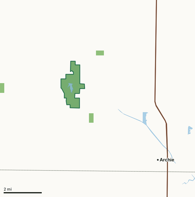
MDC conservation areasAmarugia Highlands Conservation AreaCounty lineLakeHighway
| Size | 1,082 acres |
|---|---|
| County | Cass County |
| Deer harvest unit | Cass County |
| MDC lists for hunting | Deer, Bear, Turkey, Rabbit, Squirrel, Dove and Quail |
| MDC area number | 8310 |
| MDC region | Kansas City |
| Nearest towns | Archie (5 mi), Freeman (6 mi) and Lake Annette (8 mi) |
What is Amarugia Highlands Conservation Area like?
Amarugia Highlands Conservation Area is located in a region once known as "The Kingdom of Amarugia," where a group of people formed their own society and government. A series of prominent hills in this region is still known as the Amarugia Highlands, and the southern portion of the conservation area stretch into part of these highlands. The 1,081-acre area was purchased by the Missouri Department of Conservation in 1983. One of its main attractions is the man-made 45-acre impoundment, Amarugia Lake, which was completed in 1987. The lake was renovated in 2014 and stocked with largemouth bass, channel catfish, bluegill, and redear sunfish. A boat ramp is located on the lake, along with a privy, and several fishing jetties (one is disabled-accessible). The area also has numerous small ponds and access to a short stretch of the South Grand River is available. Terrain varies from bottomland open fields to rolling upland grasslands and woodlands. Open lands are managed for a variety of game and non-game wildlife species. Haying, cropping, and controlled burning are used to maintain plant diversity in open areas. Habitat plantings include trees, shrubs, native grasses, and forbs.
In MDC's words, from the Amarugia Highlands Conservation Area page.
What can you hunt on Amarugia Highlands Conservation Area?
MDC's page for Amarugia Highlands Conservation Area lists: Deer: archery and firearms, antlerless permits not allowed; Bear: archery and firearms; Turkey: archery and firearms; Rabbit; Squirrel; Dove; Quail.
What are the rules on Amarugia Highlands Conservation Area?
Field Trials: Field trials are allowed on this department area only by special use permit. To obtain a special use permit, contact the area manager at the phone number listed for this area in the area details section.
Waterfowl Hunting: Waterfowl hunting is prohibited after 1:00 p.m. on designated portions of this area (one of several MDC lists for this rule).
Every conservation area also follows MDC's standard rules in Chapter 11 of the Wildlife Code; the area's full rules are on MDC's site.
How many deer are taken around Amarugia Highlands Conservation Area?
Amarugia Highlands Conservation Area lies in Cass County. Hunters checked 2,731 deer in Cass County in 2025, against 2,496 in 2024.
| County | Amarugia Highlands Conservation Area acres in it | Deer, 2025 | Deer, 2024 | Deer, 2023 |
|---|---|---|---|---|
| Cass County | 1,082 | 2,731 | 2,496 | 2,662 |
Harvest for the whole county, not the conservation area alone: MDC deer harvest summaries (2021 to 2025 seasons).
How do you get to Amarugia Highlands Conservation Area?
MDC's directions: From I-49/Highway 71 at Archie, take Route A west 5 miles, then Route W north 4.50 miles to the area.
Nearest towns: Archie (5 miles), Freeman (6 miles), Lake Annette (8 miles) and Harrisonville (8 miles). Highways within 5 miles: US 71, I-49 and MO 2.
What other public land is near Amarugia Highlands Conservation Area?
MDC lands within 10 miles:
- Dorsett Hill Prairie Conservation Area: 76 acres, 0.6 miles away
- Bittern Bottoms Conservation Area: 67 acres, 1 mile away
- Dr. Harry and Lina Berrier Memorial Conservation Area: 105 acres, 3 miles away
- James R. Harter Conservation Area: 463 acres, 8.3 miles away
- Harrisonville (Upper Lake): 24 acres, 8.9 miles away
Public land within 3 miles of Amarugia Highlands Conservation Area
Counting Amarugia Highlands Conservation Area itself, 1,232 of the 31,168 acres within 3 miles of its boundary are public land open to the public (4%), by USGS PAD-US 4.1 and MDC conservation area boundaries.
| Manager | Acres within 3 miles |
|---|---|
| MDC conservation areas | 1,232 |
Questions hunters ask
Where is Amarugia Highlands Conservation Area?
In Cass County, 5 miles from Archie.
Can you deer hunt on Amarugia Highlands Conservation Area?
Yes, by MDC's page: archery and firearms, antlerless permits not allowed.
How much public land is around Amarugia Highlands Conservation Area?
1,232 acres within 3 miles of its boundary, Amarugia Highlands Conservation Area included, by USGS PAD-US 4.1 and MDC conservation area boundaries. The closest other MDC area is Dorsett Hill Prairie Conservation Area (0.6 miles).
Get a Missouri hunt plan when they open
Hunt plans for Missouri are coming. Join the list and you'll hear first. The first 50 hunters in each new state get their plan free.
Until then, the free FilledTag app for iPhone has a map that works in every state, Missouri included.
Where these facts come from
- Area description, species, rules and directions: MDC, Amarugia Highlands Conservation Area; MDC conservation area boundaries.
- Boundary and acres: MDC's map layer above. Surrounding public land: USGS PAD-US 4.1 (fee land open to the public) and MDC conservation area boundaries.
- Deer harvest: MDC deer harvest summaries (2021 to 2025 seasons).
FilledTag is not part of the Missouri Department of Conservation. Check MDC's rules and posted signs before you go.