James R. Harter Conservation Area: hunting and access
James R. Harter Conservation Area is 463 acres of MDC land in Cass County, 4 miles from Garden City. MDC lists deer hunting here (archery only, antlerless permits not allowed). Hunters checked 2,731 deer in Cass County in 2025.
Data updated October 2026. Area facts: MDC's conservation area data, read 2026-10. Harvest: MDC deer harvest summaries, 2021 to 2025.
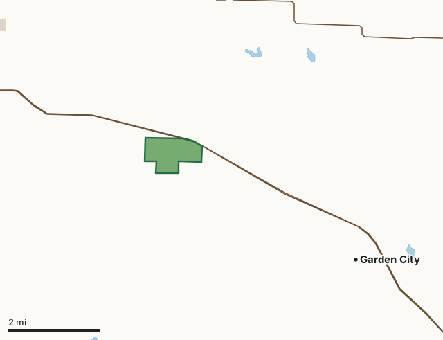
MDC conservation areasCounty, city and regional landJames R. Harter Conservation AreaCounty lineLakeHighway
| Size | 463 acres |
|---|---|
| County | Cass County |
| Deer harvest unit | Cass County |
| MDC lists for hunting | Deer |
| MDC area number | 9401 |
| MDC region | Kansas City |
| Nearest towns | Garden City (4 mi), East Lynne (5 mi) and Harrisonville (5 mi) |
What is James R. Harter Conservation Area like?
James R. Harter Conservation Area is in Cass County and 3.50 miles west of Garden City on the south side of Highway 7.
This 456-acre area contains a mixture of crop fields, grassland, old fields, timber, and Osage orange hedgerows. Eight Mile Creek runs for three-fourths mile through the northwest corner of the area. These diverse habitats support a wide variety of wildlife, including many types of songbirds, quail, deer, and waterfowl. The Harter area is named after James R. Harter, who donated the land to the Conservation Department in 1993. A farmer, Mr. Harter, loved this land and wanted to prevent it from being converted to housing developments or from losing its character under modern farming techniques. To preserve his farm as a home for wildlife, Mr. Harter willed that the land be developed as a Conservation Area as a gift to the people of Missouri, asking only that it bear his name and that the only hunting allowed would be Archery Deer hunting.
In MDC's words, from the James R. Harter Conservation Area page.
What can you hunt on James R. Harter Conservation Area?
MDC's page for James R. Harter Conservation Area lists: Deer: archery only, antlerless permits not allowed.
What are the rules on James R. Harter Conservation Area?
MDC's standard conservation area rules (Chapter 11 of the Wildlife Code) apply; the area's rules on MDC's site list any it adds.
How many deer are taken around James R. Harter Conservation Area?
James R. Harter Conservation Area lies in Cass County. Hunters checked 2,731 deer in Cass County in 2025, against 2,496 in 2024.
| County | James R. Harter Conservation Area acres in it | Deer, 2025 | Deer, 2024 | Deer, 2023 |
|---|---|---|---|---|
| Cass County | 463 | 2,731 | 2,496 | 2,662 |
Harvest for the whole county, not the conservation area alone: MDC deer harvest summaries (2021 to 2025 seasons).
How do you get to James R. Harter Conservation Area?
MDC's directions: From Garden City, take Highway 7 west 4 miles to the junction with Kircher Road, take Kircher Road south.
Nearest towns: Garden City (4 miles), East Lynne (5 miles), Harrisonville (5 miles) and Gunn City (7 miles). Highways within 5 miles: MO 7, US 71, I-49 and MO 2.
What other public land is near James R. Harter Conservation Area?
MDC lands within 10 miles:
- Harrisonville (Upper Lake): 24 acres, 5.2 miles away
- Bittern Bottoms Conservation Area: 67 acres, 6.8 miles away
- Amarugia Highlands Conservation Area: 1,082 acres, 8.3 miles away
- Dorsett Hill Prairie Conservation Area: 76 acres, 8.9 miles away
- Settle's Ford Conservation Area: 7,325 acres, 9.2 miles away
Public land within 3 miles of James R. Harter Conservation Area
Counting James R. Harter Conservation Area itself, 467 of the 25,372 acres within 3 miles of its boundary are public land open to the public (1.8%), by USGS PAD-US 4.1 and MDC conservation area boundaries.
| Manager | Acres within 3 miles |
|---|---|
| MDC conservation areas | 467 |
Questions hunters ask
Where is James R. Harter Conservation Area?
In Cass County, 4 miles from Garden City.
Can you deer hunt on James R. Harter Conservation Area?
Yes, by MDC's page: archery only, antlerless permits not allowed.
How much public land is around James R. Harter Conservation Area?
467 acres within 3 miles of its boundary, James R. Harter Conservation Area included, by USGS PAD-US 4.1 and MDC conservation area boundaries. The closest other MDC area is Harrisonville (Upper Lake) (5.2 miles).
Get a Missouri hunt plan when they open
Hunt plans for Missouri are coming. Join the list and you'll hear first. The first 50 hunters in each new state get their plan free.
Until then, the free FilledTag app for iPhone has a map that works in every state, Missouri included.
Where these facts come from
- Area description, species, rules and directions: MDC, James R. Harter Conservation Area; MDC conservation area boundaries.
- Boundary and acres: MDC's map layer above. Surrounding public land: USGS PAD-US 4.1 (fee land open to the public) and MDC conservation area boundaries.
- Deer harvest: MDC deer harvest summaries (2021 to 2025 seasons).
FilledTag is not part of the Missouri Department of Conservation. Check MDC's rules and posted signs before you go.