Burr Oak Woods Conservation Area: hunting and access
Burr Oak Woods Conservation Area is 1,071 acres of MDC land in Jackson County, next to Lake Tapawingo. MDC lists deer hunting here only on managed hunts. Hunters checked 2,415 deer in Jackson County in 2025.
Data updated October 2026. Area facts: MDC's conservation area data, read 2026-10. Harvest: MDC deer harvest summaries, 2021 to 2025.
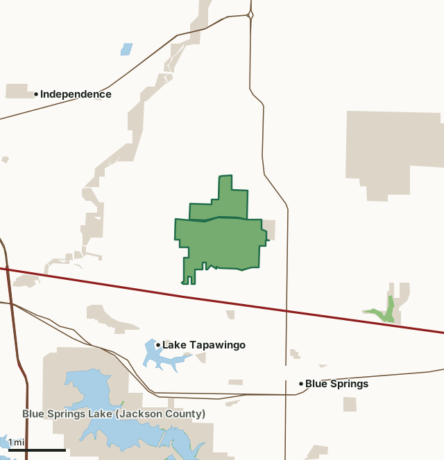
MDC conservation areasCounty, city and regional landBurr Oak Woods Conservation AreaCounty lineLakeHighway
| Size | 1,071 acres in 2 pieces |
|---|---|
| County | Jackson County |
| Deer harvest unit | Jackson County |
| MDC area number | 7812 |
| MDC region | Kansas City |
| MDC managed hunts | deer |
| Nearest towns | Lake Tapawingo (next to it), Blue Springs (2 mi) and Independence (3 mi) |
What is Burr Oak Woods Conservation Area like?
Burr Oak Woods Conservation Area is 1,071-acre property located in Blue Springs just north of I-70.The area was purchased in 1977 and the Nature Center was built in 1982, the first MDC nature center in the State of Missouri. Burr Oak Woods is managed to provide the public with unique wildlife viewing and learning experiences.
Natural features on the area include steep forested hillsides along Burr Oak Creek (the namesake of the property), large limestone boulders and outcrops, restored prairies and woodlands, and a trail complex that will guide visitors through many of these unique features. The trails at Burr Oak Woods provide an escape from its nearby urban/suburban surroundings. Note: Area hours are subject to change during managed hunts.
In MDC's words, from the Burr Oak Woods Conservation Area page.
What are the rules on Burr Oak Woods Conservation Area?
Closings: Special hours apply on this department area. This area is open to public use only as authorized by posting.
Pets and Hunting Dogs: Pets and hunting dogs are prohibited.
Every conservation area also follows MDC's standard rules in Chapter 11 of the Wildlife Code; the area's full rules are on MDC's site.
How many deer are taken around Burr Oak Woods Conservation Area?
Burr Oak Woods Conservation Area lies in Jackson County. Hunters checked 2,415 deer in Jackson County in 2025, against 2,237 in 2024.
| County | Burr Oak Woods Conservation Area acres in it | Deer, 2025 | Deer, 2024 | Deer, 2023 |
|---|---|---|---|---|
| Jackson County | 1,071 | 2,415 | 2,237 | 2,374 |
Harvest for the whole county, not the conservation area alone: MDC deer harvest summaries (2021 to 2025 seasons).
How do you get to Burr Oak Woods Conservation Area?
MDC's directions: In Blue Springs, take Highway 7 north of I-70 for 1.10 miles, then west 1 mile on Park Road to the area.
Nearest towns: Lake Tapawingo (next to it), Blue Springs (2 miles), Independence (3 miles) and Grain Valley (4 miles). Highways within 5 miles: I-70, US 40, MO 291, MO 7 and I-470.
What other public land is near Burr Oak Woods Conservation Area?
MDC lands within 10 miles:
- Lake Remembrance (Blue Springs): 51 acres, 1.9 miles away
- Blue Springs Lake (Jackson County): 692 acres, 2 miles away
- Lake Jacomo (Jackson County): 1,003 acres, 3 miles away
- Jim Bridger Urban Conservation Area: 320 acres, 4.5 miles away
- Lipton Conservation Area: 33 acres, 5.9 miles away
- Prairie Lee Lake (Jackson County): 142 acres, 6.6 miles away
Public land within 3 miles of Burr Oak Woods Conservation Area
Counting Burr Oak Woods Conservation Area itself, 5,208 of the 30,209 acres within 3 miles of its boundary are public land open to the public (17.2%), by USGS PAD-US 4.1 and MDC conservation area boundaries.
| Manager | Acres within 3 miles |
|---|---|
| County, city and regional land | 3,410 |
| MDC conservation areas | 1,798 |
Questions hunters ask
Where is Burr Oak Woods Conservation Area?
In Jackson County, next to Lake Tapawingo.
Can you deer hunt on Burr Oak Woods Conservation Area?
Only on MDC managed hunts, by MDC's page. Managed hunts are applied for through MDC.
How much public land is around Burr Oak Woods Conservation Area?
5,208 acres within 3 miles of its boundary, Burr Oak Woods Conservation Area included, by USGS PAD-US 4.1 and MDC conservation area boundaries. The closest other MDC area is Lake Remembrance (Blue Springs) (1.9 miles).
Get a Missouri hunt plan when they open
Hunt plans for Missouri are coming. Join the list and you'll hear first. The first 50 hunters in each new state get their plan free.
Until then, the free FilledTag app for iPhone has a map that works in every state, Missouri included.
Where these facts come from
- Area description, species, rules and directions: MDC, Burr Oak Woods Conservation Area; MDC conservation area boundaries.
- Boundary and acres: MDC's map layer above. Surrounding public land: USGS PAD-US 4.1 (fee land open to the public) and MDC conservation area boundaries.
- Deer harvest: MDC deer harvest summaries (2021 to 2025 seasons).
FilledTag is not part of the Missouri Department of Conservation. Check MDC's rules and posted signs before you go.