Jim Bridger Urban Conservation Area: hunting and access
Jim Bridger Urban Conservation Area is 320 acres of MDC land in Jackson County, 3 miles from Blue Springs. MDC lists deer hunting here (archery only, antlerless permits allowed). Hunters checked 2,415 deer in Jackson County in 2025.
Data updated October 2026. Area facts: MDC's conservation area data, read 2026-10. Harvest: MDC deer harvest summaries, 2021 to 2025.
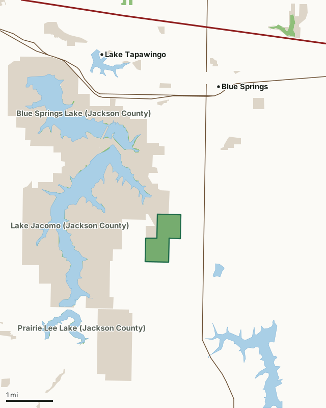
MDC conservation areasCounty, city and regional landJim Bridger Urban Conservation AreaCounty lineLakeHighway
| Size | 320 acres |
|---|---|
| County | Jackson County |
| Deer harvest unit | Jackson County |
| MDC lists for hunting | Deer, Bear and Turkey |
| MDC area number | 8134 |
| MDC region | Kansas City |
| Nearest towns | Blue Springs (3 mi), Lake Tapawingo (4 mi) and Lake Lotawana (4 mi) |
What is Jim Bridger Urban Conservation Area like?
The area consists of 320 acres of diverse habitat including old fields, prairie plantings, crop fields, woodlands, glades, and streams.
In MDC's words, from the Jim Bridger Urban Conservation Area page.
What can you hunt on Jim Bridger Urban Conservation Area?
MDC's page for Jim Bridger Urban Conservation Area lists: Deer: archery only, antlerless permits allowed; Bear: archery only; Turkey: archery only.
What are the rules on Jim Bridger Urban Conservation Area?
MDC's standard conservation area rules (Chapter 11 of the Wildlife Code) apply; the area's rules on MDC's site list any it adds.
How many deer are taken around Jim Bridger Urban Conservation Area?
Jim Bridger Urban Conservation Area lies in Jackson County. Hunters checked 2,415 deer in Jackson County in 2025, against 2,237 in 2024.
| County | Jim Bridger Urban Conservation Area acres in it | Deer, 2025 | Deer, 2024 | Deer, 2023 |
|---|---|---|---|---|
| Jackson County | 320 | 2,415 | 2,237 | 2,374 |
Harvest for the whole county, not the conservation area alone: MDC deer harvest summaries (2021 to 2025 seasons).
How do you get to Jim Bridger Urban Conservation Area?
MDC's directions: From Blue Springs at the Highways 40/7 junction, take Highway 7 south 3.50 miles, then Cowherd Road west 1.20 miles, and Jasper Bell Road north 0.50 mile.
Nearest towns: Blue Springs (3 miles), Lake Tapawingo (4 miles), Lake Lotawana (4 miles) and Tarsney Lakes (4 miles). Highways within 5 miles: MO 291, I-470, US 40, I-70 and US 50.
What other public land is near Jim Bridger Urban Conservation Area?
MDC lands within 10 miles:
- Lake Jacomo (Jackson County): 1,003 acres, next to it
- Blue Springs Lake (Jackson County): 692 acres, 1.4 miles away
- Prairie Lee Lake (Jackson County): 142 acres, 1.8 miles away
- Lake Remembrance (Blue Springs): 51 acres, 4.4 miles away
- James A. Reed Memorial Wildlife Area: 3,087 acres, 4.5 miles away
- Burr Oak Woods Conservation Area: 1,071 acres, 4.5 miles away
Public land within 3 miles of Jim Bridger Urban Conservation Area
Counting Jim Bridger Urban Conservation Area itself, 7,004 of the 24,446 acres within 3 miles of its boundary are public land open to the public (28.7%), by USGS PAD-US 4.1 and MDC conservation area boundaries.
| Manager | Acres within 3 miles |
|---|---|
| County, city and regional land | 5,137 |
| MDC conservation areas | 1,867 |
Questions hunters ask
Where is Jim Bridger Urban Conservation Area?
In Jackson County, 3 miles from Blue Springs.
Can you deer hunt on Jim Bridger Urban Conservation Area?
Yes, by MDC's page: archery only, antlerless permits allowed.
How much public land is around Jim Bridger Urban Conservation Area?
7,004 acres within 3 miles of its boundary, Jim Bridger Urban Conservation Area included, by USGS PAD-US 4.1 and MDC conservation area boundaries. The closest other MDC area is Lake Jacomo (Jackson County) (next to it).
Get a Missouri hunt plan when they open
Hunt plans for Missouri are coming. Join the list and you'll hear first. The first 50 hunters in each new state get their plan free.
Until then, the free FilledTag app for iPhone has a map that works in every state, Missouri included.
Where these facts come from
- Area description, species, rules and directions: MDC, Jim Bridger Urban Conservation Area; MDC conservation area boundaries.
- Boundary and acres: MDC's map layer above. Surrounding public land: USGS PAD-US 4.1 (fee land open to the public) and MDC conservation area boundaries.
- Deer harvest: MDC deer harvest summaries (2021 to 2025 seasons).
FilledTag is not part of the Missouri Department of Conservation. Check MDC's rules and posted signs before you go.