James A. Reed Memorial Wildlife Area: hunting and access
James A. Reed Memorial Wildlife Area is 3,087 acres of MDC land in Jackson County, next to Greenwood. MDC lists deer hunting here only on managed hunts. Hunters checked 2,415 deer in Jackson County in 2025.
Data updated October 2026. Area facts: MDC's conservation area data, read 2026-10. Harvest: MDC deer harvest summaries, 2021 to 2025.
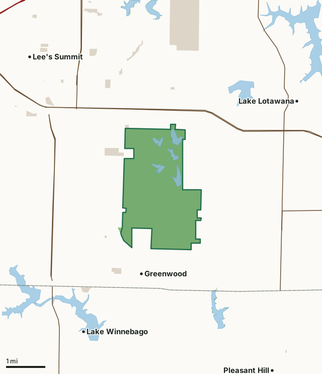
MDC conservation areasCounty, city and regional landJames A. Reed Memorial Wildlife AreaCounty lineLakeHighway
| Size | 3,087 acres |
|---|---|
| County | Jackson County |
| Deer harvest unit | Jackson County |
| MDC lists for hunting | Rabbit, Squirrel and Dove |
| MDC area number | 5501 |
| MDC region | Kansas City |
| MDC managed hunts | deer |
| Camping (MDC) | designated camping sites and special use permit required |
| Shooting range (MDC) | archery |
| Nearest towns | Greenwood (next to it), Lake Winnebago (2 mi) and Lake Lotawana (3 mi) |
What is James A. Reed Memorial Wildlife Area like?
The James A. Reed Memorial Wildlife Area is located in Jackson County, south of Highway 50 near Lee's Summit. This wildlife area was established in 1952 after Mrs. Nell Reed donated 731 acres of land to the Missouri Department of Conservation in memory of her husband, Senator James A. Reed. Additional tracts were purchased using federal monies and department funds to bring the area to its present 3,084 acres. Development of the area and construction of lakes began in 1957. Since then, over 252 acres of water have been impounded to form 12 lakes, ranging in size from one to 42 acres. Most lakes contain largemouth bass, channel catfish, crappie, bluegill, and redear sunfish. In addition, hybrid striped bass have been stocked in most of the lakes, and rainbow trout are stocked for the winter fishing season (Nov-Mar) in Coot and Plover lakes and in Honker Pond (kids only). The area also has numerous small ponds. Woodlands, native grass plantings, shrub plantings, and crop fields are managed to provide year-round food for wildlife. Giant Canada geese nest and winter at the Reed Area. The area also supports good numbers of white-tailed deer. This wildlife area was acquired, developed, and is managed in part through the Dingell-Johnson Sport Fish Restoration Act and the Pittman-Robertson Wildlife Restoration Act administered by the U.S. Fish and Wildlife Service.
In MDC's words, from the James A. Reed Memorial Wildlife Area page.
What can you hunt on James A. Reed Memorial Wildlife Area?
MDC's page for James A. Reed Memorial Wildlife Area lists: Rabbit; Squirrel; Dove. It also lists managed hunts for deer; MDC's managed deer hunt list has the dates and how to apply.
What are the rules on James A. Reed Memorial Wildlife Area?
Closings: Special hours apply on this department area. This area is open to public use only as authorized by posting.
Camping: Youth group camping permitted by Special Use Permit. No other overnight camping allowed.
Target Shooting and Shooting Ranges: An unstaffed range is located on this department area. Target shooting is not allowed anywhere on this area except for designated shooting range(s). Shooting hours are one-half hour before sunrise to one-half hour after sunset. Ranges may be closed to public use at any time for maintenance or department sponsored events or programs. Possession of alcoholic beverages is prohibited on all ranges and associated parking lots. Groups of more than 10 people must obtain a special use permit prior to using the range. To obtain a special use permit, contact the area manager at the phone number listed...
Field Trials: Field trials are allowed on this department area only by special use permit. To obtain a special use permit, contact the area manager at the phone number listed for this area in the area details section.
Dove Hunting: Use or possession of lead shot is prohibited for hunting doves on this area.
Waterfowl Hunting: Waterfowl hunting is prohibited after 1:00 p.m. on designated portions of this area (one of several MDC lists for this rule).
Every conservation area also follows MDC's standard rules in Chapter 11 of the Wildlife Code; the area's full rules are on MDC's site.
How many deer are taken around James A. Reed Memorial Wildlife Area?
James A. Reed Memorial Wildlife Area lies in Jackson County. Hunters checked 2,415 deer in Jackson County in 2025, against 2,237 in 2024.
| County | James A. Reed Memorial Wildlife Area acres in it | Deer, 2025 | Deer, 2024 | Deer, 2023 |
|---|---|---|---|---|
| Jackson County | 3,087 | 2,415 | 2,237 | 2,374 |
Harvest for the whole county, not the conservation area alone: MDC deer harvest summaries (2021 to 2025 seasons).
How do you get to James A. Reed Memorial Wildlife Area?
MDC's directions: From Lee's Summit, take Highway 50 east 1 mile, then SE Ranson Road (Route RA) south 0.75 mile to the area entrance.
Nearest towns: Greenwood (next to it), Lake Winnebago (2 miles), Lake Lotawana (3 miles) and Lee's Summit (3 miles). Highways within 5 miles: US 50, MO 291, MO 7, I-470 and MO 58.
What other public land is near James A. Reed Memorial Wildlife Area?
MDC lands within 10 miles:
- Pleasant Hill City Lake: 90 acres, 1.1 miles away
- Prairie Lee Lake (Jackson County): 142 acres, 2.6 miles away
- Lake Jacomo (Jackson County): 1,003 acres, 3.5 miles away
- Jim Bridger Urban Conservation Area: 320 acres, 4.5 miles away
- Lone Jack Lake Conservation Area: 292 acres, 5.5 miles away
- Jackson County (Longview Lake): 937 acres, 6 miles away
Public land within 3 miles of James A. Reed Memorial Wildlife Area
Counting James A. Reed Memorial Wildlife Area itself, 3,952 of the 39,757 acres within 3 miles of its boundary are public land open to the public (9.9%), by USGS PAD-US 4.1 and MDC conservation area boundaries.
| Manager | Acres within 3 miles |
|---|---|
| MDC conservation areas | 3,220 |
| County, city and regional land | 732 |
Questions hunters ask
Where is James A. Reed Memorial Wildlife Area?
In Jackson County, next to Greenwood.
Can you deer hunt on James A. Reed Memorial Wildlife Area?
Only on MDC managed hunts, by MDC's page. Managed hunts are applied for through MDC.
How much public land is around James A. Reed Memorial Wildlife Area?
3,952 acres within 3 miles of its boundary, James A. Reed Memorial Wildlife Area included, by USGS PAD-US 4.1 and MDC conservation area boundaries. The closest other MDC area is Pleasant Hill City Lake (1.1 miles).
Get a Missouri hunt plan when they open
Hunt plans for Missouri are coming. Join the list and you'll hear first. The first 50 hunters in each new state get their plan free.
Until then, the free FilledTag app for iPhone has a map that works in every state, Missouri included.
Where these facts come from
- Area description, species, rules and directions: MDC, James A. Reed Memorial Wildlife Area; MDC conservation area boundaries.
- Boundary and acres: MDC's map layer above. Surrounding public land: USGS PAD-US 4.1 (fee land open to the public) and MDC conservation area boundaries.
- Deer harvest: MDC deer harvest summaries (2021 to 2025 seasons).
FilledTag is not part of the Missouri Department of Conservation. Check MDC's rules and posted signs before you go.