Cedar Grove Conservation Area: hunting and access
Cedar Grove Conservation Area is 880 acres of MDC land in Dent County, 14 miles from Salem. MDC lists deer hunting here (archery and firearms, antlerless permits allowed). Hunters checked 2,659 deer in Dent County in 2025.
Data updated October 2026. Area facts: MDC's conservation area data, read 2026-10. Harvest: MDC deer harvest summaries, 2021 to 2025.
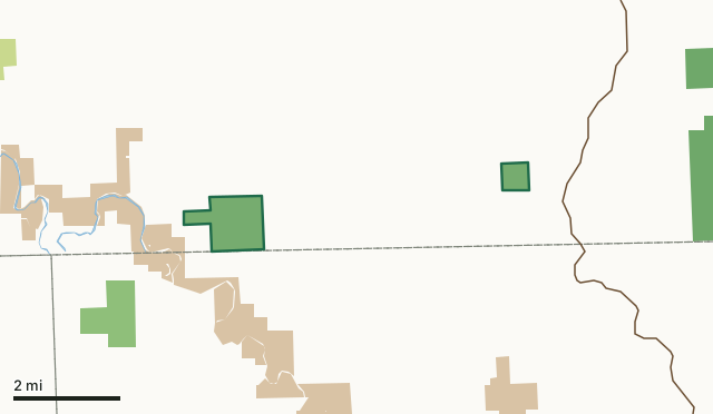
MDC conservation areasNational forestNational park land (Ozark National Scenic Riverways and others)Other state landCedar Grove Conservation AreaCounty lineLakeHighway
| Size | 880 acres in 2 pieces |
|---|---|
| County | Dent County |
| Deer harvest unit | Dent County |
| MDC lists for hunting | Deer, Bear, Turkey and Squirrel |
| MDC area number | 4645 |
| MDC region | Ozark |
| Camping (MDC) | open camping - walk-in/float-in/backpack |
| Nearest towns | Salem (14 mi), Raymondville (14 mi) and Bunker (15 mi) |
What is Cedar Grove Conservation Area like?
Cedar Grove Conservation Area covers 880 acres on two separate tracts in southwest Dent County, between Salem and Akers Ferry. Access to the east tract is off of Route WW and the west tract is off of Route K.
This area is entirely forested with the exception of two small glades. The forest consists of various oaks, hickories, shortleaf pine and lesser species native to this region. Dogwood (the state tree) is abundant and comes into full bloom in the early spring. The Conservation Commission began acquiring this property back in 1952. All the land was purchased from private landowners. During your visit to Cedar Grove Conservation Area, you may view various forest improvement practices designed to improve wildlife habitat, maintain watershed quality, and enhance tree growth, quality, and species composition. Any disturbance is only temporary and the forest will soon return to normal.
In MDC's words, from the Cedar Grove Conservation Area page.
What can you hunt on Cedar Grove Conservation Area?
MDC's page for Cedar Grove Conservation Area lists: Deer: archery and firearms, antlerless permits allowed; Bear: archery and firearms; Turkey: archery and firearms; Squirrel.
What are the rules on Cedar Grove Conservation Area?
MDC's standard conservation area rules (Chapter 11 of the Wildlife Code) apply; the area's rules on MDC's site list any it adds.
How many deer are taken around Cedar Grove Conservation Area?
Cedar Grove Conservation Area lies in Dent County. Hunters checked 2,659 deer in Dent County in 2025, against 2,584 in 2024.
| County | Cedar Grove Conservation Area acres in it | Deer, 2025 | Deer, 2024 | Deer, 2023 |
|---|---|---|---|---|
| Dent County | 880 | 2,659 | 2,584 | 3,865 |
Harvest for the whole county, not the conservation area alone: MDC deer harvest summaries (2021 to 2025 seasons).
How do you get to Cedar Grove Conservation Area?
MDC's directions: To the larger tract(720 acres) : From Jadwin, take Route K south 3 miles to the area.
Nearest towns: Salem (14 miles), Raymondville (14 miles), Bunker (15 miles) and Licking (15 miles). Highways within 5 miles: MO 19.
What other public land is near Cedar Grove Conservation Area?
MDC lands within 10 miles:
- Sunklands Conservation Area: 40,675 acres, 4 miles away
- Angeline Conservation Area: 40,078 acres, 9.8 miles away
Public land within 3 miles of Cedar Grove Conservation Area
Counting Cedar Grove Conservation Area itself, 4,426 of the 46,401 acres within 3 miles of its boundary are public land open to the public (9.5%), by USGS PAD-US 4.1 and MDC conservation area boundaries.
| Manager | Acres within 3 miles |
|---|---|
| National park land (Ozark National Scenic Riverways and others) | 2,968 |
| MDC conservation areas | 1,457 |
| National forest | 1 |
Questions hunters ask
Where is Cedar Grove Conservation Area?
In Dent County, 14 miles from Salem.
Can you deer hunt on Cedar Grove Conservation Area?
Yes, by MDC's page: archery and firearms, antlerless permits allowed.
How much public land is around Cedar Grove Conservation Area?
4,426 acres within 3 miles of its boundary, Cedar Grove Conservation Area included, by USGS PAD-US 4.1 and MDC conservation area boundaries. The closest other MDC area is Sunklands Conservation Area (4 miles).
Get a Missouri hunt plan when they open
Hunt plans for Missouri are coming. Join the list and you'll hear first. The first 50 hunters in each new state get their plan free.
Until then, the free FilledTag app for iPhone has a map that works in every state, Missouri included.
Where these facts come from
- Area description, species, rules and directions: MDC, Cedar Grove Conservation Area; MDC conservation area boundaries.
- Boundary and acres: MDC's map layer above. Surrounding public land: USGS PAD-US 4.1 (fee land open to the public) and MDC conservation area boundaries.
- Deer harvest: MDC deer harvest summaries (2021 to 2025 seasons).
FilledTag is not part of the Missouri Department of Conservation. Check MDC's rules and posted signs before you go.