Angeline Conservation Area: hunting and access
Angeline Conservation Area is 40,078 acres of MDC land in Shannon County, next to Eminence. MDC lists deer hunting here (archery and firearms, antlerless permits allowed). Hunters checked 3,030 deer in Shannon County in 2025.
Data updated October 2026. Area facts: MDC's conservation area data, read 2026-10. Harvest: MDC deer harvest summaries, 2021 to 2025.
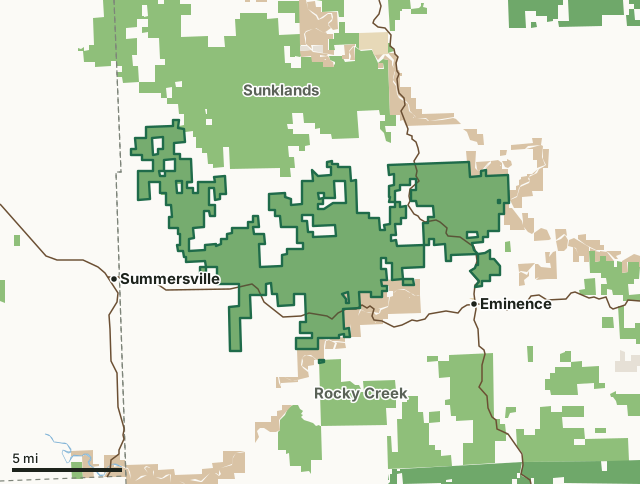
MDC conservation areasNational forestNational park land (Ozark National Scenic Riverways and others)State parks and historic sitesLand trusts and other open landAngeline Conservation AreaCounty lineLakeHighway
| Size | 40,078 acres in 3 pieces |
|---|---|
| County | Shannon County |
| Deer harvest unit | Shannon County |
| MDC lists for hunting | Deer, Bear, Turkey, Rabbit, Squirrel, Dove and Quail |
| MDC area number | 9512 |
| MDC region | Ozark |
| Camping (MDC) | open camping - walk-in/float-in/backpack |
| Shooting range (MDC) | shotgun and rifle or pistol |
| Nearest towns | Eminence (next to it), Summersville (3 mi) and Birch Tree (8 mi) |
What is Angeline Conservation Area like?
The Angeline Conservation Area lies north of the Jacks Fork and west of the Current River. The 39,590-acre area is north of Eminence and extends 15 miles west to near Summersville. Numerous small springs, seeps and sinkholes are found on the area due to the karst topography. Clow, Alley Spring and Flat Rock conservation areas and the Kerr-McGee purchase were combined to create this single conservation area. Points of interest include a scenic overlook on Highway 19, the Eminence Office, Bay Branch Shooting Range, Flat Rock Lookout Tower, Lick Log Hollow Nature Trail a one mile interpretive hike and a day use Equestrian loop trail system that is 9.5 miles long.
The area is managed with a sustainable ecological approach to multiple-use management. The management goal is to improve the overall health and vigor of the forest, woodland, and glade natural communities indigenous to the landtype association. The management will guide these natural communities to more ecological and biological stable conditions that will enhance productivity and value over time. Management techniques include prescribed fire, invasive species control, planting, selective and regeneration harvests. Other areas are set aside for old-growth habitat, and will not be actively managed by the Department. With almost 40,000 acres of public land, the Angeline CA provides for a wide range of outdoor activities. These include nature viewing, bird watching, hiking, dispersed primitive camping, and hunting and fishing opportunities.
In MDC's words, from the Angeline Conservation Area page.
What can you hunt on Angeline Conservation Area?
MDC's page for Angeline Conservation Area lists: Deer: archery and firearms, antlerless permits allowed; Bear: archery and firearms; Turkey: archery and firearms; Rabbit; Squirrel; Dove; Quail.
What are the rules on Angeline Conservation Area?
Target Shooting and Shooting Ranges: An unstaffed range is located on this department area. Target shooting is not allowed anywhere on this area except for designated shooting range(s). Shooting hours are one-half hour before sunrise to one-half hour after sunset. Ranges may be closed to public use at any time for maintenance or department sponsored events or programs. Possession of alcoholic beverages is prohibited on all ranges and associated parking lots. Groups of more than 10 people must obtain a special use permit prior to using the range. To obtain a special use permit, contact the area manager at the phone number listed...
Every conservation area also follows MDC's standard rules in Chapter 11 of the Wildlife Code; the area's full rules are on MDC's site.
How many deer are taken around Angeline Conservation Area?
Angeline Conservation Area lies in Shannon County. Hunters checked 3,030 deer in Shannon County in 2025, against 2,069 in 2024.
| County | Angeline Conservation Area acres in it | Deer, 2025 | Deer, 2024 | Deer, 2023 |
|---|---|---|---|---|
| Shannon County | 40,078 | 3,030 | 2,069 | 4,146 |
Harvest for the whole county, not the conservation area alone: MDC deer harvest summaries (2021 to 2025 seasons).
How do you get to Angeline Conservation Area?
MDC's directions: North of Eminence and extending 15 miles west toward Summersville. Enter from Highways 19 and 106 or Route D.
Nearest towns: Eminence (next to it), Summersville (3 miles), Birch Tree (8 miles) and Montier (10 miles). Highways within 5 miles: MO 106, MO 19 and MO 17.
What other public land is near Angeline Conservation Area?
MDC lands within 10 miles:
- Sunklands Conservation Area: 40,675 acres, next to it
- Rocky Creek Conservation Area: 42,323 acres, next to it
- Midvale Conservation Area: 85 acres, 5.6 miles away
- Gist Ranch Conservation Area: 11,206 acres, 6.5 miles away
- Barn Hollow Natural Area: 251 acres, 8.4 miles away
- Peck Ranch Conservation Area: 29,462 acres, 8.7 miles away
Public land within 3 miles of Angeline Conservation Area
Counting Angeline Conservation Area itself, 71,535 of the 179,327 acres within 3 miles of its boundary are public land open to the public (39.9%), by USGS PAD-US 4.1 and MDC conservation area boundaries.
| Manager | Acres within 3 miles |
|---|---|
| MDC conservation areas | 61,307 |
| National park land (Ozark National Scenic Riverways and others) | 10,217 |
| State parks and historic sites | 11 |
Questions hunters ask
Where is Angeline Conservation Area?
In Shannon County, next to Eminence.
Can you deer hunt on Angeline Conservation Area?
Yes, by MDC's page: archery and firearms, antlerless permits allowed.
How much public land is around Angeline Conservation Area?
71,535 acres within 3 miles of its boundary, Angeline Conservation Area included, by USGS PAD-US 4.1 and MDC conservation area boundaries. The closest other MDC area is Sunklands Conservation Area (next to it).
Get a Missouri hunt plan when they open
Hunt plans for Missouri are coming. Join the list and you'll hear first. The first 50 hunters in each new state get their plan free.
Until then, the free FilledTag app for iPhone has a map that works in every state, Missouri included.
Where these facts come from
- Area description, species, rules and directions: MDC, Angeline Conservation Area; MDC conservation area boundaries.
- Boundary and acres: MDC's map layer above. Surrounding public land: USGS PAD-US 4.1 (fee land open to the public) and MDC conservation area boundaries.
- Deer harvest: MDC deer harvest summaries (2021 to 2025 seasons).
FilledTag is not part of the Missouri Department of Conservation. Check MDC's rules and posted signs before you go.