Rocky Creek Conservation Area: hunting and access
Rocky Creek Conservation Area is 42,323 acres of MDC land in Shannon County, 2 miles from Eminence. MDC lists deer hunting here (archery and firearms, antlerless permits allowed). Hunters checked 3,030 deer in Shannon County in 2025.
Data updated October 2026. Area facts: MDC's conservation area data, read 2026-10. Harvest: MDC deer harvest summaries, 2021 to 2025.
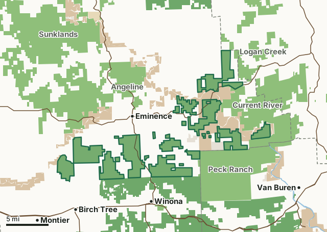
MDC conservation areasNational forestNational park land (Ozark National Scenic Riverways and others)State parks and historic sitesLand trusts and other open landRocky Creek Conservation AreaCounty lineLakeHighway
| Size | 42,323 acres in 26 pieces |
|---|---|
| County | Shannon County |
| Deer harvest unit | Shannon County |
| MDC lists for hunting | Deer, Bear, Turkey, Rabbit, Squirrel, Dove and Quail |
| MDC area number | 4629 |
| MDC region | Ozark |
| Camping (MDC) | open camping - walk-in/float-in/backpack and individual campsites |
| Nearest towns | Eminence (2 mi), Winona (3 mi) and Birch Tree (3 mi) |
What is Rocky Creek Conservation Area like?
Rocky Creek Conservation Area Background: The Rocky Creek Conservation Area (CA) contains over 42,000 acres in the southern and eastern parts of Shannon County. Major tracts can be accessed along Highway 19 south, Highway 106, and from Routes H and E. Additional tracts are located north and south of Highway 106, starting 5 miles east of Eminence and continuing to the Reynolds County line. Tracts vary in size from over 6,000 acres to 80 acres, some of which were originally state forests, including Indian Creek, Bloom Creek, Blairs Creek, Mule Mountain, and the Rocky Creek State Forest. Others were part of the Kerr-McGee land acquisition that happened in 1995-1996.
Rocky Creek CA is in the Ozark Highland Section and the Current River Hills Subsection (Nigh & Schroeder, 2002). The majority of the conservation area is in the Oak-Pine Woodland/Forest Hills Land Type Association. The remaining area is in the Eminence Igneous Glade/Oak Forest Hills land type that includes Coot, Peter Mooney, Mill, Barnett, Vance, and Buttin Rock mountains. Rocky Creek CA is a forested landscape, resulting from The Great Cutover around the turn of the century. Today, woodlands and forests are covered by mostly even-aged black oak, scarlet oak, white oak, post oak, hickory, and some shortleaf pine. Although the conservation area is in the native shortleaf pine range, many pine sites have been invaded by other hardwoods species that are now past or reaching maturity. The area is managed with a sustainable ecological approach to multiple-use management. The goal of the...
In MDC's words, from the Rocky Creek Conservation Area page.
What can you hunt on Rocky Creek Conservation Area?
MDC's page for Rocky Creek Conservation Area lists: Deer: archery and firearms, antlerless permits allowed; Bear: archery and firearms; Turkey: archery and firearms; Rabbit; Squirrel; Dove; Quail.
What are the rules on Rocky Creek Conservation Area?
MDC's standard conservation area rules (Chapter 11 of the Wildlife Code) apply; the area's rules on MDC's site list any it adds.
How many deer are taken around Rocky Creek Conservation Area?
Rocky Creek Conservation Area lies in Shannon County. Hunters checked 3,030 deer in Shannon County in 2025, against 2,069 in 2024.
| County | Rocky Creek Conservation Area acres in it | Deer, 2025 | Deer, 2024 | Deer, 2023 |
|---|---|---|---|---|
| Shannon County | 42,323 | 3,030 | 2,069 | 4,146 |
Harvest for the whole county, not the conservation area alone: MDC deer harvest summaries (2021 to 2025 seasons).
How do you get to Rocky Creek Conservation Area?
MDC's directions: The Rocky Creek Conservation Area contains 39,546 acres in the south and east parts of Shannon County. Major tracts can be accessed from Highway 19, Routes H, and E going south off of Highway 106. Additional tracts are located north and south of Highway 106 starting five miles east of Eminence, continuing to the Reynolds County line. Tracts vary in size from over 6,000 acres to 80 acres. Access to areas varies from paved roads to unimproved woods roads, to areas that are only accessible by foot. Detailed ownership maps are available from the Eminence District Office.
Nearest towns: Eminence (2 miles), Winona (3 miles), Birch Tree (3 miles) and Montier (6 miles). Highways within 5 miles: US 60, MO 106, MO 19 and MO 99.
What other public land is near Rocky Creek Conservation Area?
MDC lands within 10 miles:
- Peck Ranch Conservation Area: 29,462 acres, next to it
- Angeline Conservation Area: 40,078 acres, next to it
- Current River Conservation Area: 29,828 acres, next to it
- Logan Creek Conservation Area: 13,156 acres, next to it
- Twin Pines Conservation Center: 459 acres, 3.3 miles away
- Birch Creek Conservation Area: 5,581 acres, 6 miles away
Public land within 3 miles of Rocky Creek Conservation Area
Counting Rocky Creek Conservation Area itself, 127,905 of the 251,732 acres within 3 miles of its boundary are public land open to the public (50.8%), by USGS PAD-US 4.1 and MDC conservation area boundaries.
| Manager | Acres within 3 miles |
|---|---|
| MDC conservation areas | 90,698 |
| National park land (Ozark National Scenic Riverways and others) | 20,102 |
| National forest | 15,598 |
| Land trusts and other open land | 1,496 |
| State parks and historic sites | 11 |
Questions hunters ask
Where is Rocky Creek Conservation Area?
In Shannon County, 2 miles from Eminence.
Can you deer hunt on Rocky Creek Conservation Area?
Yes, by MDC's page: archery and firearms, antlerless permits allowed.
How much public land is around Rocky Creek Conservation Area?
127,905 acres within 3 miles of its boundary, Rocky Creek Conservation Area included, by USGS PAD-US 4.1 and MDC conservation area boundaries. The closest other MDC area is Peck Ranch Conservation Area (next to it).
Get a Missouri hunt plan when they open
Hunt plans for Missouri are coming. Join the list and you'll hear first. The first 50 hunters in each new state get their plan free.
Until then, the free FilledTag app for iPhone has a map that works in every state, Missouri included.
Where these facts come from
- Area description, species, rules and directions: MDC, Rocky Creek Conservation Area; MDC conservation area boundaries.
- Boundary and acres: MDC's map layer above. Surrounding public land: USGS PAD-US 4.1 (fee land open to the public) and MDC conservation area boundaries.
- Deer harvest: MDC deer harvest summaries (2021 to 2025 seasons).
FilledTag is not part of the Missouri Department of Conservation. Check MDC's rules and posted signs before you go.