Columbia Bottom Conservation Area: hunting and access
Columbia Bottom Conservation Area is 4,386 acres of MDC land in St. Louis County, next to Spanish Lake. MDC lists deer hunting here only on managed hunts. Hunters checked 1,922 deer in St. Louis County in 2025.
Data updated October 2026. Area facts: MDC's conservation area data, read 2026-10. Harvest: MDC deer harvest summaries, 2021 to 2025.
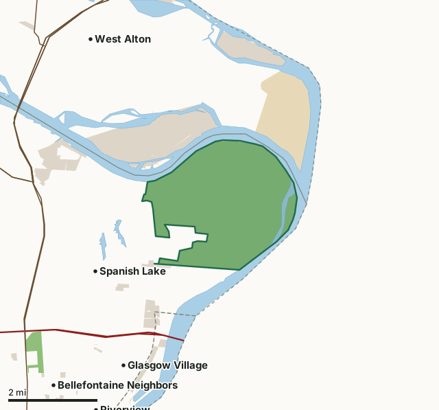
MDC conservation areasState parks and historic sitesCounty, city and regional landLand trusts and other open landColumbia Bottom Conservation AreaCounty lineLakeHighway
| Size | 4,386 acres |
|---|---|
| County | St. Louis County |
| Deer harvest unit | St. Louis County |
| MDC lists for hunting | Squirrel and Dove |
| MDC area number | 9736 |
| MDC region | St. Louis |
| MDC managed hunts | deer |
| Nearest towns | Spanish Lake (next to it), Glasgow Village (2 mi) and West Alton (3 mi) |
What is Columbia Bottom Conservation Area like?
Columbia Bottom is for those who love wide, open spaces. It's located in a floodplain at the Confluence of the Mississippi and Missouri Rivers, the two largest in North America. The area features a paved, level hiking and biking trail that partially traverses the area with an out-and-back path. The trail, and much of the Columbia Bottom Area itself, has been reshaped by the dynamic forces of nature through recurring flooding. A boat ramp enables boaters and anglers to put in to the Missouri River, and a separate access gets paddlers onto the Mississippi.
In MDC's words, from the Columbia Bottom Conservation Area page.
What can you hunt on Columbia Bottom Conservation Area?
MDC's page for Columbia Bottom Conservation Area lists: Squirrel; Dove. It also lists managed hunts for deer; MDC's managed deer hunt list has the dates and how to apply.
What are the rules on Columbia Bottom Conservation Area?
Closings: Special hours apply on this department area. This area is open to public use only as authorized by posting. Portions of this department area are closed to protect waterfowl from October 15 through March 1.
Hunting: Nontoxic shot is required for all hunting with a shotgun on this area. Use or possession of lead shot is prohibited.
Waterfowl Hunting: Waterfowl hunting is prohibited after 1:00 p.m. on designated portions of this area (one of several MDC lists for this rule).
Every conservation area also follows MDC's standard rules in Chapter 11 of the Wildlife Code; the area's full rules are on MDC's site.
How many deer are taken around Columbia Bottom Conservation Area?
Columbia Bottom Conservation Area lies in St. Louis County. Hunters checked 1,922 deer in St. Louis County in 2025, against 1,917 in 2024.
| County | Columbia Bottom Conservation Area acres in it | Deer, 2025 | Deer, 2024 | Deer, 2023 |
|---|---|---|---|---|
| St. Louis County | 4,386 | 1,922 | 1,917 | 2,015 |
Harvest for the whole county, not the conservation area alone: MDC deer harvest summaries (2021 to 2025 seasons).
How do you get to Columbia Bottom Conservation Area?
MDC's directions: In North St. Louis County, take the Riverview Drive exit from I-270, then Riverview north about 2.50 miles to the area.
Nearest towns: Spanish Lake (next to it), Glasgow Village (2 miles), West Alton (3 miles) and Riverview (4 miles). Highways within 5 miles: MO 367, US 67, I-270, MO 140 and MO 94.
What other public land is near Columbia Bottom Conservation Area?
MDC lands within 10 miles:
- Sunfish Lake (St. Louis County): 27 acres, 0.6 miles away
- Spanish Lake (St. Louis County): 31 acres, 1.1 miles away
- Bellefontaine Conservation Area: 142 acres, 2.9 miles away
- Upper Mississippi Conservation Area: 12,715 acres, 4.1 miles away
- Pelican Island Access: 43 acres, 5.3 miles away
Public land within 3 miles of Columbia Bottom Conservation Area
Counting Columbia Bottom Conservation Area itself, 8,066 of the 42,565 acres within 3 miles of its boundary are public land open to the public (18.9%), by USGS PAD-US 4.1 and MDC conservation area boundaries.
| Manager | Acres within 3 miles |
|---|---|
| MDC conservation areas | 4,448 |
| County, city and regional land | 2,482 |
| State parks and historic sites | 1,117 |
| Land trusts and other open land | 19 |
Questions hunters ask
Where is Columbia Bottom Conservation Area?
In St. Louis County, next to Spanish Lake.
Can you deer hunt on Columbia Bottom Conservation Area?
Only on MDC managed hunts, by MDC's page. Managed hunts are applied for through MDC.
How much public land is around Columbia Bottom Conservation Area?
8,066 acres within 3 miles of its boundary, Columbia Bottom Conservation Area included, by USGS PAD-US 4.1 and MDC conservation area boundaries. The closest other MDC area is Sunfish Lake (St. Louis County) (0.6 miles).
Get a Missouri hunt plan when they open
Hunt plans for Missouri are coming. Join the list and you'll hear first. The first 50 hunters in each new state get their plan free.
Until then, the free FilledTag app for iPhone has a map that works in every state, Missouri included.
Where these facts come from
- Area description, species, rules and directions: MDC, Columbia Bottom Conservation Area; MDC conservation area boundaries.
- Boundary and acres: MDC's map layer above. Surrounding public land: USGS PAD-US 4.1 (fee land open to the public) and MDC conservation area boundaries.
- Deer harvest: MDC deer harvest summaries (2021 to 2025 seasons).
FilledTag is not part of the Missouri Department of Conservation. Check MDC's rules and posted signs before you go.