Davisdale Conservation Area: hunting and access
Davisdale Conservation Area is 2,784 acres of MDC land in Howard County, 3 miles from Rocheport. MDC lists deer hunting here (archery only, antlerless permits allowed). Hunters checked 2,304 deer in Howard County in 2025.
Data updated October 2026. Area facts: MDC's conservation area data, read 2026-10. Harvest: MDC deer harvest summaries, 2021 to 2025.
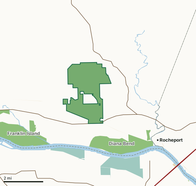
MDC conservation areasNational wildlife refugesState parks and historic sitesDavisdale Conservation AreaCounty lineLakeHighway
| Size | 2,784 acres |
|---|---|
| County | Howard County |
| Deer harvest unit | Howard County |
| MDC lists for hunting | Deer, Turkey, Rabbit, Squirrel, Dove and Quail |
| MDC area number | 8229 |
| MDC region | Central |
| Camping (MDC) | designated camping sites |
| Nearest towns | Rocheport (3 mi), New Franklin (5 mi) and Franklin (6 mi) |
What is Davisdale Conservation Area like?
Davisdale Conservation Area is in Howard County, 15 miles west of Columbia and seven miles east of Boonville on Highway 40. This 2,701-acre area features over 800 acres of riverhills woodland, which includes pecan and walnut, large tracts of warm- and cool-season grasses, interspersed with old fields, legumes and shrubs. A variety of crops are planted in rotation on about 300 acres of the area. Some grain is left unharvested as winter food for wildlife. Davisdale features a series of scenic limestone bluffs carved by the Missouri River, which now flows 1.5 miles away. Before its purchase by the Conservation Department in 1981, Davisdale was one of the larger single-family holdings in Howard County. It was actually a collection of several small farms, with more than a dozen homes. Bricks for some of the structures were cast from clay mined on the area. The early English settlers maintained livestock and planted wheat, oats and corn, as well as tobacco, in the deep loess soils. At one time, Howard County led the state in tobacco production. Soil conservation practices, including contour terraces, catch basins, limited tillage and crop rotation, instituted by the early settlers are still practiced today. Legumes and native grasses are planted to control erosion and replace less desirable grasses, such as tall fescue.
Fishing regulations: Pole and Line Fishing Only (Max. 3 poles/person); Largemouth Bass daily limit - 6 with 12-15 protected slot length; Crappie daily limit 30; Channel Catfish daily limit 4; All other fish combined daily limit 20.
In MDC's words, from the Davisdale Conservation Area page.
What can you hunt on Davisdale Conservation Area?
MDC's page for Davisdale Conservation Area lists: Deer: archery only, antlerless permits allowed; Turkey: archery and firearms; Rabbit; Squirrel; Dove; Quail.
What are the rules on Davisdale Conservation Area?
Dove Hunting: Use or possession of lead shot is prohibited for hunting doves on this area.
Every conservation area also follows MDC's standard rules in Chapter 11 of the Wildlife Code; the area's full rules are on MDC's site.
How many deer are taken around Davisdale Conservation Area?
Davisdale Conservation Area lies in Howard County. Hunters checked 2,304 deer in Howard County in 2025, against 2,077 in 2024.
| County | Davisdale Conservation Area acres in it | Deer, 2025 | Deer, 2024 | Deer, 2023 |
|---|---|---|---|---|
| Howard County | 2,784 | 2,304 | 2,077 | 2,441 |
Harvest for the whole county, not the conservation area alone: MDC deer harvest summaries (2021 to 2025 seasons).
How do you get to Davisdale Conservation Area?
MDC's directions: From Columbia, take I-70 west, take Highway 40 west 12 miles and watch for area sign. From Boonville take Highway 40 east for 7 miles.
Nearest towns: Rocheport (3 miles), New Franklin (5 miles), Franklin (6 miles) and Windsor Place (6 miles). Highways within 5 miles: I-70, US 40, MO 98, MO 240 and MO 87.
What other public land is near Davisdale Conservation Area?
MDC lands within 10 miles:
- Diana Bend Conservation Area: 1,342 acres, 0.6 miles away
- Franklin Island Conservation Area: 1,668 acres, 1.7 miles away
- Moniteau Creek Conservation Area: 744 acres, 3.5 miles away
- D. C. Rogers Lake (Fayette): 203 acres, 8.9 miles away
- Huntsdale Access: 20 acres, 9.5 miles away
Public land within 3 miles of Davisdale Conservation Area
Counting Davisdale Conservation Area itself, 6,291 of the 39,474 acres within 3 miles of its boundary are public land open to the public (15.9%), by USGS PAD-US 4.1 and MDC conservation area boundaries.
| Manager | Acres within 3 miles |
|---|---|
| MDC conservation areas | 5,125 |
| National wildlife refuges | 1,161 |
| State parks and historic sites | 5 |
Questions hunters ask
Where is Davisdale Conservation Area?
In Howard County, 3 miles from Rocheport.
Can you deer hunt on Davisdale Conservation Area?
Yes, by MDC's page: archery only, antlerless permits allowed.
How much public land is around Davisdale Conservation Area?
6,291 acres within 3 miles of its boundary, Davisdale Conservation Area included, by USGS PAD-US 4.1 and MDC conservation area boundaries. The closest other MDC area is Diana Bend Conservation Area (0.6 miles).
Get a Missouri hunt plan when they open
Hunt plans for Missouri are coming. Join the list and you'll hear first. The first 50 hunters in each new state get their plan free.
Until then, the free FilledTag app for iPhone has a map that works in every state, Missouri included.
Where these facts come from
- Area description, species, rules and directions: MDC, Davisdale Conservation Area; MDC conservation area boundaries.
- Boundary and acres: MDC's map layer above. Surrounding public land: USGS PAD-US 4.1 (fee land open to the public) and MDC conservation area boundaries.
- Deer harvest: MDC deer harvest summaries (2021 to 2025 seasons).
FilledTag is not part of the Missouri Department of Conservation. Check MDC's rules and posted signs before you go.