Diana Bend Conservation Area: hunting and access
Diana Bend Conservation Area is 1,342 acres of MDC land in Howard County, next to Rocheport. MDC lists deer hunting here (archery and firearms, antlerless permits allowed). Hunters checked 2,304 deer in Howard County in 2025.
Data updated October 2026. Area facts: MDC's conservation area data, read 2026-10. Harvest: MDC deer harvest summaries, 2021 to 2025.
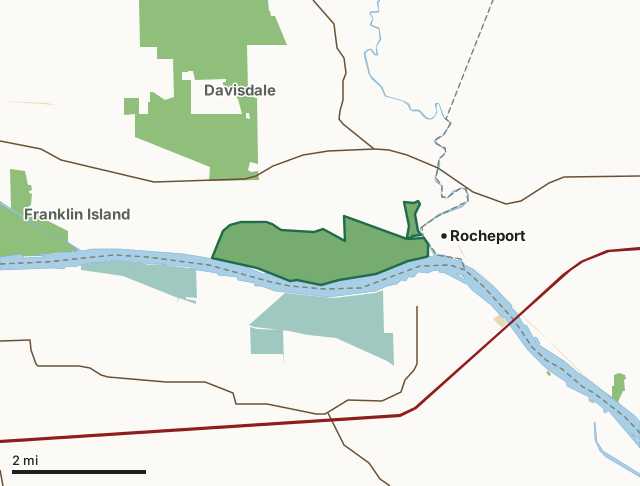
MDC conservation areasNational wildlife refugesState parks and historic sitesDiana Bend Conservation AreaCounty lineLakeHighway
| Size | 1,342 acres in 2 pieces |
|---|---|
| County | Howard County |
| Deer harvest unit | Howard County |
| MDC lists for hunting | Deer, Turkey, Rabbit, Dove and Quail |
| MDC area number | 9710 |
| MDC region | Central |
| Camping (MDC) | designated camping sites and boat-in along missouri river |
| Nearest towns | Rocheport (next to it), Windsor Place (5 mi) and Wooldridge (5 mi) |
What is Diana Bend Conservation Area like?
This 1,343-acre area is bounded on the south by the Missouri River, on the east by Moniteau Creek, on the north by the Katy Trail, and on the west by a levee. Diana Bend Conservation Area is subject to seasonal flooding. Two water control structures help control opportunistic flooding, but no pumps have been installed. Vegetation is dependent on river fluctuations. The area may contain up to 400 acres of water less than two feet deep, which can provide excellent waterfowl hunting opportunities when conditons allow. The Missouri River and Moniteau Creek provide good fishing, but visitors need a boat to access them. A three-acre blue hole on the west portion of the area provides walk-in fishing. In the past, this area was intensively farmed. About 30 percent of the area is now regenerating cottonwoods and willows. Bottomland hardwood trees were planted in 1998. The Conservation Department continues to plant about 15 percent of the area in annual crops, all of which are left unharvested to provide food for wildlife. A 100-acre semi-permanent marsh has been developed adjacent to the Katy Trail. A disabled accessible wildlife viewing blind exists at the base of the bluffs just west of Rocheport. A viewing platform also offers a commanding view of the floodplain from atop the bluffs. Primative camping is allowed along the Missouri River and in a designated parking lot.
In MDC's words, from the Diana Bend Conservation Area page.
What can you hunt on Diana Bend Conservation Area?
MDC's page for Diana Bend Conservation Area lists: Deer: archery and firearms, antlerless permits allowed; Turkey: archery and firearms; Rabbit; Dove; Quail.
What are the rules on Diana Bend Conservation Area?
Hunting: Nontoxic shot is required for all hunting with a shotgun on this area. Use or possession of lead shot is prohibited.
Every conservation area also follows MDC's standard rules in Chapter 11 of the Wildlife Code; the area's full rules are on MDC's site.
How many deer are taken around Diana Bend Conservation Area?
Diana Bend Conservation Area lies in Howard County. Hunters checked 2,304 deer in Howard County in 2025, against 2,077 in 2024.
| County | Diana Bend Conservation Area acres in it | Deer, 2025 | Deer, 2024 | Deer, 2023 |
|---|---|---|---|---|
| Howard County | 1,342 | 2,304 | 2,077 | 2,441 |
Harvest for the whole county, not the conservation area alone: MDC deer harvest summaries (2021 to 2025 seasons).
How do you get to Diana Bend Conservation Area?
MDC's directions: Diana Bend Conservation Area is in Howard County, about five miles east of Boonville off of Highway 40. To reach the area from I-70 at Columbia, travel west and take the Midway Exit onto Highway 40. Drive 11 miles to the welcome sign on the left. The area, which is adjacent to the Missouri River is 0.625 mile down a gravel road.
Nearest towns: Rocheport (next to it), Windsor Place (5 miles), Wooldridge (5 miles) and Boonville (6 miles). Highways within 5 miles: I-70, US 40, MO 98, MO 179 and MO 240.
What other public land is near Diana Bend Conservation Area?
MDC lands within 10 miles:
- Davisdale Conservation Area: 2,784 acres, 0.6 miles away
- Franklin Island Conservation Area: 1,668 acres, 2 miles away
- Huntsdale Access: 20 acres, 6.8 miles away
- Moniteau Creek Conservation Area: 744 acres, 6.9 miles away
- Eagle Bluffs Conservation Area: 4,596 acres, 8.5 miles away
Public land within 3 miles of Diana Bend Conservation Area
Counting Diana Bend Conservation Area itself, 4,833 of the 34,322 acres within 3 miles of its boundary are public land open to the public (14.1%), by USGS PAD-US 4.1 and MDC conservation area boundaries.
| Manager | Acres within 3 miles |
|---|---|
| MDC conservation areas | 3,581 |
| National wildlife refuges | 1,233 |
| State parks and historic sites | 19 |
Questions hunters ask
Where is Diana Bend Conservation Area?
In Howard County, next to Rocheport.
Can you deer hunt on Diana Bend Conservation Area?
Yes, by MDC's page: archery and firearms, antlerless permits allowed.
How much public land is around Diana Bend Conservation Area?
4,833 acres within 3 miles of its boundary, Diana Bend Conservation Area included, by USGS PAD-US 4.1 and MDC conservation area boundaries. The closest other MDC area is Davisdale Conservation Area (0.6 miles).
Get a Missouri hunt plan when they open
Hunt plans for Missouri are coming. Join the list and you'll hear first. The first 50 hunters in each new state get their plan free.
Until then, the free FilledTag app for iPhone has a map that works in every state, Missouri included.
Where these facts come from
- Area description, species, rules and directions: MDC, Diana Bend Conservation Area; MDC conservation area boundaries.
- Boundary and acres: MDC's map layer above. Surrounding public land: USGS PAD-US 4.1 (fee land open to the public) and MDC conservation area boundaries.
- Deer harvest: MDC deer harvest summaries (2021 to 2025 seasons).
FilledTag is not part of the Missouri Department of Conservation. Check MDC's rules and posted signs before you go.