Eagle Bluffs Conservation Area: hunting and access
Eagle Bluffs Conservation Area is 4,596 acres of MDC land in Boone County, next to McBaine. MDC lists deer hunting here (archery only, antlerless permits allowed). Hunters checked 3,439 deer in Boone County in 2025.
Data updated October 2026. Area facts: MDC's conservation area data, read 2026-10. Harvest: MDC deer harvest summaries, 2021 to 2025.
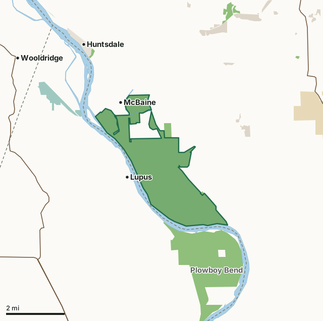
MDC conservation areasNational wildlife refugesState parks and historic sitesCounty, city and regional landLand trusts and other open landEagle Bluffs Conservation AreaCounty lineLakeHighway
| Size | 4,596 acres |
|---|---|
| County | Boone County |
| Deer harvest unit | Boone County |
| MDC lists for hunting | Deer, Turkey and Dove |
| MDC area number | 8931 |
| MDC region | Central |
| Camping (MDC) | boat-in along missouri river |
| Nearest towns | McBaine (next to it), Lupus (next to it) and Huntsdale (2 mi) |
What is Eagle Bluffs Conservation Area like?
Eagle Bluffs Conservation Area is in Boone County at the southwest edge of Columbia, near McBaine. The Missouri River and Perche Creek provide over 10 miles of stream frontage on Eagle Bluffs. Through the years, the Missouri River has changed its course many times. The town of Providence, across Perche Creek from Eagle Bluffs, was once on the bank of the Missouri, before the river changed its course in the late 1800's. Providence is now almost a mile north of the river. The Missouri once flowed through what is now Eagle Bluffs and sunk the steamship Plowboy, which is now believed to be buried under sand and silt on the area. The Conservation Department purchased and developed this 4,431-acre area to help offset the loss of nearly 90 percent of Missouri's historical wetlands. The area's wetlands have been restored by creating 17 shallow pools. The wetland management infrastructure includes 30 miles of levees, 61 water control structures, river water supply pumps, a water supply junction box, pump-out facilities, and a pipeline linking the area to the City of Columbia's wastewater treatment wetlands. The City of Columbia and the Department of Conservation entered into a cooperative agreement that allows the Department to use treated wastewater from the city as a primary water source for the wetlands. The city's recycled wastewater provides a near constant source of water, but river pumps can supplement the water supply when the area's needs exceed the flow from the city. The area's 17 wetland pools allow the flooding of 1,100 acres of moist soil marshes, emergent marshes, and crop fields. These marshes provide year-round habitat for migrating and wintering birds and permanent wildlife and excellent wildlife viewing and hunting opportunities. In the fall, the area's beauty is enhanced by colorful foliage along the bordering limestone bluffs. The KATY Trail State Park passes through a portion of the area and adds to the public's use and enjoyment of Eagle Bluffs Conservation Area. The parking lot located on Warren School Road provides walking access to a small portion of upland forest that overlooks the wetlands.
Fishing regulations: Statewide regulations apply.
In MDC's words, from the Eagle Bluffs Conservation Area page.
What can you hunt on Eagle Bluffs Conservation Area?
MDC's page for Eagle Bluffs Conservation Area lists: Deer: archery only, antlerless permits allowed; Turkey: archery only; Dove.
What are the rules on Eagle Bluffs Conservation Area?
Closings: Portions of this department area are closed to protect waterfowl from October 15 through March 1.
Camping: Camping is allowed by Missouri River boat travelers within 100 yards of the river between April 1 and Sept. 30. All other camping is prohibited.
Hunting: Nontoxic shot is required for all hunting with a shotgun on this area. Use or possession of lead shot is prohibited.
Field Trials: Field trials are allowed on this department area only by special use permit. To obtain a special use permit, contact the area manager at the phone number listed for this area in the area details section.
Waterfowl Hunting: Waterfowl hunting is prohibited after 1:00 p.m. on designated portions of this area (one of several MDC lists for this rule).
Every conservation area also follows MDC's standard rules in Chapter 11 of the Wildlife Code; the area's full rules are on MDC's site.
How many deer are taken around Eagle Bluffs Conservation Area?
Eagle Bluffs Conservation Area lies in Boone County. Hunters checked 3,439 deer in Boone County in 2025, against 3,174 in 2024.
| County | Eagle Bluffs Conservation Area acres in it | Deer, 2025 | Deer, 2024 | Deer, 2023 |
|---|---|---|---|---|
| Boone County | 4,596 | 3,439 | 3,174 | 3,644 |
Harvest for the whole county, not the conservation area alone: MDC deer harvest summaries (2021 to 2025 seasons).
How do you get to Eagle Bluffs Conservation Area?
MDC's directions: From Columbia, take Providence Road (Route K) south past the village of McBaine. Continue across Perche Creek and turn left on Star School Road.
Nearest towns: McBaine (next to it), Lupus (next to it), Huntsdale (2 miles) and Wooldridge (3 miles). Highways within 5 miles: MO 179, MO 87 and MO 163.
What other public land is near Eagle Bluffs Conservation Area?
MDC lands within 10 miles:
- Plowboy Bend Conservation Area: 2,678 acres, next to it
- Huntsdale Access: 20 acres, 1.8 miles away
- Hinkson Woods Conservation Area: 81 acres, 3.5 miles away
- Three Creeks Conservation Area: 1,621 acres, 3.9 miles away
- Marion Bottoms Conservation Area: 2,943 acres, 5.7 miles away
Public land within 3 miles of Eagle Bluffs Conservation Area
Counting Eagle Bluffs Conservation Area itself, 7,845 of the 50,717 acres within 3 miles of its boundary are public land open to the public (15.5%), by USGS PAD-US 4.1 and MDC conservation area boundaries.
| Manager | Acres within 3 miles |
|---|---|
| MDC conservation areas | 7,319 |
| National wildlife refuges | 261 |
| Land trusts and other open land | 142 |
| County, city and regional land | 116 |
| State parks and historic sites | 7 |
Questions hunters ask
Where is Eagle Bluffs Conservation Area?
In Boone County, next to McBaine.
Can you deer hunt on Eagle Bluffs Conservation Area?
Yes, by MDC's page: archery only, antlerless permits allowed.
How much public land is around Eagle Bluffs Conservation Area?
7,845 acres within 3 miles of its boundary, Eagle Bluffs Conservation Area included, by USGS PAD-US 4.1 and MDC conservation area boundaries. The closest other MDC area is Plowboy Bend Conservation Area (next to it).
Get a Missouri hunt plan when they open
Hunt plans for Missouri are coming. Join the list and you'll hear first. The first 50 hunters in each new state get their plan free.
Until then, the free FilledTag app for iPhone has a map that works in every state, Missouri included.
Where these facts come from
- Area description, species, rules and directions: MDC, Eagle Bluffs Conservation Area; MDC conservation area boundaries.
- Boundary and acres: MDC's map layer above. Surrounding public land: USGS PAD-US 4.1 (fee land open to the public) and MDC conservation area boundaries.
- Deer harvest: MDC deer harvest summaries (2021 to 2025 seasons).
FilledTag is not part of the Missouri Department of Conservation. Check MDC's rules and posted signs before you go.