Three Creeks Conservation Area: hunting and access
Three Creeks Conservation Area is 1,621 acres of MDC land in Boone County, next to Pierpont. MDC lists deer hunting here (archery and firearms, archery antlerless permits only). Hunters checked 3,439 deer in Boone County in 2025.
Data updated October 2026. Area facts: MDC's conservation area data, read 2026-10. Harvest: MDC deer harvest summaries, 2021 to 2025.
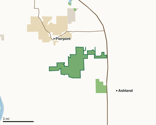
MDC conservation areasState parks and historic sitesCounty, city and regional landThree Creeks Conservation AreaCounty lineLakeHighway
| Size | 1,621 acres in 2 pieces |
|---|---|
| County | Boone County |
| Deer harvest unit | Boone County |
| MDC lists for hunting | Deer, Turkey, Rabbit and Squirrel |
| MDC area number | 8315 |
| MDC region | Central |
| Camping (MDC) | walk-in, float-in or backpack camping (not during deer and turkey seasons) |
| Nearest towns | Pierpont (next to it), Ashland (2 mi) and Columbia (7 mi) |
What is Three Creeks Conservation Area like?
Three Creeks Conservation Area is in Boone County (halfway between Columbia and Ashland). The area takes its name from the three creeks that run through the area: Turkey Creek, Bass Creek, and Bonne Femme Creek. The rugged forest features scenic bluffs, intermittent streams, geologic formations, and old eastern red cedar trees. Three Creeks Conservation Area was considered for purchase as a result of substantial public input and interest in protecting the general Three Creeks area from further urban development, which would destroy its appearance and natural features. Moreover, Three Creeks Conservation Area was acquired to maintain and manage representative plant and animal communities and to provide outdoor recreational and educational opportunities in an urbanizing region of central Missouri. Much of the land in the general area was purchased by freed slaves following the Civil War. Generally, the tracts were small (usually 40 or 80 acre parcels). Land which could be seeded to pasture for grazing or plowed with a horse was farmed into the 1930's when many families could no longer support themselves on the small tracts of land. Many had to sell their property due to the economic conditions during the Depression. The reduction in the number of landowners has continued up to the present time. Seven identifiable house sites have been located on the initial 685 acres.
The Waters-Russell that holds the Boone County Nature School is closed to general public use and is only accessible through Special Use Permit. The Boone County Nature School is a public school entity and a partnership between Columbia Public Schools and the Missouri Department of Conservation. Any individual or group wishing to participate in activities on the Boone County Nature School campus, including daily or overnight use, must first complete and receive approval through a Special Use Permit application. Activities are not permitted without an approved application, and access is granted only as outlined in the permit. For more detailed information about the Boone County Nature School, please visit: www.boonecountynatureschool.com/about/our-campus/ To apply for a Special Use Permit, please visit: www.boonecountynatureschool.com/special-use-permit/ Special Use Permit - Boone County...
In MDC's words, from the Three Creeks Conservation Area page.
What can you hunt on Three Creeks Conservation Area?
MDC's page for Three Creeks Conservation Area lists: Deer: archery and firearms, archery antlerless permits only; Turkey: archery and firearms; Rabbit; Squirrel.
What are the rules on Three Creeks Conservation Area?
MDC's standard conservation area rules (Chapter 11 of the Wildlife Code) apply; the area's rules on MDC's site list any it adds.
How many deer are taken around Three Creeks Conservation Area?
Three Creeks Conservation Area lies in Boone County. Hunters checked 3,439 deer in Boone County in 2025, against 3,174 in 2024.
| County | Three Creeks Conservation Area acres in it | Deer, 2025 | Deer, 2024 | Deer, 2023 |
|---|---|---|---|---|
| Boone County | 1,621 | 3,439 | 3,174 | 3,644 |
Harvest for the whole county, not the conservation area alone: MDC deer harvest summaries (2021 to 2025 seasons).
How do you get to Three Creeks Conservation Area?
MDC's directions: From Columbia, take Highway 63 south 5 miles, then Deer Park Road west 1.75 miles.
Nearest towns: Pierpont (next to it), Ashland (2 miles), Columbia (7 miles) and Lupus (7 miles). Highways within 5 miles: US 63 and MO 163.
What other public land is near Three Creeks Conservation Area?
MDC lands within 10 miles:
- A. Perry Philips Park Lake (Columbia): 41 acres, 2.7 miles away
- Plowboy Bend Conservation Area: 2,678 acres, 3.8 miles away
- Eagle Bluffs Conservation Area: 4,596 acres, 3.9 miles away
- Henry Jackson Waters and C. B. Moss Memorial Wildlife Area: 110 acres, 4.8 miles away
Public land within 3 miles of Three Creeks Conservation Area
Counting Three Creeks Conservation Area itself, 4,223 of the 38,261 acres within 3 miles of its boundary are public land open to the public (11%), by USGS PAD-US 4.1 and MDC conservation area boundaries.
| Manager | Acres within 3 miles |
|---|---|
| MDC conservation areas | 2,001 |
| State parks and historic sites | 1,926 |
| County, city and regional land | 296 |
Questions hunters ask
Where is Three Creeks Conservation Area?
In Boone County, next to Pierpont.
Can you deer hunt on Three Creeks Conservation Area?
Yes, by MDC's page: archery and firearms, archery antlerless permits only.
How much public land is around Three Creeks Conservation Area?
4,223 acres within 3 miles of its boundary, Three Creeks Conservation Area included, by USGS PAD-US 4.1 and MDC conservation area boundaries. The closest other MDC area is A. Perry Philips Park Lake (Columbia) (2.7 miles).
Get a Missouri hunt plan when they open
Hunt plans for Missouri are coming. Join the list and you'll hear first. The first 50 hunters in each new state get their plan free.
Until then, the free FilledTag app for iPhone has a map that works in every state, Missouri included.
Where these facts come from
- Area description, species, rules and directions: MDC, Three Creeks Conservation Area; MDC conservation area boundaries.
- Boundary and acres: MDC's map layer above. Surrounding public land: USGS PAD-US 4.1 (fee land open to the public) and MDC conservation area boundaries.
- Deer harvest: MDC deer harvest summaries (2021 to 2025 seasons).
FilledTag is not part of the Missouri Department of Conservation. Check MDC's rules and posted signs before you go.