Plowboy Bend Conservation Area: hunting and access
Plowboy Bend Conservation Area is 2,678 acres of MDC land in Moniteau County, 2 miles from Lupus. MDC lists deer hunting here (archery and firearms, archery antlerless permits only). Hunters checked 1,822 deer in Moniteau County in 2025.
Data updated October 2026. Area facts: MDC's conservation area data, read 2026-10. Harvest: MDC deer harvest summaries, 2021 to 2025.
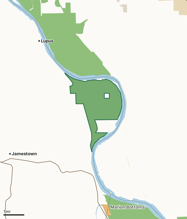
MDC conservation areasState parks and historic sitesCounty, city and regional landMRAP landPlowboy Bend Conservation AreaCounty lineLakeHighway
| Size | 2,678 acres |
|---|---|
| County | Moniteau County |
| Deer harvest unit | Moniteau County |
| MDC lists for hunting | Deer, Bear, Turkey, Rabbit, Dove and Quail |
| MDC area number | 9530 |
| MDC region | Central |
| Camping (MDC) | designated camping sites and boat-in along missouri river |
| Nearest towns | Lupus (2 mi), Jamestown (4 mi) and McBaine (4 mi) |
What is Plowboy Bend Conservation Area like?
Plowboy Bend Conservation Area in Moniteau County is located five miles northeast of Jamestown. To reach the area take Highway 179, into Jamestown, turn north on Route Y and proceed five miles until the pavement ends. Turn right onto Riverbottom Rd. and follow it across the railroad track into the 2,617-acre area.
The Missouri River forms the northern and eastern boundaries of the Area and provides over five miles of river frontage. The Area takes its name from the bend in the Missouri River at the north end of the Area, named for the steamboat Plowboy that sunk nearby in the mid 1800's. The site was acquired by the Conservation Department in 1995, bought in part with federal funds provided by the Partnership for Missouri Riverlands; a consortium of state and federal agencies formed after the 1993 flood to negotiate purchase of flood prone land in order to lessen the chance and severity of future floods. The Area contains riparian forests, old fields, successional forests, wetlands, and croplands. There is also an old river slough and forested bluffs in the northwest portion of the area. Management emphasizes bottomland forest creation, reestablishing mast-producing trees, and creating...
In MDC's words, from the Plowboy Bend Conservation Area page.
What can you hunt on Plowboy Bend Conservation Area?
MDC's page for Plowboy Bend Conservation Area lists: Deer: archery and firearms, archery antlerless permits only; Bear: archery and firearms; Turkey: archery and firearms; Rabbit; Dove; Quail.
What are the rules on Plowboy Bend Conservation Area?
Hunting: Nontoxic shot is required for all hunting with a shotgun on this area. Use or possession of lead shot is prohibited.
Every conservation area also follows MDC's standard rules in Chapter 11 of the Wildlife Code; the area's full rules are on MDC's site.
How many deer are taken around Plowboy Bend Conservation Area?
Plowboy Bend Conservation Area lies in Moniteau County. Hunters checked 1,822 deer in Moniteau County in 2025, against 1,693 in 2024.
| County | Plowboy Bend Conservation Area acres in it | Deer, 2025 | Deer, 2024 | Deer, 2023 |
|---|---|---|---|---|
| Moniteau County | 2,678 | 1,822 | 1,693 | 1,948 |
Harvest for the whole county, not the conservation area alone: MDC deer harvest summaries (2021 to 2025 seasons).
How do you get to Plowboy Bend Conservation Area?
MDC's directions: From Jamestown, take Route Y north 5 miles to end of pavement, continue on Riverbottom Road east 0.50 mile crossing railroad tracks to area.
Nearest towns: Lupus (2 miles), Jamestown (4 miles), McBaine (4 miles) and Pierpont (5 miles). Highways within 5 miles: MO 179 and MO 87. 1 MRAP tract within 3 miles.
What other public land is near Plowboy Bend Conservation Area?
MDC lands within 10 miles:
- Eagle Bluffs Conservation Area: 4,596 acres, next to it
- Marion Bottoms Conservation Area: 2,943 acres, 2.1 miles away
- Three Creeks Conservation Area: 1,621 acres, 3.8 miles away
- Hart Creek Conservation Area: 659 acres, 5.1 miles away
- Hartsburg Access: 36 acres, 5.4 miles away
- Huntsdale Access: 20 acres, 6.1 miles away
Public land within 3 miles of Plowboy Bend Conservation Area
Counting Plowboy Bend Conservation Area itself, 6,580 of the 41,380 acres within 3 miles of its boundary are public land open to the public (15.9%), by USGS PAD-US 4.1 and MDC conservation area boundaries.
| Manager | Acres within 3 miles |
|---|---|
| MDC conservation areas | 6,574 |
| State parks and historic sites | 6 |
Questions hunters ask
Where is Plowboy Bend Conservation Area?
In Moniteau County, 2 miles from Lupus.
Can you deer hunt on Plowboy Bend Conservation Area?
Yes, by MDC's page: archery and firearms, archery antlerless permits only.
How much public land is around Plowboy Bend Conservation Area?
6,580 acres within 3 miles of its boundary, Plowboy Bend Conservation Area included, by USGS PAD-US 4.1 and MDC conservation area boundaries. The closest other MDC area is Eagle Bluffs Conservation Area (next to it).
Get a Missouri hunt plan when they open
Hunt plans for Missouri are coming. Join the list and you'll hear first. The first 50 hunters in each new state get their plan free.
Until then, the free FilledTag app for iPhone has a map that works in every state, Missouri included.
Where these facts come from
- Area description, species, rules and directions: MDC, Plowboy Bend Conservation Area; MDC conservation area boundaries.
- Boundary and acres: MDC's map layer above. Surrounding public land: USGS PAD-US 4.1 (fee land open to the public) and MDC conservation area boundaries.
- Deer harvest: MDC deer harvest summaries (2021 to 2025 seasons).
FilledTag is not part of the Missouri Department of Conservation. Check MDC's rules and posted signs before you go.