Marion Bottoms Conservation Area: hunting and access
Marion Bottoms Conservation Area is 2,943 acres of MDC land in Cole and Moniteau counties, 2 miles from Hartsburg. MDC lists deer hunting here (archery and firearms, antlerless permits allowed). Hunters checked 2,029 deer in Cole County in 2025.
Data updated October 2026. Area facts: MDC's conservation area data, read 2026-10. Harvest: MDC deer harvest summaries, 2021 to 2025.
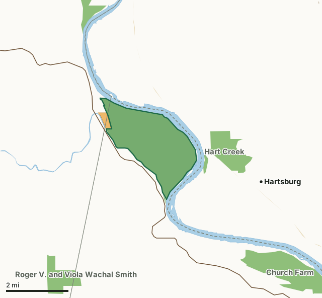
MDC conservation areasState parks and historic sitesCounty, city and regional landMRAP landMarion Bottoms Conservation AreaCounty lineLakeHighway
| Size | 2,943 acres |
|---|---|
| Counties | Cole County and Moniteau County |
| Deer harvest unit | Cole County, Moniteau County |
| MDC lists for hunting | Deer, Bear, Turkey and Rabbit |
| MDC area number | 9632 |
| MDC region | Central |
| Camping (MDC) | designated camping sites and boat-in along missouri river |
| Nearest towns | Hartsburg (2 mi), Jamestown (5 mi) and Centertown (6 mi) |
What is Marion Bottoms Conservation Area like?
Marion Bottoms Conservation Area, in Cole County, is located two miles north of Marion, MO on Moniteau Creek road off of Highway 179.
The 2,997-acre area was purchased in 1996 and is surrounded by the Missouri River on the north, east, and south boundaries, providing six miles of river frontage. The site was acquired by the Conservation Department in 1996, bought in part with funds provided by the federal government after the 1993 flood to negotiate purchase of flood prone land in order to lessen the chance and severity of future floods. The area includes riparian and successional forests, old fields, marshes, several blue holes, and several hundred acres of wetland that include areas of open water, and seasonally flooded vegetation, and flooded forest. The wetlands, blue holes, and riverine habitats provide valuable habitat for fish, waterfowl, shorebirds, and amphibians. As successional forests, dominated by cottonwood and willow, develop into mature, bottomland forests, habitat for turkey and other small game will...
In MDC's words, from the Marion Bottoms Conservation Area page.
What can you hunt on Marion Bottoms Conservation Area?
MDC's page for Marion Bottoms Conservation Area lists: Deer: archery and firearms, antlerless permits allowed; Bear: archery and firearms; Turkey: archery and firearms; Rabbit.
What are the rules on Marion Bottoms Conservation Area?
Hunting: Nontoxic shot is required for all hunting with a shotgun on this area. Use or possession of lead shot is prohibited.
Every conservation area also follows MDC's standard rules in Chapter 11 of the Wildlife Code; the area's full rules are on MDC's site.
How many deer are taken around Marion Bottoms Conservation Area?
Marion Bottoms Conservation Area lies in 2 counties. Hunters checked 2,029 deer in Cole County in 2025, against 1,866 in 2024.
| County | Marion Bottoms Conservation Area acres in it | Deer, 2025 | Deer, 2024 | Deer, 2023 |
|---|---|---|---|---|
| Cole County | 2,896 | 2,029 | 1,866 | 2,049 |
| Moniteau County | 47 | 1,822 | 1,693 | 1,948 |
Harvest for the whole county, not the conservation area alone: MDC deer harvest summaries (2021 to 2025 seasons).
How do you get to Marion Bottoms Conservation Area?
MDC's directions: From Marion, take Highway 179 north 3.50 miles, take Moniteau Creek Road (first road north of Moniteau Creek) east to the area. There is currently only one way in and out of the area.
Nearest towns: Hartsburg (2 miles), Jamestown (5 miles), Centertown (6 miles) and St. Martins (7 miles). Highways within 5 miles: MO 179, US 63 and MO 87. 1 MRAP tract within 3 miles.
What other public land is near Marion Bottoms Conservation Area?
MDC lands within 10 miles:
- Hartsburg Access: 36 acres, next to it
- Hart Creek Conservation Area: 659 acres, 0.5 miles away
- Plowboy Bend Conservation Area: 2,678 acres, 2.1 miles away
- Church Farm Conservation Area: 1,254 acres, 3 miles away
- Roger V. and Viola Wachal Smith Conservation Area: 484 acres, 3.7 miles away
- Eagle Bluffs Conservation Area: 4,596 acres, 5.7 miles away
Public land within 3 miles of Marion Bottoms Conservation Area
Counting Marion Bottoms Conservation Area itself, 3,818 of the 39,746 acres within 3 miles of its boundary are public land open to the public (9.6%), by USGS PAD-US 4.1 and MDC conservation area boundaries.
| Manager | Acres within 3 miles |
|---|---|
| MDC conservation areas | 3,811 |
| State parks and historic sites | 7 |
Questions hunters ask
Where is Marion Bottoms Conservation Area?
In Cole and Moniteau counties, 2 miles from Hartsburg.
Can you deer hunt on Marion Bottoms Conservation Area?
Yes, by MDC's page: archery and firearms, antlerless permits allowed.
How much public land is around Marion Bottoms Conservation Area?
3,818 acres within 3 miles of its boundary, Marion Bottoms Conservation Area included, by USGS PAD-US 4.1 and MDC conservation area boundaries. The closest other MDC area is Hartsburg Access (next to it).
Get a Missouri hunt plan when they open
Hunt plans for Missouri are coming. Join the list and you'll hear first. The first 50 hunters in each new state get their plan free.
Until then, the free FilledTag app for iPhone has a map that works in every state, Missouri included.
Where these facts come from
- Area description, species, rules and directions: MDC, Marion Bottoms Conservation Area; MDC conservation area boundaries.
- Boundary and acres: MDC's map layer above. Surrounding public land: USGS PAD-US 4.1 (fee land open to the public) and MDC conservation area boundaries.
- Deer harvest: MDC deer harvest summaries (2021 to 2025 seasons).
FilledTag is not part of the Missouri Department of Conservation. Check MDC's rules and posted signs before you go.