DeSoto Unit of Black Island Conservation Area: hunting and access
DeSoto Unit of Black Island Conservation Area is 737 acres of MDC land in Pemiscot County, 6 miles from Caruthersville. MDC lists deer hunting here (muzzleloader and archery, antlerless permits not allowed). Hunters checked 169 deer in Pemiscot County in 2025.
Data updated October 2026. Area facts: MDC's conservation area data, read 2026-10. Harvest: MDC deer harvest summaries, 2021 to 2025.
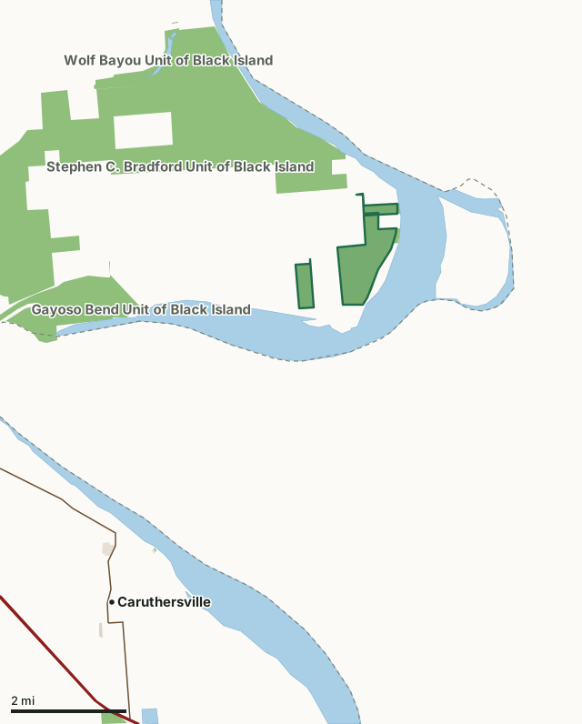
MDC conservation areasCounty, city and regional landLand trusts and other open landDeSoto Unit of Black Island Conservation AreaCounty lineLakeHighway
| Size | 737 acres in 2 pieces |
|---|---|
| County | Pemiscot County |
| Deer harvest unit | Pemiscot County |
| MDC lists for hunting | Deer, Turkey, Rabbit and Squirrel |
| MDC area number | 200013 |
| MDC region | Southeast |
| Nearest towns | Caruthersville (6 mi), Hayti (8 mi) and Hayti Heights (9 mi) |
What is DeSoto Unit of Black Island Conservation Area like?
The Desoto Unit of Black Island Conservation Area is located at the far southeast corner of Black Island. The topography is very flat and contains a combination of bottomland forest and old field type habitat. The forested portions of this unit are in various stages of succession as they were mostly in rowcrops in recent history. Some are young tree plantings, from 5-15 years old, while other portions were allowed to regenerate naturally. There are pockets of mature bottomland forest also.
Desoto Unit is directly affected by floodwaters of the Mississippi River. Portions of the unit receive almost annual flooding, but it is not uncommon for all but a handful of acres to be completely flooded. The topography that is present is the direct result of this flooding and is a testament to the power of the Mississippi River.With the diversity of bottomland forest, old field, and flooding patterns, a wide diversity of habitats exist on Desoto Unit, in turn supporting a diversity of plant and wildlife species. *All public use is prohibited, except fishing and waterfowl hunting by boat only, when the Mississippi River water level is at or above twenty eight (28) feet on the Caruthersville gauge. *Desoto Unit is comprised of three blocks. The middle block has access directly off County Road 338. The smaller North and West blocks are walk in access only from the county gravel road.
In MDC's words, from the DeSoto Unit of Black Island Conservation Area page.
What can you hunt on DeSoto Unit of Black Island Conservation Area?
MDC's page for DeSoto Unit of Black Island Conservation Area lists: Deer: muzzleloader and archery, antlerless permits not allowed; Turkey: archery and firearms; Rabbit; Squirrel.
What are the rules on DeSoto Unit of Black Island Conservation Area?
Closings: This department area is closed during periods of high water.
Hunting: Nontoxic shot is required for all hunting with a shotgun on this area. Use or possession of lead shot is prohibited.
Every conservation area also follows MDC's standard rules in Chapter 11 of the Wildlife Code; the area's full rules are on MDC's site.
How many deer are taken around DeSoto Unit of Black Island Conservation Area?
DeSoto Unit of Black Island Conservation Area lies in Pemiscot County. Hunters checked 169 deer in Pemiscot County in 2025, against 227 in 2024.
| County | DeSoto Unit of Black Island Conservation Area acres in it | Deer, 2025 | Deer, 2024 | Deer, 2023 |
|---|---|---|---|---|
| Pemiscot County | 737 | 169 | 227 | 220 |
Harvest for the whole county, not the conservation area alone: MDC deer harvest summaries (2021 to 2025 seasons).
How do you get to DeSoto Unit of Black Island Conservation Area?
MDC's directions: DeSoto Unit is off I-55 via the Wardell exit, then follow the eastbound outer road south to gravel road 330 and turn east. Take road 330 for 2 miles, then go over the levee on road 333 south for 2.50 miles, then left (east) on road 336 for 4.50 miles. When the road turns south, park and walk southeast for 0.25 mile.
Nearest towns: Caruthersville (6 miles), Hayti (8 miles), Hayti Heights (9 miles) and Hayward (9 miles).
What other public land is near DeSoto Unit of Black Island Conservation Area?
MDC lands within 10 miles:
- Stephen C. Bradford Unit of Black Island Conservation Area: 6,373 acres, next to it
- Gayoso Bend Unit of Black Island Conservation Area: 953 acres, 2.7 miles away
- Wolf Bayou Unit of Black Island Conservation Area: 349 acres, 3.9 miles away
- John L. and Georgia Girvin Conservation Area: 680 acres, 5.1 miles away
- Twin Borrow Pits Conservation Area: 74 acres, 6.4 miles away
Public land within 3 miles of DeSoto Unit of Black Island Conservation Area
Counting DeSoto Unit of Black Island Conservation Area itself, 2,879 of the 31,190 acres within 3 miles of its boundary are public land open to the public (9.2%), by USGS PAD-US 4.1 and MDC conservation area boundaries.
| Manager | Acres within 3 miles |
|---|---|
| MDC conservation areas | 2,879 |
Questions hunters ask
Where is DeSoto Unit of Black Island Conservation Area?
In Pemiscot County, 6 miles from Caruthersville.
Can you deer hunt on DeSoto Unit of Black Island Conservation Area?
Yes, by MDC's page: muzzleloader and archery, antlerless permits not allowed.
How much public land is around DeSoto Unit of Black Island Conservation Area?
2,879 acres within 3 miles of its boundary, DeSoto Unit of Black Island Conservation Area included, by USGS PAD-US 4.1 and MDC conservation area boundaries. The closest other MDC area is Stephen C. Bradford Unit of Black Island Conservation Area (next to it).
Get a Missouri hunt plan when they open
Hunt plans for Missouri are coming. Join the list and you'll hear first. The first 50 hunters in each new state get their plan free.
Until then, the free FilledTag app for iPhone has a map that works in every state, Missouri included.
Where these facts come from
- Area description, species, rules and directions: MDC, DeSoto Unit of Black Island Conservation Area; MDC conservation area boundaries.
- Boundary and acres: MDC's map layer above. Surrounding public land: USGS PAD-US 4.1 (fee land open to the public) and MDC conservation area boundaries.
- Deer harvest: MDC deer harvest summaries (2021 to 2025 seasons).
FilledTag is not part of the Missouri Department of Conservation. Check MDC's rules and posted signs before you go.