Gayoso Bend Unit of Black Island Conservation Area: hunting and access
Gayoso Bend Unit of Black Island Conservation Area is 953 acres of MDC land in Pemiscot County, 2 miles from Hayti. MDC lists deer hunting here (muzzleloader and archery, antlerless permits not allowed). Hunters checked 169 deer in Pemiscot County in 2025.
Data updated October 2026. Area facts: MDC's conservation area data, read 2026-10. Harvest: MDC deer harvest summaries, 2021 to 2025.
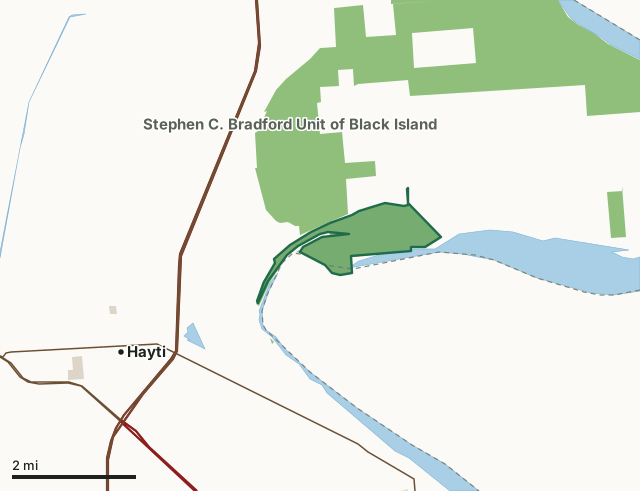
MDC conservation areasCounty, city and regional landLand trusts and other open landGayoso Bend Unit of Black Island Conservation AreaCounty lineLakeHighway
| Size | 953 acres in 2 pieces |
|---|---|
| County | Pemiscot County |
| Deer harvest unit | Pemiscot County |
| MDC lists for hunting | Deer, Turkey, Rabbit and Squirrel |
| MDC area number | 8613 |
| MDC region | Southeast |
| Nearest towns | Hayti (2 mi), Hayti Heights (3 mi) and Caruthersville (5 mi) |
What is Gayoso Bend Unit of Black Island Conservation Area like?
Gayoso Bend Conservation Area is located in Pemiscot County north of Caruthersville. It encompasses 968 acres of forestland, including 125 acres of wooded sloughs. The Mississippi River provides two miles of river frontage on the east side. The area is very flat with elevations ranging from 260-270 feet above mean sea level.
Rare plants and animals in the vicinity include primrose willow, saltmarsh aster, interior least tern, and cotton mouse. The Missouri Department of Conservation purchased the area in 1986. The town of Gayoso was located on or near the area. Its remains are buried deep in the silt. There are no structures or other artificial improvements on the area. Access is limited to a walk-in easement only. *All public use is prohibited, except fishing and waterfowl hunting by boat only, when the Mississippi River water level is at or above twenty eight (28) feet on the Caruthersville gauge.
In MDC's words, from the Gayoso Bend Unit of Black Island Conservation Area page.
What can you hunt on Gayoso Bend Unit of Black Island Conservation Area?
MDC's page for Gayoso Bend Unit of Black Island Conservation Area lists: Deer: muzzleloader and archery, antlerless permits not allowed; Turkey: archery and firearms; Rabbit; Squirrel.
What are the rules on Gayoso Bend Unit of Black Island Conservation Area?
Closings: This department area is closed during periods of high water.
Hunting: Nontoxic shot is required for all hunting with a shotgun on this area. Use or possession of lead shot is prohibited.
Every conservation area also follows MDC's standard rules in Chapter 11 of the Wildlife Code; the area's full rules are on MDC's site.
How many deer are taken around Gayoso Bend Unit of Black Island Conservation Area?
Gayoso Bend Unit of Black Island Conservation Area lies in Pemiscot County. Hunters checked 169 deer in Pemiscot County in 2025, against 227 in 2024.
| County | Gayoso Bend Unit of Black Island Conservation Area acres in it | Deer, 2025 | Deer, 2024 | Deer, 2023 |
|---|---|---|---|---|
| Pemiscot County | 925 | 169 | 227 | 220 |
Harvest for the whole county, not the conservation area alone: MDC deer harvest summaries (2021 to 2025 seasons).
How do you get to Gayoso Bend Unit of Black Island Conservation Area?
MDC's directions: Walk-in or boat-in area. This area can be accessed by boat along the Mississippi River or from Boat Club Chute. There is also a gravel boat slide on Stephen C. Bradford Unit that provides access to Gayoso Unit. During dry periods, it can be possible to walk into Gayoso Unit at the boat slide.
Nearest towns: Hayti (2 miles), Hayti Heights (3 miles), Caruthersville (5 miles) and Pascola (7 miles). Highways within 5 miles: I-55, US 61, US 412, MO 84 and I-155.
What other public land is near Gayoso Bend Unit of Black Island Conservation Area?
MDC lands within 10 miles:
- Stephen C. Bradford Unit of Black Island Conservation Area: 6,373 acres, next to it
- DeSoto Unit of Black Island Conservation Area: 737 acres, 2.7 miles away
- Wolf Bayou Unit of Black Island Conservation Area: 349 acres, 3 miles away
- John L. and Georgia Girvin Conservation Area: 680 acres, 7.9 miles away
- Twin Borrow Pits Conservation Area: 74 acres, 8.1 miles away
Public land within 3 miles of Gayoso Bend Unit of Black Island Conservation Area
Counting Gayoso Bend Unit of Black Island Conservation Area itself, 5,130 of the 33,617 acres within 3 miles of its boundary are public land open to the public (15.3%), by USGS PAD-US 4.1 and MDC conservation area boundaries.
| Manager | Acres within 3 miles |
|---|---|
| MDC conservation areas | 5,120 |
| County, city and regional land | 10 |
Questions hunters ask
Where is Gayoso Bend Unit of Black Island Conservation Area?
In Pemiscot County, 2 miles from Hayti.
Can you deer hunt on Gayoso Bend Unit of Black Island Conservation Area?
Yes, by MDC's page: muzzleloader and archery, antlerless permits not allowed.
How much public land is around Gayoso Bend Unit of Black Island Conservation Area?
5,130 acres within 3 miles of its boundary, Gayoso Bend Unit of Black Island Conservation Area included, by USGS PAD-US 4.1 and MDC conservation area boundaries. The closest other MDC area is Stephen C. Bradford Unit of Black Island Conservation Area (next to it).
Get a Missouri hunt plan when they open
Hunt plans for Missouri are coming. Join the list and you'll hear first. The first 50 hunters in each new state get their plan free.
Until then, the free FilledTag app for iPhone has a map that works in every state, Missouri included.
Where these facts come from
- Area description, species, rules and directions: MDC, Gayoso Bend Unit of Black Island Conservation Area; MDC conservation area boundaries.
- Boundary and acres: MDC's map layer above. Surrounding public land: USGS PAD-US 4.1 (fee land open to the public) and MDC conservation area boundaries.
- Deer harvest: MDC deer harvest summaries (2021 to 2025 seasons).
FilledTag is not part of the Missouri Department of Conservation. Check MDC's rules and posted signs before you go.