Edward Anderson Conservation Area: hunting and access
Edward Anderson Conservation Area is 1,067 acres of MDC land in Ralls and Pike counties, 3 miles from Saverton. MDC lists deer hunting here (archery and firearms, antlerless permits allowed). Hunters checked 2,742 deer in Ralls County in 2025.
Data updated October 2026. Area facts: MDC's conservation area data, read 2026-10. Harvest: MDC deer harvest summaries, 2021 to 2025.
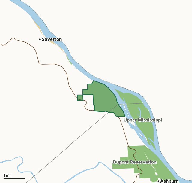
MDC conservation areasFederal land, mostly Corps of Engineers lakesEdward Anderson Conservation AreaCounty lineLakeHighway
| Size | 1,067 acres in 2 pieces |
|---|---|
| Counties | Ralls County and Pike County |
| Deer harvest unit | Ralls County, Pike County |
| MDC lists for hunting | Deer, Turkey and Squirrel |
| MDC area number | 6311 |
| MDC region | Northeast |
| Camping (MDC) | walk-in, float-in or backpack camping (not during deer and turkey seasons) and designated camping sites |
| Nearest towns | Saverton (3 mi), Ashburn (3 mi) and New London (9 mi) |
What is Edward Anderson Conservation Area like?
In 1963, Edward Anderson, a local landowner, donated the original acreage for this area to the Conservation Department. Later, purchases by the Department brought the area to its present size of 1,045 acres.
This conservation area was acquired in part through the Pittman-Robertson Wildlife Restoration Act administered by the U.S. Fish and Wildlife Service. Several small, intermittent streams traverse the hilly terrain and drain into the Mississippi River. Although the area is bordered by 2.3 miles of Mississippi River, access to the river is limited. Two large sink holes are located about one-half mile northeast of the tower site, which is adjacent to Highway 79, about one mile north of Hallows Roadside Park. The highest point in Ralls County (804 feet) is found on the area. During your visit to the area you may view forest improvement practices designed to improve tree growth and wildlife habitat. Any aesthetic disturbance is only temporary.
In MDC's words, from the Edward Anderson Conservation Area page.
What can you hunt on Edward Anderson Conservation Area?
MDC's page for Edward Anderson Conservation Area lists: Deer: archery and firearms, antlerless permits allowed; Turkey: archery and firearms; Squirrel.
What are the rules on Edward Anderson Conservation Area?
MDC's standard conservation area rules (Chapter 11 of the Wildlife Code) apply; the area's rules on MDC's site list any it adds.
How many deer are taken around Edward Anderson Conservation Area?
Edward Anderson Conservation Area lies in 2 counties. Hunters checked 2,742 deer in Ralls County in 2025, against 2,845 in 2024.
| County | Edward Anderson Conservation Area acres in it | Deer, 2025 | Deer, 2024 | Deer, 2023 |
|---|---|---|---|---|
| Ralls County | 930 | 2,742 | 2,845 | 2,733 |
| Pike County | 137 | 4,848 | 4,425 | 4,855 |
Harvest for the whole county, not the conservation area alone: MDC deer harvest summaries (2021 to 2025 seasons).
How do you get to Edward Anderson Conservation Area?
MDC's directions: From Hannibal, take Highway 79 south 10 miles.
Nearest towns: Saverton (3 miles), Ashburn (3 miles), New London (9 miles) and Frankford (9 miles). Highways within 5 miles: MO 79.
What other public land is near Edward Anderson Conservation Area?
MDC lands within 10 miles:
- Upper Mississippi Conservation Area: 12,715 acres, next to it
- Dupont Reservation Conservation Area: 1,345 acres, 1.4 miles away
- Ted Shanks Conservation Area: 6,801 acres, 2.8 miles away
- Ranacker Conservation Area: 1,832 acres, 9.7 miles away
Public land within 3 miles of Edward Anderson Conservation Area
Counting Edward Anderson Conservation Area itself, 3,564 of the 30,901 acres within 3 miles of its boundary are public land open to the public (11.5%), by USGS PAD-US 4.1 and MDC conservation area boundaries.
| Manager | Acres within 3 miles |
|---|---|
| MDC conservation areas | 3,542 |
| Federal land, mostly Corps of Engineers lakes | 22 |
Questions hunters ask
Where is Edward Anderson Conservation Area?
In Ralls and Pike counties, 3 miles from Saverton.
Can you deer hunt on Edward Anderson Conservation Area?
Yes, by MDC's page: archery and firearms, antlerless permits allowed.
How much public land is around Edward Anderson Conservation Area?
3,564 acres within 3 miles of its boundary, Edward Anderson Conservation Area included, by USGS PAD-US 4.1 and MDC conservation area boundaries. The closest other MDC area is Upper Mississippi Conservation Area (next to it).
Get a Missouri hunt plan when they open
Hunt plans for Missouri are coming. Join the list and you'll hear first. The first 50 hunters in each new state get their plan free.
Until then, the free FilledTag app for iPhone has a map that works in every state, Missouri included.
Where these facts come from
- Area description, species, rules and directions: MDC, Edward Anderson Conservation Area; MDC conservation area boundaries.
- Boundary and acres: MDC's map layer above. Surrounding public land: USGS PAD-US 4.1 (fee land open to the public) and MDC conservation area boundaries.
- Deer harvest: MDC deer harvest summaries (2021 to 2025 seasons).
FilledTag is not part of the Missouri Department of Conservation. Check MDC's rules and posted signs before you go.