Fiery Fork Conservation Area: hunting and access
Fiery Fork Conservation Area is 1,584 acres of MDC land in Camden County, 4 miles from Climax Springs. MDC lists deer hunting here (archery and firearms, archery antlerless permits only). Hunters checked 3,714 deer in Camden County in 2025.
Data updated October 2026. Area facts: MDC's conservation area data, read 2026-10. Harvest: MDC deer harvest summaries, 2021 to 2025.
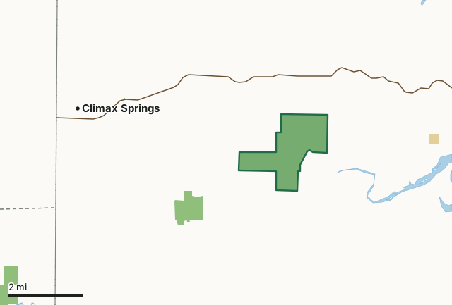
MDC conservation areasFederal land, mostly Corps of Engineers lakesFiery Fork Conservation AreaCounty lineLakeHighway
| Size | 1,584 acres |
|---|---|
| County | Camden County |
| Deer harvest unit | Camden County |
| MDC lists for hunting | Deer, Bear, Turkey, Rabbit and Squirrel |
| MDC area number | 8103 |
| MDC region | Central |
| Camping (MDC) | individual campsites |
| Nearest towns | Climax Springs (4 mi), Macks Creek (7 mi) and Friedenswald (9 mi) |
What is Fiery Fork Conservation Area like?
Fiery Fork Conservation Area is in Camden County, 15 miles northwest of Camdenton and seven miles east of Climax Springs, off Highway 7. The area includes 1,509 acres of oak and hickory forest and was named after Fiery Fork Creek, which flows into the Niangua River.
During your visit to Fiery Fork Conservation Area, you may view various forest improvement practices designed to improve wildlife habitat, maintain watershed quality, enhance tree growth, quality, and species composition. Signs of disturbance are only temporary and the forest will soon return to normal. Hiking trails on the area vary in length from 0.25 mile to 1.25 miles and offer ideal opportunities to view wildlife in its natural setting. All boundaries of the area are marked from tree to tree with blue paint and are posted where they intersect state and county roads or private lands. Visitors are urged to respect the rights of adjacent land owners.
In MDC's words, from the Fiery Fork Conservation Area page.
What can you hunt on Fiery Fork Conservation Area?
MDC's page for Fiery Fork Conservation Area lists: Deer: archery and firearms, archery antlerless permits only; Bear: archery and firearms; Turkey: archery and firearms; Rabbit; Squirrel.
What are the rules on Fiery Fork Conservation Area?
MDC's standard conservation area rules (Chapter 11 of the Wildlife Code) apply; the area's rules on MDC's site list any it adds.
How many deer are taken around Fiery Fork Conservation Area?
Fiery Fork Conservation Area lies in Camden County. Hunters checked 3,714 deer in Camden County in 2025, against 2,963 in 2024.
| County | Fiery Fork Conservation Area acres in it | Deer, 2025 | Deer, 2024 | Deer, 2023 |
|---|---|---|---|---|
| Camden County | 1,584 | 3,714 | 2,963 | 3,863 |
Harvest for the whole county, not the conservation area alone: MDC deer harvest summaries (2021 to 2025 seasons).
How do you get to Fiery Fork Conservation Area?
MDC's directions: From Climax Springs, take Highway 7 east 4.30 miles, then take Granger Lane south 2 miles. Watch for signs.
Nearest towns: Climax Springs (4 miles), Macks Creek (7 miles), Friedenswald (9 miles) and Sunrise Beach (9 miles). Highways within 5 miles: MO 7.
What other public land is near Fiery Fork Conservation Area?
MDC lands within 10 miles:
- Burnt Mill Cave Conservation Area: 317 acres, 1.2 miles away
- Larry R. Gale Access: 214 acres, 5.9 miles away
- Mule Shoe Conservation Area: 2,839 acres, 6.4 miles away
- Camdenton Conservation Service Center: 45 acres, 8.6 miles away
Public land within 3 miles of Fiery Fork Conservation Area
Counting Fiery Fork Conservation Area itself, 1,952 of the 34,236 acres within 3 miles of its boundary are public land open to the public (5.7%), by USGS PAD-US 4.1 and MDC conservation area boundaries.
| Manager | Acres within 3 miles |
|---|---|
| MDC conservation areas | 1,911 |
| Federal land, mostly Corps of Engineers lakes | 41 |
Questions hunters ask
Where is Fiery Fork Conservation Area?
In Camden County, 4 miles from Climax Springs.
Can you deer hunt on Fiery Fork Conservation Area?
Yes, by MDC's page: archery and firearms, archery antlerless permits only.
How much public land is around Fiery Fork Conservation Area?
1,952 acres within 3 miles of its boundary, Fiery Fork Conservation Area included, by USGS PAD-US 4.1 and MDC conservation area boundaries. The closest other MDC area is Burnt Mill Cave Conservation Area (1.2 miles).
Get a Missouri hunt plan when they open
Hunt plans for Missouri are coming. Join the list and you'll hear first. The first 50 hunters in each new state get their plan free.
Until then, the free FilledTag app for iPhone has a map that works in every state, Missouri included.
Where these facts come from
- Area description, species, rules and directions: MDC, Fiery Fork Conservation Area; MDC conservation area boundaries.
- Boundary and acres: MDC's map layer above. Surrounding public land: USGS PAD-US 4.1 (fee land open to the public) and MDC conservation area boundaries.
- Deer harvest: MDC deer harvest summaries (2021 to 2025 seasons).
FilledTag is not part of the Missouri Department of Conservation. Check MDC's rules and posted signs before you go.