Mule Shoe Conservation Area: hunting and access
Mule Shoe Conservation Area is 2,839 acres of MDC land in Hickory and Camden counties, 5 miles from Climax Springs. MDC lists deer hunting here (archery and firearms, antlerless permits allowed). Hunters checked 2,578 deer in Hickory County in 2025.
Data updated October 2026. Area facts: MDC's conservation area data, read 2026-10. Harvest: MDC deer harvest summaries, 2021 to 2025.
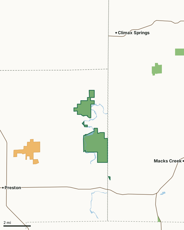
MDC conservation areasMRAP landMule Shoe Conservation AreaCounty lineLakeHighway
| Size | 2,839 acres in 4 pieces |
|---|---|
| Counties | Hickory County and Camden County |
| Deer harvest unit | Hickory County, Camden County |
| MDC lists for hunting | Deer, Bear, Turkey, Rabbit, Squirrel and Quail |
| MDC area number | 9111 |
| MDC region | Southwest |
| Camping (MDC) | designated camping sites |
| Nearest towns | Climax Springs (5 mi), Macks Creek (6 mi) and Cross Timbers (6 mi) |
What is Mule Shoe Conservation Area like?
Mule Shoe Conservation Area is located in eastern Hickory County. This 2,709-acre area borders the eastern bank of the Little Niangua River for over one mile. The area contains forestland, bottomland fields, and steep limestone bluffs. Natural communities include dry and dry-mesic chert forest, dolomite glades, a remnant dolomite savanna, and bottomland forests. Approximately 256 acres are pasture fields.
This area was acquired to provide upland wildlife habitat for public use and to help protect the aquatic habitat of the Little Niangua River. Hunting is allowed and there are opportunities for wildlife viewing. Camping is allowed only in spots designated on the area map. Campers are limited to 14 consecutive days in a 30-day period. There is a privy located at the designated camping area, but no other facilities are provided. Groups of more than 10 campers need a special use permit.
In MDC's words, from the Mule Shoe Conservation Area page.
What can you hunt on Mule Shoe Conservation Area?
MDC's page for Mule Shoe Conservation Area lists: Deer: archery and firearms, antlerless permits allowed; Bear: archery and firearms; Turkey: archery and firearms; Rabbit; Squirrel; Quail.
What are the rules on Mule Shoe Conservation Area?
MDC's standard conservation area rules (Chapter 11 of the Wildlife Code) apply; the area's rules on MDC's site list any it adds.
How many deer are taken around Mule Shoe Conservation Area?
Mule Shoe Conservation Area lies in 2 counties. Hunters checked 2,578 deer in Hickory County in 2025, against 2,456 in 2024.
| County | Mule Shoe Conservation Area acres in it | Deer, 2025 | Deer, 2024 | Deer, 2023 |
|---|---|---|---|---|
| Hickory County | 2,826 | 2,578 | 2,456 | 2,926 |
| Camden County | 13 | 3,714 | 2,963 | 3,863 |
Harvest for the whole county, not the conservation area alone: MDC deer harvest summaries (2021 to 2025 seasons).
How do you get to Mule Shoe Conservation Area?
MDC's directions: In Hickory County take Route F north from Highway 54, then gravel road 96 east to the area.
Nearest towns: Climax Springs (5 miles), Macks Creek (6 miles), Cross Timbers (6 miles) and Preston (6 miles). Highways within 5 miles: US 54, MO 7 and MO 73.
What other public land is near Mule Shoe Conservation Area?
MDC lands within 10 miles:
- Burnt Mill Cave Conservation Area: 317 acres, 4.4 miles away
- Fiery Fork Conservation Area: 1,584 acres, 6.4 miles away
- Lead Mine Conservation Area: 7,832 acres, 8.1 miles away
- Truman Reservoir Management Lands (Cross Timbers): 5,189 acres, 9.3 miles away
Public land within 3 miles of Mule Shoe Conservation Area
Counting Mule Shoe Conservation Area itself, 2,841 of the 51,854 acres within 3 miles of its boundary are public land open to the public (5.5%), by USGS PAD-US 4.1 and MDC conservation area boundaries.
| Manager | Acres within 3 miles |
|---|---|
| MDC conservation areas | 2,841 |
Questions hunters ask
Where is Mule Shoe Conservation Area?
In Hickory and Camden counties, 5 miles from Climax Springs.
Can you deer hunt on Mule Shoe Conservation Area?
Yes, by MDC's page: archery and firearms, antlerless permits allowed.
How much public land is around Mule Shoe Conservation Area?
2,841 acres within 3 miles of its boundary, Mule Shoe Conservation Area included, by USGS PAD-US 4.1 and MDC conservation area boundaries. The closest other MDC area is Burnt Mill Cave Conservation Area (4.4 miles).
Get a Missouri hunt plan when they open
Hunt plans for Missouri are coming. Join the list and you'll hear first. The first 50 hunters in each new state get their plan free.
Until then, the free FilledTag app for iPhone has a map that works in every state, Missouri included.
Where these facts come from
- Area description, species, rules and directions: MDC, Mule Shoe Conservation Area; MDC conservation area boundaries.
- Boundary and acres: MDC's map layer above. Surrounding public land: USGS PAD-US 4.1 (fee land open to the public) and MDC conservation area boundaries.
- Deer harvest: MDC deer harvest summaries (2021 to 2025 seasons).
FilledTag is not part of the Missouri Department of Conservation. Check MDC's rules and posted signs before you go.