Linscomb Wildlife Area: hunting and access
Linscomb Wildlife Area is 2,422 acres of MDC land in St. Clair County, 4 miles from Roscoe. MDC lists deer hunting here (archery and firearms, antlerless permits not allowed). Hunters checked 3,383 deer in St. Clair County in 2025.
Data updated October 2026. Area facts: MDC's conservation area data, read 2026-10. Harvest: MDC deer harvest summaries, 2021 to 2025.
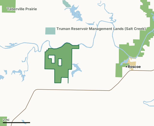
MDC conservation areasFederal land, mostly Corps of Engineers lakesNational wildlife refugesLinscomb Wildlife AreaCounty lineLakeHighway
| Size | 2,422 acres |
|---|---|
| County | St. Clair County |
| Deer harvest unit | St. Clair County |
| MDC lists for hunting | Deer, Bear, Turkey, Rabbit, Squirrel, Dove and Quail |
| MDC area number | 9904 |
| MDC region | Kansas City |
| Nearest towns | Roscoe (4 mi), El Dorado Springs (9 mi) and Rockville (10 mi) |
What is Linscomb Wildlife Area like?
Formerly known as Winding River Ranch, the property (1,728 acres) was deeded to the Missouri Department of Conservation from the NeVada P. Linscomb Trust in 1998. In 2003, Linscomb Trust purchased 146 additional acres. In 2023, the Missouri Department of Conservation purchased a 510-acre tract from Pheasants Forever/Quail Forever, with donations from the Dr. Harry and Lina Berrier Memorial Trust. The new Berrier Tract is now included and managed as one complex of diverse habitats that make up Linscomb WA.
This 2,384-acre wildlife area contains several small ponds. The Osage River Arm of Truman Reservoir borders to the north and Simms Creek borders to the east.The central portion of the area contains reconstructed prairie fields and small remnant prairie, along with oak/hickory savanna to the east. The southern portion is comprised of mixed grass fields. The remainder of the area consists of cropland, old fields, woodlands, glades, and wetlands.
In MDC's words, from the Linscomb Wildlife Area page.
What can you hunt on Linscomb Wildlife Area?
MDC's page for Linscomb Wildlife Area lists: Deer: archery and firearms, antlerless permits not allowed; Bear: archery and firearms; Turkey: archery and firearms; Rabbit; Squirrel; Dove; Quail.
What are the rules on Linscomb Wildlife Area?
MDC's standard conservation area rules (Chapter 11 of the Wildlife Code) apply; the area's rules on MDC's site list any it adds.
How many deer are taken around Linscomb Wildlife Area?
Linscomb Wildlife Area lies in St. Clair County. Hunters checked 3,383 deer in St. Clair County in 2025, against 3,309 in 2024.
| County | Linscomb Wildlife Area acres in it | Deer, 2025 | Deer, 2024 | Deer, 2023 |
|---|---|---|---|---|
| St. Clair County | 2,422 | 3,383 | 3,309 | 3,990 |
Harvest for the whole county, not the conservation area alone: MDC deer harvest summaries (2021 to 2025 seasons).
How do you get to Linscomb Wildlife Area?
MDC's directions: From El Dorado Springs, take Highway 82 northeast 9 miles, then Route OO north 1.50 miles.
Nearest towns: Roscoe (4 miles), El Dorado Springs (9 miles), Rockville (10 miles) and Schell City (10 miles). Highways within 5 miles: MO 82.
What other public land is near Linscomb Wildlife Area?
MDC lands within 10 miles:
- Truman Reservoir Management Lands (Salt Creek): 3,708 acres, 2.9 miles away
- Taberville Prairie Conservation Area: 1,693 acres, 3.5 miles away
- Wah'Kon-Tah Prairie: 3,563 acres, 4.3 miles away
- Schell-Osage Conservation Area: 8,654 acres, 4.7 miles away
- Lichen Glade Conservation Area: 34 acres, 6 miles away
- Truman Reservoir Management Lands (Sac-Osage): 6,267 acres, 6.2 miles away
Public land within 3 miles of Linscomb Wildlife Area
Counting Linscomb Wildlife Area itself, 2,800 of the 38,885 acres within 3 miles of its boundary are public land open to the public (7.2%), by USGS PAD-US 4.1 and MDC conservation area boundaries.
| Manager | Acres within 3 miles |
|---|---|
| MDC conservation areas | 2,460 |
| National wildlife refuges | 338 |
| Federal land, mostly Corps of Engineers lakes | 2 |
Questions hunters ask
Where is Linscomb Wildlife Area?
In St. Clair County, 4 miles from Roscoe.
Can you deer hunt on Linscomb Wildlife Area?
Yes, by MDC's page: archery and firearms, antlerless permits not allowed.
How much public land is around Linscomb Wildlife Area?
2,800 acres within 3 miles of its boundary, Linscomb Wildlife Area included, by USGS PAD-US 4.1 and MDC conservation area boundaries. The closest other MDC area is Truman Reservoir Management Lands (Salt Creek) (2.9 miles).
Get a Missouri hunt plan when they open
Hunt plans for Missouri are coming. Join the list and you'll hear first. The first 50 hunters in each new state get their plan free.
Until then, the free FilledTag app for iPhone has a map that works in every state, Missouri included.
Where these facts come from
- Area description, species, rules and directions: MDC, Linscomb Wildlife Area; MDC conservation area boundaries.
- Boundary and acres: MDC's map layer above. Surrounding public land: USGS PAD-US 4.1 (fee land open to the public) and MDC conservation area boundaries.
- Deer harvest: MDC deer harvest summaries (2021 to 2025 seasons).
FilledTag is not part of the Missouri Department of Conservation. Check MDC's rules and posted signs before you go.