Meramec Conservation Area: hunting and access
Meramec Conservation Area is 3,938 acres of MDC land in Franklin County, next to Miramiguoa Park. MDC lists deer hunting here (archery and firearms, antlerless permits allowed). Hunters checked 6,751 deer in Franklin County in 2025.
Data updated October 2026. Area facts: MDC's conservation area data, read 2026-10. Harvest: MDC deer harvest summaries, 2021 to 2025.
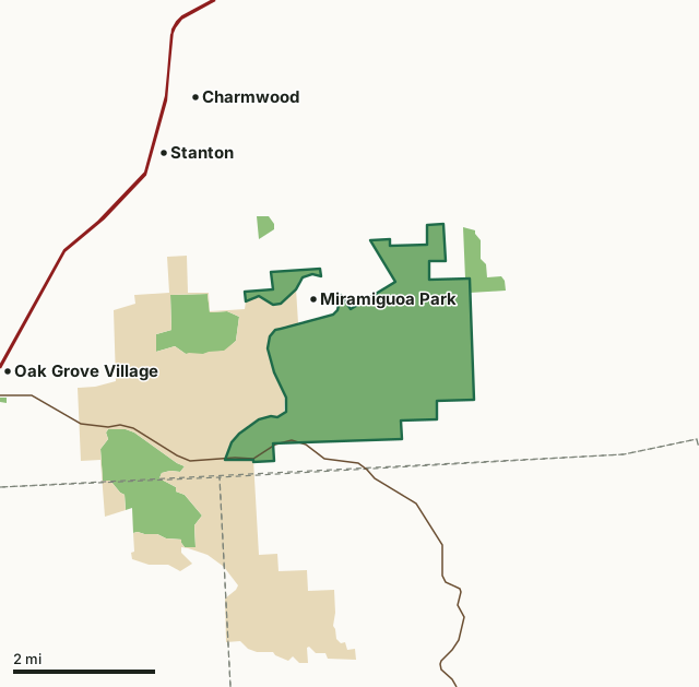
MDC conservation areasState parks and historic sitesMeramec Conservation AreaCounty lineHighway
| Size | 3,938 acres in 2 pieces |
|---|---|
| County | Franklin County |
| Deer harvest unit | Franklin County |
| MDC lists for hunting | Deer, Bear, Turkey and Squirrel |
| MDC area number | 6202 |
| MDC region | St. Louis |
| Nearest towns | Miramiguoa Park (next to it), Stanton (2 mi) and Charmwood (3 mi) |
What is Meramec Conservation Area like?
Meramec Conservation Area has something for almost any visitor, from those looking for a casual walk or a more challenging hike. The area's paved, one-mile loop trail provides a flat surface suitable for those with any level of mobility. It's not without its scenic charms. You'll pass by Black Onyx cave, lush forestland, and several tantalizing views of the Meramec River. Those seeking a more adventurous trek can depart from the paved trail and explore the extensive natural surface paths that meander through steep woods. Equestrians are welcome too, as much of the area's trail system is open to horseback riding, and the area offers a parking lot large enough to accommodate horse trailers.
In MDC's words, from the Meramec Conservation Area page.
What can you hunt on Meramec Conservation Area?
MDC's page for Meramec Conservation Area lists: Deer: archery and firearms, antlerless permits allowed; Bear: archery and firearms; Turkey: archery and firearms; Squirrel.
What are the rules on Meramec Conservation Area?
MDC's standard conservation area rules (Chapter 11 of the Wildlife Code) apply; the area's rules on MDC's site list any it adds.
How many deer are taken around Meramec Conservation Area?
Meramec Conservation Area lies in Franklin County. Hunters checked 6,751 deer in Franklin County in 2025, against 6,199 in 2024.
| County | Meramec Conservation Area acres in it | Deer, 2025 | Deer, 2024 | Deer, 2023 |
|---|---|---|---|---|
| Franklin County | 3,938 | 6,751 | 6,199 | 7,397 |
Harvest for the whole county, not the conservation area alone: MDC deer harvest summaries (2021 to 2025 seasons).
How do you get to Meramec Conservation Area?
MDC's directions: From I-44 near Sullivan, take Highway 185 south 5 miles to the area sign.
Nearest towns: Miramiguoa Park (next to it), Stanton (2 miles), Charmwood (3 miles) and Oak Grove Village (3 miles). Highways within 5 miles: I-44 and MO 185.
What other public land is near Meramec Conservation Area?
MDC lands within 10 miles:
- Sand Ford Access: 35 acres, 0.5 miles away
- Little Indian Creek Conservation Area: 4,153 acres, 3.4 miles away
- Long Ridge Conservation Area: 1,867 acres, 4.8 miles away
- Redhorse Access: 46 acres, 5.5 miles away
- Onyx Cave Conservation Area: 37 acres, 6.8 miles away
- Blue Springs Creek Conservation Area: 882 acres, 6.9 miles away
Public land within 3 miles of Meramec Conservation Area
Counting Meramec Conservation Area itself, 10,688 of the 45,948 acres within 3 miles of its boundary are public land open to the public (23.3%), by USGS PAD-US 4.1 and MDC conservation area boundaries.
| Manager | Acres within 3 miles |
|---|---|
| MDC conservation areas | 5,407 |
| State parks and historic sites | 5,281 |
Questions hunters ask
Where is Meramec Conservation Area?
In Franklin County, next to Miramiguoa Park.
Can you deer hunt on Meramec Conservation Area?
Yes, by MDC's page: archery and firearms, antlerless permits allowed.
How much public land is around Meramec Conservation Area?
10,688 acres within 3 miles of its boundary, Meramec Conservation Area included, by USGS PAD-US 4.1 and MDC conservation area boundaries. The closest other MDC area is Sand Ford Access (0.5 miles).
Get a Missouri hunt plan when they open
Hunt plans for Missouri are coming. Join the list and you'll hear first. The first 50 hunters in each new state get their plan free.
Until then, the free FilledTag app for iPhone has a map that works in every state, Missouri included.
Where these facts come from
- Area description, species, rules and directions: MDC, Meramec Conservation Area; MDC conservation area boundaries.
- Boundary and acres: MDC's map layer above. Surrounding public land: USGS PAD-US 4.1 (fee land open to the public) and MDC conservation area boundaries.
- Deer harvest: MDC deer harvest summaries (2021 to 2025 seasons).
FilledTag is not part of the Missouri Department of Conservation. Check MDC's rules and posted signs before you go.