Blue Springs Creek Conservation Area: hunting and access
Blue Springs Creek Conservation Area is 882 acres of MDC land in Crawford County, 3 miles from Bourbon. MDC lists deer hunting here (muzzleloader and archery, antlerless permits allowed). Hunters checked 3,667 deer in Crawford County in 2025.
Data updated October 2026. Area facts: MDC's conservation area data, read 2026-10. Harvest: MDC deer harvest summaries, 2021 to 2025.
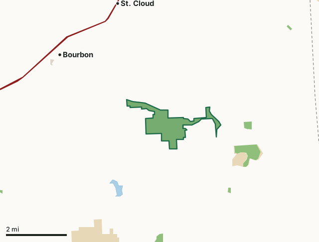
MDC conservation areasState parks and historic sitesCounty, city and regional landBlue Springs Creek Conservation AreaCounty lineLakeHighway
| Size | 882 acres |
|---|---|
| County | Crawford County |
| Deer harvest unit | Crawford County |
| MDC lists for hunting | Deer, Bear, Turkey, Rabbit and Squirrel |
| MDC area number | 8405 |
| MDC region | St. Louis |
| Nearest towns | Bourbon (3 mi), St. Cloud (3 mi) and West Sullivan (5 mi) |
What is Blue Springs Creek Conservation Area like?
This area was acquired from the U.S. Army Corps of Engineers in 1983. An additional tract was added in 1992, increasing the size of the area to 859 acres.
The area was named after Blue Springs Creek, which flows for four miles through the area to its confluence with the Meramec River. Blue Springs Creek is fed by four springs that arise on nearby private property. The springs provide a flow of between four and seven million gallons of water per day. Blue Springs Creek is managed for rainbow trout and the adjoining property supports a wide variety of game and non-game species. Deer, turkey, and squirrels are abundant. The area's diverse vegetation includes lowland timber species, such as sycamore, willow and river birch, and upland hardwoods, including black oak, white oak, post oak and hickory.
In MDC's words, from the Blue Springs Creek Conservation Area page.
What can you hunt on Blue Springs Creek Conservation Area?
MDC's page for Blue Springs Creek Conservation Area lists: Deer: muzzleloader and archery, antlerless permits allowed; Bear: archery and firearms; Turkey: archery and firearms; Rabbit; Squirrel.
What are the rules on Blue Springs Creek Conservation Area?
MDC's standard conservation area rules (Chapter 11 of the Wildlife Code) apply; the area's rules on MDC's site list any it adds.
How many deer are taken around Blue Springs Creek Conservation Area?
Blue Springs Creek Conservation Area lies in Crawford County. Hunters checked 3,667 deer in Crawford County in 2025, against 3,082 in 2024.
| County | Blue Springs Creek Conservation Area acres in it | Deer, 2025 | Deer, 2024 | Deer, 2023 |
|---|---|---|---|---|
| Crawford County | 882 | 3,667 | 3,082 | 4,406 |
Harvest for the whole county, not the conservation area alone: MDC deer harvest summaries (2021 to 2025 seasons).
How do you get to Blue Springs Creek Conservation Area?
MDC's directions: From Bourbon, take Route N south 2.50 miles to Blue Springs Road. There is parking available off of Route N as well as Blue Springs Road.
Nearest towns: Bourbon (3 miles), St. Cloud (3 miles), West Sullivan (5 miles) and Leasburg (5 miles). Highways within 5 miles: I-44.
What other public land is near Blue Springs Creek Conservation Area?
MDC lands within 10 miles:
- Onyx Cave Conservation Area: 37 acres, 0.8 miles away
- Huzzah Conservation Area: 6,079 acres, 2.8 miles away
- Pea Ridge Conservation Area: 8,757 acres, 6.7 miles away
- Meramec Conservation Area: 3,938 acres, 6.9 miles away
- Sand Ford Access: 35 acres, 9.9 miles away
Public land within 3 miles of Blue Springs Creek Conservation Area
Counting Blue Springs Creek Conservation Area itself, 1,303 of the 34,695 acres within 3 miles of its boundary are public land open to the public (3.8%), by USGS PAD-US 4.1 and MDC conservation area boundaries.
| Manager | Acres within 3 miles |
|---|---|
| MDC conservation areas | 1,163 |
| State parks and historic sites | 131 |
| County, city and regional land | 9 |
Questions hunters ask
Where is Blue Springs Creek Conservation Area?
In Crawford County, 3 miles from Bourbon.
Can you deer hunt on Blue Springs Creek Conservation Area?
Yes, by MDC's page: muzzleloader and archery, antlerless permits allowed.
How much public land is around Blue Springs Creek Conservation Area?
1,303 acres within 3 miles of its boundary, Blue Springs Creek Conservation Area included, by USGS PAD-US 4.1 and MDC conservation area boundaries. The closest other MDC area is Onyx Cave Conservation Area (0.8 miles).
Get a Missouri hunt plan when they open
Hunt plans for Missouri are coming. Join the list and you'll hear first. The first 50 hunters in each new state get their plan free.
Until then, the free FilledTag app for iPhone has a map that works in every state, Missouri included.
Where these facts come from
- Area description, species, rules and directions: MDC, Blue Springs Creek Conservation Area; MDC conservation area boundaries.
- Boundary and acres: MDC's map layer above. Surrounding public land: USGS PAD-US 4.1 (fee land open to the public) and MDC conservation area boundaries.
- Deer harvest: MDC deer harvest summaries (2021 to 2025 seasons).
FilledTag is not part of the Missouri Department of Conservation. Check MDC's rules and posted signs before you go.