Pea Ridge Conservation Area: hunting and access
Pea Ridge Conservation Area is 8,757 acres of MDC land in Washington County, 6 miles from Potosi. MDC lists deer hunting here (archery and firearms, antlerless permits allowed). Hunters checked 3,425 deer in Washington County in 2025.
Data updated October 2026. Area facts: MDC's conservation area data, read 2026-10. Harvest: MDC deer harvest summaries, 2021 to 2025.
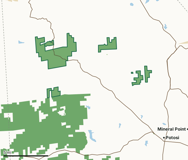
MDC conservation areasNational forestState parks and historic sitesPea Ridge Conservation AreaCounty lineLakeHighway
| Size | 8,757 acres in 8 pieces |
|---|---|
| County | Washington County |
| Deer harvest unit | Washington County |
| MDC lists for hunting | Deer, Bear, Turkey, Rabbit, Squirrel, Dove and Quail |
| MDC area number | 4711 |
| MDC region | St. Louis |
| Camping (MDC) | individual campsites |
| Nearest towns | Potosi (6 mi), Mineral Point (7 mi) and Miramiguoa Park (9 mi) |
What is Pea Ridge Conservation Area like?
Pea Ridge Conservation Area is in Washington County. The area consists of four tracts of land, the largest of which straddles Highway 185, midway between Sullivan and Potosi. The 1,058-acre Hi Pointe tract is bisected by Pelican Ridge Road off of Route T. The 1,045-acre Route F Unit is accessed from Route F and Sugar Loaf Road, and the 720-acre Metcalf School Unit is accessed from Lodge Road off of Route W.
The Conservation Department began purchasing land for the Pea Ridge Conservation Area in 1946 with the bulk of the main tract acquired in the 1970s. Pittman-Robertson funds allowed the purchase of 265 acres in 1978. At one time, the Jefferson City Trail ran through the main tract. The Rock Springs General Store and Post Office were once located on the trail. The forest is composed of oak, hickory, pine, and associated species. Cedar is found in glade areas, and bottomland hardwoods are found along streams. The main tract includes a fen,four springs, a sinkhole, a dolomite cliff, 10 dolomite glades, and over three miles of Indian Creek, an Ozark headwater stream. Moisture loving plants, such as hydrangea, common fragile fern, pawpaw, basswood, and wild ginger, grow at the base of the dolomite cliff. Drought-tolerant plants, such as little bluestem, side oats grama grass, Missouri...
In MDC's words, from the Pea Ridge Conservation Area page.
What can you hunt on Pea Ridge Conservation Area?
MDC's page for Pea Ridge Conservation Area lists: Deer: archery and firearms, antlerless permits allowed; Bear: archery and firearms; Turkey: archery and firearms; Rabbit; Squirrel; Dove; Quail.
What are the rules on Pea Ridge Conservation Area?
MDC's standard conservation area rules (Chapter 11 of the Wildlife Code) apply; the area's rules on MDC's site list any it adds.
How many deer are taken around Pea Ridge Conservation Area?
Pea Ridge Conservation Area lies in Washington County. Hunters checked 3,425 deer in Washington County in 2025, against 2,485 in 2024.
| County | Pea Ridge Conservation Area acres in it | Deer, 2025 | Deer, 2024 | Deer, 2023 |
|---|---|---|---|---|
| Washington County | 8,757 | 3,425 | 2,485 | 4,106 |
Harvest for the whole county, not the conservation area alone: MDC deer harvest summaries (2021 to 2025 seasons).
How do you get to Pea Ridge Conservation Area?
MDC's directions: Pea Ridge Conservation Area is in Washington County. The area consists of four tracts of land, the largest of which straddles Highway 185, midway between Sullivan and Potosi. The 1,058-acre Hi Pointe tract is bisected by Pelican Ridge Road off of Route T. The 1,045-acre Route F Unit is accessed from Route F and Sugar Loaf Road, and the 720-acre Metcalf School Unit is accessed from Lodge Road off of Route W.
Nearest towns: Potosi (6 miles), Mineral Point (7 miles), Miramiguoa Park (9 miles) and Sullivan (10 miles). Highways within 5 miles: MO 185, MO 47 and MO 21.
What other public land is near Pea Ridge Conservation Area?
MDC lands within 10 miles:
- Little Indian Creek Conservation Area: 4,153 acres, 5.4 miles away
- Kingston Access: 56 acres, 5.5 miles away
- Onyx Cave Conservation Area: 37 acres, 5.7 miles away
- Blue Springs Creek Conservation Area: 882 acres, 6.7 miles away
- Huzzah Conservation Area: 6,079 acres, 7 miles away
- Meramec Conservation Area: 3,938 acres, 7.2 miles away
Public land within 3 miles of Pea Ridge Conservation Area
Counting Pea Ridge Conservation Area itself, 18,188 of the 116,523 acres within 3 miles of its boundary are public land open to the public (15.6%), by USGS PAD-US 4.1 and MDC conservation area boundaries.
| Manager | Acres within 3 miles |
|---|---|
| National forest | 9,417 |
| MDC conservation areas | 8,771 |
Questions hunters ask
Where is Pea Ridge Conservation Area?
In Washington County, 6 miles from Potosi.
Can you deer hunt on Pea Ridge Conservation Area?
Yes, by MDC's page: archery and firearms, antlerless permits allowed.
How much public land is around Pea Ridge Conservation Area?
18,188 acres within 3 miles of its boundary, Pea Ridge Conservation Area included, by USGS PAD-US 4.1 and MDC conservation area boundaries. The closest other MDC area is Little Indian Creek Conservation Area (5.4 miles).
Get a Missouri hunt plan when they open
Hunt plans for Missouri are coming. Join the list and you'll hear first. The first 50 hunters in each new state get their plan free.
Until then, the free FilledTag app for iPhone has a map that works in every state, Missouri included.
Where these facts come from
- Area description, species, rules and directions: MDC, Pea Ridge Conservation Area; MDC conservation area boundaries.
- Boundary and acres: MDC's map layer above. Surrounding public land: USGS PAD-US 4.1 (fee land open to the public) and MDC conservation area boundaries.
- Deer harvest: MDC deer harvest summaries (2021 to 2025 seasons).
FilledTag is not part of the Missouri Department of Conservation. Check MDC's rules and posted signs before you go.