Monegaw Prairie Conservation Area: hunting and access
Monegaw Prairie Conservation Area is 267 acres of MDC land in Cedar County, 3 miles from El Dorado Springs. MDC lists deer hunting here (archery only, antlerless permits allowed). Hunters checked 2,334 deer in Cedar County in 2025.
Data updated October 2026. Area facts: MDC's conservation area data, read 2026-10. Harvest: MDC deer harvest summaries, 2021 to 2025.
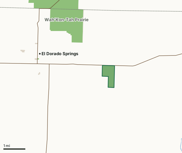
MDC conservation areasCounty, city and regional landLand trusts and other open landMonegaw Prairie Conservation AreaCounty lineLakeHighway
| Size | 267 acres |
|---|---|
| County | Cedar County |
| Deer harvest unit | Cedar County |
| MDC lists for hunting | Deer, Turkey, Rabbit and Quail |
| MDC area number | 7817 |
| MDC region | Southwest |
| Nearest towns | El Dorado Springs (3 mi), Roscoe (11 mi) and Harwood (12 mi) |
What is Monegaw Prairie Conservation Area like?
Monegaw Prairie is a remnant of the tallgrass prairie ecosystem that once covered more than one-quarter of Missouri. It is also home to plants and animals that are specially adapted for life on the open prairie.
Less than one-half of one percent of original prairie remains in Missouri making some of these species increasingly rare. Managers use prescribed burning, haying, and other tools to simulate historic disturbances that maintain healthy grasslands and limit the negative impacts of invasive plants - including trees - which were historically uncommon here. Management priorities include providing nesting and brood-rearing habitat for bobwhite quail and other grassland birds such as Henslow's sparrow and upland sandpiper. Monitoring and management for a number of lesser known species is also important; some which find a home here include: Mead's milkweed, prairie mole crickets, northern crawfish frog, slender glass lizard, grasshopper sparrow, Loggerhead shrike, and Northern harrier.
In MDC's words, from the Monegaw Prairie Conservation Area page.
What can you hunt on Monegaw Prairie Conservation Area?
MDC's page for Monegaw Prairie Conservation Area lists: Deer: archery only, antlerless permits allowed; Turkey: archery and firearms; Rabbit; Quail.
What are the rules on Monegaw Prairie Conservation Area?
MDC's standard conservation area rules (Chapter 11 of the Wildlife Code) apply; the area's rules on MDC's site list any it adds.
How many deer are taken around Monegaw Prairie Conservation Area?
Monegaw Prairie Conservation Area lies in Cedar County. Hunters checked 2,334 deer in Cedar County in 2025, against 2,191 in 2024.
| County | Monegaw Prairie Conservation Area acres in it | Deer, 2025 | Deer, 2024 | Deer, 2023 |
|---|---|---|---|---|
| Cedar County | 267 | 2,334 | 2,191 | 2,658 |
Harvest for the whole county, not the conservation area alone: MDC deer harvest summaries (2021 to 2025 seasons).
How do you get to Monegaw Prairie Conservation Area?
MDC's directions: From El Dorado Springs, take Highway 54 east 2.5 miles.
Nearest towns: El Dorado Springs (3 miles), Roscoe (11 miles), Harwood (12 miles) and Stockton (14 miles). Highways within 5 miles: US 54, MO 82, MO 32 and MO 39.
What other public land is near Monegaw Prairie Conservation Area?
MDC lands within 10 miles:
- Wah'Kon-Tah Prairie: 3,563 acres, 1.4 miles away
- Linscomb Wildlife Area: 2,422 acres, 7.4 miles away
- Schell-Osage Conservation Area: 8,654 acres, 8.3 miles away
- Truman Reservoir Management Lands (Salt Creek): 3,708 acres, 10 miles away
Public land within 3 miles of Monegaw Prairie Conservation Area
Counting Monegaw Prairie Conservation Area itself, 1,308 of the 23,969 acres within 3 miles of its boundary are public land open to the public (5.5%), by USGS PAD-US 4.1 and MDC conservation area boundaries.
| Manager | Acres within 3 miles |
|---|---|
| MDC conservation areas | 1,282 |
| Land trusts and other open land | 20 |
| County, city and regional land | 6 |
Questions hunters ask
Where is Monegaw Prairie Conservation Area?
In Cedar County, 3 miles from El Dorado Springs.
Can you deer hunt on Monegaw Prairie Conservation Area?
Yes, by MDC's page: archery only, antlerless permits allowed.
How much public land is around Monegaw Prairie Conservation Area?
1,308 acres within 3 miles of its boundary, Monegaw Prairie Conservation Area included, by USGS PAD-US 4.1 and MDC conservation area boundaries. The closest other MDC area is Wah'Kon-Tah Prairie (1.4 miles).
Get a Missouri hunt plan when they open
Hunt plans for Missouri are coming. Join the list and you'll hear first. The first 50 hunters in each new state get their plan free.
Until then, the free FilledTag app for iPhone has a map that works in every state, Missouri included.
Where these facts come from
- Area description, species, rules and directions: MDC, Monegaw Prairie Conservation Area; MDC conservation area boundaries.
- Boundary and acres: MDC's map layer above. Surrounding public land: USGS PAD-US 4.1 (fee land open to the public) and MDC conservation area boundaries.
- Deer harvest: MDC deer harvest summaries (2021 to 2025 seasons).
FilledTag is not part of the Missouri Department of Conservation. Check MDC's rules and posted signs before you go.