Monkey Mountain Conservation Area: hunting and access
Monkey Mountain Conservation Area is 1,598 acres of MDC land in Holt and Andrew counties, 5 miles from Amazonia. MDC lists deer hunting here (archery and firearms, antlerless permits not allowed). Hunters checked 849 deer in Holt County in 2025.
Data updated October 2026. Area facts: MDC's conservation area data, read 2026-10. Harvest: MDC deer harvest summaries, 2021 to 2025.
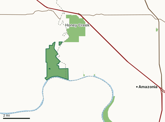
MDC conservation areasMonkey Mountain Conservation AreaCounty lineLakeHighway
| Size | 1,598 acres in 2 pieces |
|---|---|
| Counties | Holt County and Andrew County |
| Deer harvest unit | Holt County, Andrew County |
| MDC lists for hunting | Deer, Turkey, Rabbit, Squirrel and Dove |
| MDC area number | 7805 |
| MDC region | Northwest |
| Camping (MDC) | individual campsites and boat-in along missouri river |
| Nearest towns | Amazonia (5 mi), Fillmore (6 mi) and Oregon (7 mi) |
What is Monkey Mountain Conservation Area like?
Monkey Mountain Conservation Area is in Holt County, northwest of St. Joseph. The Conservation Department purchased this area in 1978 to provide public land for outdoor activities in northwest Missouri. The United States Army Corps of Engineers has purchased an additional 560 acres adjoining MDC's area, as part of the Missouri River Mitigation Project. The mitigation project has been designed to enhance fish and wildlife habitat along the Missouri River. The area is managed through a cooperative effort between the Corps of Engineers and the Missouri Department of Conservation.
This area was called "Monkey Mountains," because early settlers deemed the river bluffs too steep for even monkeys to climb. The Lewis and Clark Expedition opened up this portion of the state for settlement, when it passed along the southern portion of the area on July 8, 1804. Settlement began on a large scale in 1836. At that time about 20 percent of the county, primarily the steep slopes, was in upland forest cover, consisting mainly of bur oak, white oak, red oak, black walnut, American elm, hickory and basswood. The remainder of the land, mostly ridge tops and rounded knolls, was either grassland or open timber with an understory of native grass. Monkey Mountain Conservation Area is managed for a wide range of game and non-game wildlife species. The area is available to the public for a variety of outdoor activities. Management of the area includes farming, haying and prescribed...
In MDC's words, from the Monkey Mountain Conservation Area page.
What can you hunt on Monkey Mountain Conservation Area?
MDC's page for Monkey Mountain Conservation Area lists: Deer: archery and firearms, antlerless permits not allowed; Turkey: archery and firearms; Rabbit; Squirrel; Dove.
What are the rules on Monkey Mountain Conservation Area?
MDC's standard conservation area rules (Chapter 11 of the Wildlife Code) apply; the area's rules on MDC's site list any it adds.
How many deer are taken around Monkey Mountain Conservation Area?
Monkey Mountain Conservation Area lies in 2 counties. Hunters checked 849 deer in Holt County in 2025, against 846 in 2024.
| County | Monkey Mountain Conservation Area acres in it | Deer, 2025 | Deer, 2024 | Deer, 2023 |
|---|---|---|---|---|
| Holt County | 1,505 | 849 | 846 | 835 |
| Andrew County | 93 | 1,065 | 1,039 | 1,115 |
Harvest for the whole county, not the conservation area alone: MDC deer harvest summaries (2021 to 2025 seasons).
How do you get to Monkey Mountain Conservation Area?
MDC's directions: From I-29 Exit 67 north of St. Joseph, take Highway 59 west 4 miles, then Route U south 3.50 miles to the area sign, and County Road 325 east for about 1 mile.
Nearest towns: Amazonia (5 miles), Fillmore (6 miles), Oregon (7 miles) and Savannah (9 miles). Highways within 5 miles: I-29 and US 59.
What other public land is near Monkey Mountain Conservation Area?
MDC lands within 10 miles:
- Honey Creek Conservation Area: 1,458 acres, next to it
- Worthwine Island Conservation Area: 635 acres, 3.5 miles away
- Riverbreaks Conservation Area: 2,275 acres, 3.5 miles away
- Wolf Creek Bend Conservation Area: 983 acres, 7.4 miles away
Public land within 3 miles of Monkey Mountain Conservation Area
Counting Monkey Mountain Conservation Area itself, 3,074 of the 36,521 acres within 3 miles of its boundary are public land open to the public (8.4%), by USGS PAD-US 4.1 and MDC conservation area boundaries.
| Manager | Acres within 3 miles |
|---|---|
| MDC conservation areas | 3,074 |
Questions hunters ask
Where is Monkey Mountain Conservation Area?
In Holt and Andrew counties, 5 miles from Amazonia.
Can you deer hunt on Monkey Mountain Conservation Area?
Yes, by MDC's page: archery and firearms, antlerless permits not allowed.
How much public land is around Monkey Mountain Conservation Area?
3,074 acres within 3 miles of its boundary, Monkey Mountain Conservation Area included, by USGS PAD-US 4.1 and MDC conservation area boundaries. The closest other MDC area is Honey Creek Conservation Area (next to it).
Get a Missouri hunt plan when they open
Hunt plans for Missouri are coming. Join the list and you'll hear first. The first 50 hunters in each new state get their plan free.
Until then, the free FilledTag app for iPhone has a map that works in every state, Missouri included.
Where these facts come from
- Area description, species, rules and directions: MDC, Monkey Mountain Conservation Area; MDC conservation area boundaries.
- Boundary and acres: MDC's map layer above. Surrounding public land: USGS PAD-US 4.1 (fee land open to the public) and MDC conservation area boundaries.
- Deer harvest: MDC deer harvest summaries (2021 to 2025 seasons).
FilledTag is not part of the Missouri Department of Conservation. Check MDC's rules and posted signs before you go.