Riverbreaks Conservation Area: hunting and access
Riverbreaks Conservation Area is 2,275 acres of MDC land in Holt County, 2 miles from Oregon. MDC lists deer hunting here (archery and firearms, antlerless permits not allowed). Hunters checked 849 deer in Holt County in 2025.
Data updated October 2026. Area facts: MDC's conservation area data, read 2026-10. Harvest: MDC deer harvest summaries, 2021 to 2025.
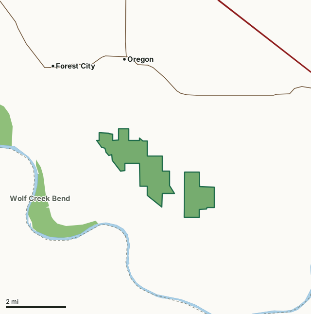
MDC conservation areasRiverbreaks Conservation AreaCounty lineLakeHighway
| Size | 2,275 acres in 2 pieces |
|---|---|
| County | Holt County |
| Deer harvest unit | Holt County |
| MDC lists for hunting | Deer, Turkey, Rabbit, Squirrel and Quail |
| MDC area number | 8114 |
| MDC region | Northwest |
| Camping (MDC) | designated camping sites and individual campsites |
| Shooting range (MDC) | rifle or pistol |
| Nearest towns | Oregon (2 mi), Forest City (3 mi) and Fillmore (9 mi) |
What is Riverbreaks Conservation Area like?
Riverbreaks Conservation Area is located in southern portion of Holt County. The area is in two adjacent tracts approximately four miles southeast of the town of Oregon, off of Route O and Route T. This 2,307-acre area is nestled among the loess hill river bluffs overlooking the Missouri River floodplain. Prior to settlement, Riverbreaks was likely covered by a mix of forest and grasslands. Settlers cleared, cropped or allowed animals to graze portions of the land. The area is continuing to change and currently is a diverse combination of forest, grasslands (both new and old), and cropfields. Native loess hill prairie remnants still exists in small pockets. The forest consists primarily of upland oak hickory mixed hardwoods with scattered pockets of bottomland hardwoods. Three permanent named creeks wind through the area. In addition there are three small fishable ponds which have been stocked with bluegill, largemouth bass, and channel catfish. Several other small fishless wildlife water holes are scattered throughout the area. The soils in the area consists of very deep (in some locations as deep as 280 feet) wind-blown silt, called loess, covering a limestone base. Several abandoned limestone quarries can be found along the south side of the area. Riverbreaks Conservation Area is managed for a variety of uses, including outdoor recreation and education, wildlife habitat, productive sustainable forests and soil and water protection. Area management practices include wildlife watering holes, planted wildlife food sources, establishing and managing (often with controlled fire) native warm season grasslands,and harvesting timber for wildlife habitat and sustainable forests. An unstaffed single projectile target shooting range is located in the center of the west tract off of Quebec Road (gravel).
In MDC's words, from the Riverbreaks Conservation Area page.
What can you hunt on Riverbreaks Conservation Area?
MDC's page for Riverbreaks Conservation Area lists: Deer: archery and firearms, antlerless permits not allowed; Turkey: archery and firearms; Rabbit; Squirrel; Quail.
What are the rules on Riverbreaks Conservation Area?
Target Shooting and Shooting Ranges: An unstaffed range is located on this department area. Target shooting is not allowed anywhere on this area except for designated shooting range(s). Shooting hours are one-half hour before sunrise to one-half hour after sunset. Ranges may be closed to public use at any time for maintenance or department sponsored events or programs. Possession of alcoholic beverages is prohibited on all ranges and associated parking lots. Groups of more than 10 people must obtain a special use permit prior to using the range. To obtain a special use permit, contact the area manager at the phone number listed...
Every conservation area also follows MDC's standard rules in Chapter 11 of the Wildlife Code; the area's full rules are on MDC's site.
How many deer are taken around Riverbreaks Conservation Area?
Riverbreaks Conservation Area lies in Holt County. Hunters checked 849 deer in Holt County in 2025, against 846 in 2024.
| County | Riverbreaks Conservation Area acres in it | Deer, 2025 | Deer, 2024 | Deer, 2023 |
|---|---|---|---|---|
| Holt County | 2,275 | 849 | 846 | 835 |
Harvest for the whole county, not the conservation area alone: MDC deer harvest summaries (2021 to 2025 seasons).
How do you get to Riverbreaks Conservation Area?
MDC's directions: Area consists of two tracts.
Nearest towns: Oregon (2 miles), Forest City (3 miles), Fillmore (9 miles) and Amazonia (10 miles). Highways within 5 miles: US 59, MO 111 and I-29.
What other public land is near Riverbreaks Conservation Area?
MDC lands within 10 miles:
- Wolf Creek Bend Conservation Area: 983 acres, 1.9 miles away
- Bob Brown Conservation Area: 3,362 acres, 2.8 miles away
- Monkey Mountain Conservation Area: 1,598 acres, 3.5 miles away
- Honey Creek Conservation Area: 1,458 acres, 4.9 miles away
- Jamerson C. McCormack Conservation Area: 223 acres, 7.6 miles away
Public land within 3 miles of Riverbreaks Conservation Area
Counting Riverbreaks Conservation Area itself, 3,065 of the 41,596 acres within 3 miles of its boundary are public land open to the public (7.4%), by USGS PAD-US 4.1 and MDC conservation area boundaries.
| Manager | Acres within 3 miles |
|---|---|
| MDC conservation areas | 3,065 |
Questions hunters ask
Where is Riverbreaks Conservation Area?
In Holt County, 2 miles from Oregon.
Can you deer hunt on Riverbreaks Conservation Area?
Yes, by MDC's page: archery and firearms, antlerless permits not allowed.
How much public land is around Riverbreaks Conservation Area?
3,065 acres within 3 miles of its boundary, Riverbreaks Conservation Area included, by USGS PAD-US 4.1 and MDC conservation area boundaries. The closest other MDC area is Wolf Creek Bend Conservation Area (1.9 miles).
Get a Missouri hunt plan when they open
Hunt plans for Missouri are coming. Join the list and you'll hear first. The first 50 hunters in each new state get their plan free.
Until then, the free FilledTag app for iPhone has a map that works in every state, Missouri included.
Where these facts come from
- Area description, species, rules and directions: MDC, Riverbreaks Conservation Area; MDC conservation area boundaries.
- Boundary and acres: MDC's map layer above. Surrounding public land: USGS PAD-US 4.1 (fee land open to the public) and MDC conservation area boundaries.
- Deer harvest: MDC deer harvest summaries (2021 to 2025 seasons).
FilledTag is not part of the Missouri Department of Conservation. Check MDC's rules and posted signs before you go.