Bob Brown Conservation Area: hunting and access
Bob Brown Conservation Area is 3,362 acres of MDC land in Holt County, 2 miles from Forest City. MDC lists deer hunting here (archery only, antlerless permits allowed). Hunters checked 849 deer in Holt County in 2025.
Data updated October 2026. Area facts: MDC's conservation area data, read 2026-10. Harvest: MDC deer harvest summaries, 2021 to 2025.
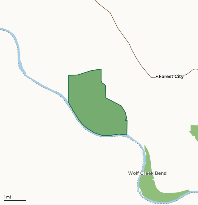
MDC conservation areasBob Brown Conservation AreaCounty lineLakeHighway
| Size | 3,362 acres |
|---|---|
| County | Holt County |
| Deer harvest unit | Holt County |
| MDC lists for hunting | Deer, Turkey, Rabbit, Dove and Quail |
| MDC area number | 8142 |
| MDC region | Northwest |
| Camping (MDC) | designated camping sites |
| Nearest towns | Forest City (2 mi), Oregon (4 mi) and Fortescue (5 mi) |
What is Bob Brown Conservation Area like?
This area which was named for the late Robert A. Brown, a St. Joseph conservationist, consists of 3,307 acres of bottomland and is bounded by the Missouri River for three miles. The rich bottomland soils support mixed lowland hardwood forest, and also are planted with cool- and warm-season grasses and agricultural crops. A major portion of the land is restored Missouri River wetlands, which provide habitat for migrating waterfowl as well as resident species. The area is primarily managed to provide wetland habitat. The area's proximity to Loess Bluff National Wildlife Refuge (five miles) provides excellent opportunities to observe bald eagles, shorebirds, and migratory waterfowl. Wildlife viewing is encouraged. Public use is allowed throughout the year, but non-hunters are prohibited from the waterfowl hunting zone during waterfowl hunting season, unless they are members of a hunting party authorized to use the area and remain with the group. This area has been designated by Audubon Missouri as an Important Bird Area (IBA). IBAs are sites that have been identified by Audubon as those that are the most crucial for bird population, due to their abundance and/or diversity of birds present. Peak times for viewing waterfowl occurs in mid-November and mid-March. Pedestrians will find good wildlife viewing from the area's roads. Mid-March to early April usually offers an excellent opportunity to view waterfowl in their breeding plumage. From late April through May, the road between Ringneck Roost and Sandpiper Flats (which is closed shortly before and during waterfowl seasons) provides a chance to view shorebirds, wading birds, and marsh birds such as black-crowned night herons, great egrets, greater yellowlegs, yellow-headed blackbirds, and soras.
In MDC's words, from the Bob Brown Conservation Area page.
What can you hunt on Bob Brown Conservation Area?
MDC's page for Bob Brown Conservation Area lists: Deer: archery only, antlerless permits allowed; Turkey: archery and firearms; Rabbit; Dove; Quail.
What are the rules on Bob Brown Conservation Area?
Closings: Portions of this department area are closed to protect waterfowl from October 15 through March 1.
Hunting: Nontoxic shot is required for all hunting with a shotgun on this area. Use or possession of lead shot is prohibited.
Waterfowl Hunting: Waterfowl hunting is prohibited after 1:00 p.m. on designated portions of this area (one of several MDC lists for this rule).
Every conservation area also follows MDC's standard rules in Chapter 11 of the Wildlife Code; the area's full rules are on MDC's site.
How many deer are taken around Bob Brown Conservation Area?
Bob Brown Conservation Area lies in Holt County. Hunters checked 849 deer in Holt County in 2025, against 846 in 2024.
| County | Bob Brown Conservation Area acres in it | Deer, 2025 | Deer, 2024 | Deer, 2023 |
|---|---|---|---|---|
| Holt County | 3,362 | 849 | 846 | 835 |
Harvest for the whole county, not the conservation area alone: MDC deer harvest summaries (2021 to 2025 seasons).
How do you get to Bob Brown Conservation Area?
MDC's directions: From Forest City, take Holt County Road 290 west 2.50 miles to the area.
Nearest towns: Forest City (2 miles), Oregon (4 miles), Fortescue (5 miles) and Big Lake (8 miles). Highways within 5 miles: MO 111, US 159 and US 59.
What other public land is near Bob Brown Conservation Area?
MDC lands within 10 miles:
- Wolf Creek Bend Conservation Area: 983 acres, 0.9 miles away
- Riverbreaks Conservation Area: 2,275 acres, 2.8 miles away
- Jamerson C. McCormack Conservation Area: 223 acres, 3.9 miles away
- Rush Bottoms Conservation Area: 1,095 acres, 9.1 miles away
Public land within 3 miles of Bob Brown Conservation Area
Counting Bob Brown Conservation Area itself, 4,044 of the 39,647 acres within 3 miles of its boundary are public land open to the public (10.2%), by USGS PAD-US 4.1 and MDC conservation area boundaries.
| Manager | Acres within 3 miles |
|---|---|
| MDC conservation areas | 4,044 |
Questions hunters ask
Where is Bob Brown Conservation Area?
In Holt County, 2 miles from Forest City.
Can you deer hunt on Bob Brown Conservation Area?
Yes, by MDC's page: archery only, antlerless permits allowed.
How much public land is around Bob Brown Conservation Area?
4,044 acres within 3 miles of its boundary, Bob Brown Conservation Area included, by USGS PAD-US 4.1 and MDC conservation area boundaries. The closest other MDC area is Wolf Creek Bend Conservation Area (0.9 miles).
Get a Missouri hunt plan when they open
Hunt plans for Missouri are coming. Join the list and you'll hear first. The first 50 hunters in each new state get their plan free.
Until then, the free FilledTag app for iPhone has a map that works in every state, Missouri included.
Where these facts come from
- Area description, species, rules and directions: MDC, Bob Brown Conservation Area; MDC conservation area boundaries.
- Boundary and acres: MDC's map layer above. Surrounding public land: USGS PAD-US 4.1 (fee land open to the public) and MDC conservation area boundaries.
- Deer harvest: MDC deer harvest summaries (2021 to 2025 seasons).
FilledTag is not part of the Missouri Department of Conservation. Check MDC's rules and posted signs before you go.