Jamerson C. McCormack Conservation Area: hunting and access
Jamerson C. McCormack Conservation Area is 223 acres of MDC land in Holt County, 4 miles from Fortescue. MDC lists deer hunting here (muzzleloader and archery, antlerless permits not allowed). Hunters checked 849 deer in Holt County in 2025.
Data updated October 2026. Area facts: MDC's conservation area data, read 2026-10. Harvest: MDC deer harvest summaries, 2021 to 2025.
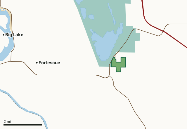
MDC conservation areasNational wildlife refugesState parks and historic sitesLand trusts and other open landJamerson C. McCormack Conservation AreaCounty lineLakeHighway
| Size | 223 acres |
|---|---|
| County | Holt County |
| Deer harvest unit | Holt County |
| MDC lists for hunting | Deer, Turkey and Squirrel |
| MDC area number | 7611 |
| MDC region | Northwest |
| Camping (MDC) | designated camping sites |
| Nearest towns | Fortescue (4 mi), Bigelow (5 mi) and Forest City (5 mi) |
What is Jamerson C. McCormack Conservation Area like?
Jamerson C. McCormack Conservation Area is in central Holt County, about five miles northeast of the junction of the Missouri-Kansas-Nebraska state lines. Mound City is five miles north of the area, and Loess Bluff National Wildlife Refuge borders the area to the west. The area can be reached via I-29 to Loess Bluff exit, then three miles south on Highway 159.
This conservation area was created in 1966 with a gift of 158 acres to The Nature Conservancy from Jamerson C. McCormack. The land was later leased to the Conservation Department. In 1977 Jamerson C. and Carson McCormack donated 67 acres to the Department, increasing the area to its present 227 acres. Prevailing winds during the last glacial period deposited wind-blown soil into mounds nearly 100-feet thick on this area. Called "loess," this soil is characteristic of the Missouri River bluffs in this vicinity. Erosion of mounds of wind blown loess soil well over 100 feet deep has created a steep and rugged landscape. The western portion of the area is a designated Missouri Natural Area. Loess hill prairies found on the ridgetops here support eight plants at the edge of their range. Listed in the Missouri Species of Conservation Concern Checklist, these plants are more common on the arid...
In MDC's words, from the Jamerson C. McCormack Conservation Area page.
What can you hunt on Jamerson C. McCormack Conservation Area?
MDC's page for Jamerson C. McCormack Conservation Area lists: Deer: muzzleloader and archery, antlerless permits not allowed; Turkey: archery and firearms; Squirrel.
What are the rules on Jamerson C. McCormack Conservation Area?
MDC's standard conservation area rules (Chapter 11 of the Wildlife Code) apply; the area's rules on MDC's site list any it adds.
How many deer are taken around Jamerson C. McCormack Conservation Area?
Jamerson C. McCormack Conservation Area lies in Holt County. Hunters checked 849 deer in Holt County in 2025, against 846 in 2024.
| County | Jamerson C. McCormack Conservation Area acres in it | Deer, 2025 | Deer, 2024 | Deer, 2023 |
|---|---|---|---|---|
| Holt County | 223 | 849 | 846 | 835 |
Harvest for the whole county, not the conservation area alone: MDC deer harvest summaries (2021 to 2025 seasons).
How do you get to Jamerson C. McCormack Conservation Area?
MDC's directions: South of Mound City at I-29 Exit 79, take Highway 159 south 3 miles to area.
Nearest towns: Fortescue (4 miles), Bigelow (5 miles), Forest City (5 miles) and Mound City (6 miles). Highways within 5 miles: I-29, US 159, MO 111, US 59 and MO 118.
What other public land is near Jamerson C. McCormack Conservation Area?
MDC lands within 10 miles:
- Bob Brown Conservation Area: 3,362 acres, 3.9 miles away
- Wolf Creek Bend Conservation Area: 983 acres, 7.6 miles away
- Riverbreaks Conservation Area: 2,275 acres, 7.6 miles away
- Rush Bottoms Conservation Area: 1,095 acres, 8.1 miles away
- Nodaway Valley Conservation Area: 3,961 acres, 8.1 miles away
Public land within 3 miles of Jamerson C. McCormack Conservation Area
Counting Jamerson C. McCormack Conservation Area itself, 4,690 of the 23,381 acres within 3 miles of its boundary are public land open to the public (20.1%), by USGS PAD-US 4.1 and MDC conservation area boundaries.
| Manager | Acres within 3 miles |
|---|---|
| National wildlife refuges | 4,445 |
| MDC conservation areas | 223 |
| Land trusts and other open land | 22 |
Questions hunters ask
Where is Jamerson C. McCormack Conservation Area?
In Holt County, 4 miles from Fortescue.
Can you deer hunt on Jamerson C. McCormack Conservation Area?
Yes, by MDC's page: muzzleloader and archery, antlerless permits not allowed.
How much public land is around Jamerson C. McCormack Conservation Area?
4,690 acres within 3 miles of its boundary, Jamerson C. McCormack Conservation Area included, by USGS PAD-US 4.1 and MDC conservation area boundaries. The closest other MDC area is Bob Brown Conservation Area (3.9 miles).
Get a Missouri hunt plan when they open
Hunt plans for Missouri are coming. Join the list and you'll hear first. The first 50 hunters in each new state get their plan free.
Until then, the free FilledTag app for iPhone has a map that works in every state, Missouri included.
Where these facts come from
- Area description, species, rules and directions: MDC, Jamerson C. McCormack Conservation Area; MDC conservation area boundaries.
- Boundary and acres: MDC's map layer above. Surrounding public land: USGS PAD-US 4.1 (fee land open to the public) and MDC conservation area boundaries.
- Deer harvest: MDC deer harvest summaries (2021 to 2025 seasons).
FilledTag is not part of the Missouri Department of Conservation. Check MDC's rules and posted signs before you go.