Sand Pond Conservation Area: hunting and access
Sand Pond Conservation Area is 302 acres of MDC land in Ripley County, 4 miles from Naylor. MDC lists deer hunting here (archery only, antlerless permits allowed). Hunters checked 3,088 deer in Ripley County in 2025.
Data updated October 2026. Area facts: MDC's conservation area data, read 2026-10. Harvest: MDC deer harvest summaries, 2021 to 2025.
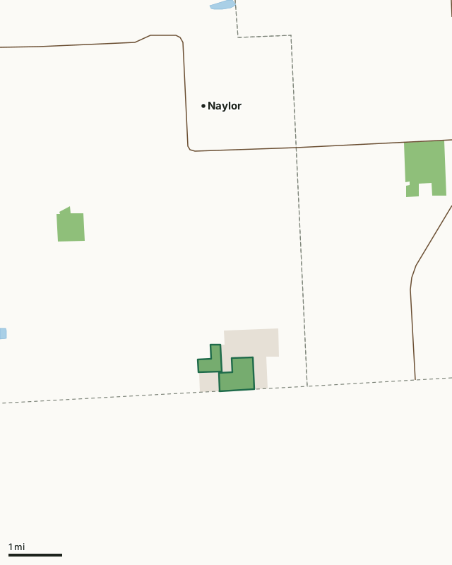
MDC conservation areasLand trusts and other open landSand Pond Conservation AreaCounty lineLakeHighway
| Size | 302 acres (202 by MDC's page) in 2 pieces |
|---|---|
| County | Ripley County |
| Deer harvest unit | Ripley County |
| MDC lists for hunting | Deer, Bear, Turkey, Rabbit and Squirrel |
| MDC area number | 8113 |
| MDC region | Ozark |
| Camping (MDC) | open camping - walk-in/float-in/backpack |
| Nearest towns | Naylor (4 mi), Neelyville (6 mi) and Oxly (7 mi) |
What is Sand Pond Conservation Area like?
Sand Pond Conservation Area is located in southeastern Ripley County, 4.5 miles south of Naylor on Route W. The area contains 302 acres. The Nature Conservancy owns an additional 500 acres in Missouri and 160 acres in Arkansas that are adjacent to the area.
Sand Pond Conservation Area was purchased primarily to protect the unique dune-swale ecosystem found here, but the area also offers good opportunities for hunting, hiking, wildlife viewing, and other recreational opportunities. The sandy soils that characterize the area were deposited here by the waters of melting glaciers during the Late Wisconsin Stage. Then, about 18,000 to 22,000 years ago, winds swept the land and formed these sands into dunes and swales, or ponds. The ponds and their banks support many rare and endangered species, including corkwood and a federally endangered shrub called pondberry. Native Americans occupied the dunes between 5,000 B.C. and 1350 A.D. In the early 1900s, European settlers cleared the dunes for farming. We have planted trees in these fields to help restore the dunes to their natural condition. Over time, the dunes will begin to support more of the...
In MDC's words, from the Sand Pond Conservation Area page.
What can you hunt on Sand Pond Conservation Area?
MDC's page for Sand Pond Conservation Area lists: Deer: archery only, antlerless permits allowed; Bear: archery and firearms; Turkey: archery and firearms; Rabbit; Squirrel.
What are the rules on Sand Pond Conservation Area?
MDC's standard conservation area rules (Chapter 11 of the Wildlife Code) apply; the area's rules on MDC's site list any it adds.
How many deer are taken around Sand Pond Conservation Area?
Sand Pond Conservation Area lies in Ripley County. Hunters checked 3,088 deer in Ripley County in 2025, against 2,848 in 2024.
| County | Sand Pond Conservation Area acres in it | Deer, 2025 | Deer, 2024 | Deer, 2023 |
|---|---|---|---|---|
| Ripley County | 302 | 3,088 | 2,848 | 3,818 |
Harvest for the whole county, not the conservation area alone: MDC deer harvest summaries (2021 to 2025 seasons).
How do you get to Sand Pond Conservation Area?
MDC's directions: From Naylor, take Highway 142 south 1 mile, then Route W south 4 miles.
Nearest towns: Naylor (4 miles), Neelyville (6 miles), Oxly (7 miles) and Fairdealing (11 miles). Highways within 5 miles: MO 142 and US 67.
What other public land is near Sand Pond Conservation Area?
MDC lands within 10 miles:
- Hemenway Conservation Area: 173 acres, 3 miles away
- Corkwood Conservation Area: 442 acres, 4.1 miles away
- Big Cane Conservation Area: 2,138 acres, 5 miles away
- Fourche Creek Conservation Area: 3,782 acres, 9.4 miles away
- Allred Lake Natural Area: 165 acres, 9.5 miles away
- Coon Island Conservation Area: 3,179 acres, 10 miles away
Public land within 3 miles of Sand Pond Conservation Area
Counting Sand Pond Conservation Area itself, 852 of the 24,648 acres within 3 miles of its boundary are public land open to the public (3.5%), by USGS PAD-US 4.1 and MDC conservation area boundaries.
| Manager | Acres within 3 miles |
|---|---|
| Land trusts and other open land | 550 |
| MDC conservation areas | 302 |
Questions hunters ask
Where is Sand Pond Conservation Area?
In Ripley County, 4 miles from Naylor.
Can you deer hunt on Sand Pond Conservation Area?
Yes, by MDC's page: archery only, antlerless permits allowed.
How much public land is around Sand Pond Conservation Area?
852 acres within 3 miles of its boundary, Sand Pond Conservation Area included, by USGS PAD-US 4.1 and MDC conservation area boundaries. The closest other MDC area is Hemenway Conservation Area (3 miles).
Get a Missouri hunt plan when they open
Hunt plans for Missouri are coming. Join the list and you'll hear first. The first 50 hunters in each new state get their plan free.
Until then, the free FilledTag app for iPhone has a map that works in every state, Missouri included.
Where these facts come from
- Area description, species, rules and directions: MDC, Sand Pond Conservation Area; MDC conservation area boundaries.
- Boundary and acres: MDC's map layer above. Surrounding public land: USGS PAD-US 4.1 (fee land open to the public) and MDC conservation area boundaries.
- Deer harvest: MDC deer harvest summaries (2021 to 2025 seasons).
FilledTag is not part of the Missouri Department of Conservation. Check MDC's rules and posted signs before you go.