Monroe County, Ohio: deer harvest and public hunting land
Monroe County covers 457 square miles around Woodsfield. Hunters checked 2,195 deer here in the 2025-26 season, 689 of them by archers, by the Division of Wildlife's final report. That is down 32% from 2024, and the fewest in the 4 years shown. 10.6% of Monroe County is public land open to the public, the largest share national forest (24,654 acres), by USGS PAD-US 4.1 and ODNR's land boundaries.
Data updated October 2026. Harvest: the Division of Wildlife's harvest reports, 2021-22 to 2025-26. Land: PAD-US 4.1 and ODNR's land layer.
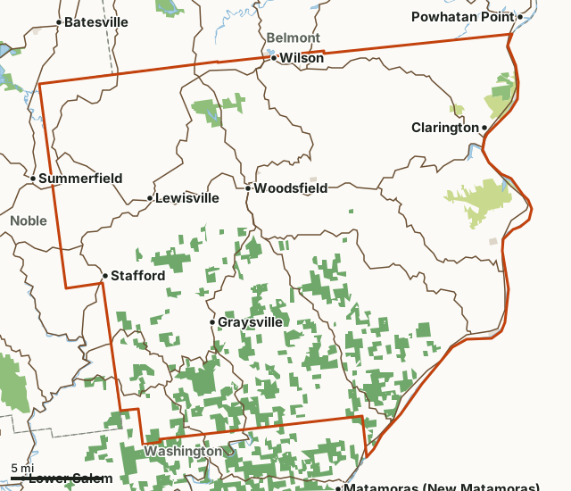
Land on ODNR's hunting mapNational forestOther state landMetro parks, county and city landLand trusts and other open landMonroe CountyNeighboring countiesLakeHighway
| Size | 292,775 acres (457 square miles) |
|---|---|
| Deer checked, 2025-26 | 2,195 (922 antlered, 1,273 antlerless) |
| Archery and gun, 2025-26 | 689 archery, 1,506 gun |
| Public land | 10.6% (30,978 acres) |
| ODNR hunting areas | 2 (1,978 acres inside Monroe County) |
| Towns in and near it | Woodsfield, Clarington, Graysville, Summerfield, Powhatan Point and Matamoras (New Matamoras) |
How many deer are harvested in Monroe County?
Hunters checked 2,195 deer in Monroe County in 2025-26: 922 antlered and 1,273 antlerless. Archers took 689 and gun hunters 1,506.
| Season | Deer checked | Antlered | Antlerless | Archery | Gun |
|---|---|---|---|---|---|
| 2025-26 | 2,195 | 922 | 1,273 | 689 | 1,506 |
| 2024-25 | 3,224 | 1,406 | 1,818 | 1,085 | 2,139 |
| 2023-24 | 2,878 | 1,304 | 1,574 | 1,098 | |
| 2021-22 | 2,477 |
Source: the Division of Wildlife's 2025-26, 2024-25 and 2023-24 final deer harvest reports and Publication 5304 (2021-22), Monroe County. 2022-23 is not shown. For 2021-22 Publication 5304 gives 1,261 bucks, 1,026 does and 190 button bucks; the final reports of later seasons count bucks with shed or very short antlers as antlerless.
How much public land is in Monroe County?
30,978 of Monroe County's 292,775 acres are public land open to the public (10.6%). The biggest share is national forest: 24,654 acres.
| Manager | Acres | Share of Monroe County |
|---|---|---|
| National forest | 24,654 | 8.4% |
| Other state land | 3,942 | 1.3% |
| Land on ODNR's hunting map | 1,978 | 0.7% |
| Metro parks, county and city land | 257 | 0.1% |
| Land trusts and other open land | 147 | 0.1% |
| All public land open to the public | 30,978 | 10.6% |
Measured by FilledTag inside the county line from USGS PAD-US 4.1 (fee land open to the public) and ODNR's land boundaries with hunting status. Hunting rules differ by manager: ODNR wildlife areas, hunting areas and forests marked open follow Ohio's statewide seasons, and those marked restricted limit hunting by place, season or permit; national forest is open; refuges follow U.S. Fish and Wildlife Service rules; Corps of Engineers lake land is open in many places under each project's own rules; metro parks and city land are closed to most hunting.
ODNR areas open to hunting in Monroe County
ODNR areas open to hunting in Monroe County, largest first, with the acres of each inside it:
- Monroe Lake Wildlife Area: 1,341 acres
- Sunfish Creek State Forest: 637 acres
Other large public areas here, by PAD-US: Wayne National Forest (24,654 acres).
How do you get to Monroe County?
Highways through it: OH 78 (about 32 miles inside), OH 7 (about 31 miles inside), OH 26 (about 31 miles inside), OH 800 (about 26 miles inside) and OH 145 (about 26 miles inside). Towns inside: Woodsfield, Clarington, Graysville, Wilson, Lewisville and Beallsville. Nearby: Summerfield (on the line), Powhatan Point (on the line), Matamoras (New Matamoras) (2 miles) and Batesville (3 miles).
Which counties border Monroe County?
Monroe County touches 3 other counties. Their latest ODNR harvest and public land, for comparison:
| County | Deer harvested | Year | Public land |
|---|---|---|---|
| Noble County | 2,260 | 2025 | 12.5% |
| Belmont County | 3,725 | 2025 | 7.8% |
| Washington County | 783 | 2025 | 10.9% |
Questions hunters ask
How many deer were harvested in Monroe County in 2025-26?
2,195: 922 antlered and 1,273 antlerless (Division of Wildlife). In 2024-25: 3,224.
Is there public hunting land in Monroe County?
30,978 acres, 10.6% of the county, are public land open to the public by USGS PAD-US 4.1 and ODNR's land boundaries, the largest share national forest (24,654 acres). ODNR's layer shows 2 areas open to hunting here.
How many deer do archers take in Monroe County?
689 of the 2,195 deer checked in 2025-26 were taken with a crossbow or longbow (Division of Wildlife).
Get a Ohio hunt plan when they open
Hunt plans for Ohio are coming. Join the list and you'll hear first. The first 50 hunters in each new state get their plan free.
Until then, the free FilledTag app for iPhone has a map that works in every state, Ohio included.
Where these numbers come from
- Deer harvest: the Division of Wildlife's 2025-26, 2024-25 and 2023-24 final deer harvest reports and Publication 5304 (2021-22).
- Public land: USGS PAD-US 4.1 (fee land open to the public) and ODNR's land boundaries with hunting status. ODNR areas open to hunting: ODNR lands hunting status.
- Boundaries: U.S. Census Bureau 2024 cartographic county boundaries. Highways and towns: U.S. Census Bureau TIGER/Line 2024 primary and secondary roads; U.S. Census Bureau 2024 Gazetteer, places.
FilledTag is not part of the Ohio Department of Natural Resources, Division of Wildlife. Numbers are copied from ODNR and the federal sources above, or measured from their maps; nothing on this page is estimated by FilledTag.