Kershaw County deer harvest: South Carolina, 2019 to 2024
SCDNR's 2024 Deer Harvest Report puts Kershaw County's harvest at 5,103 deer: 2,635 antlered bucks, 205 button bucks, 1,969 does and 295 of unknown sex, reported through SC Game Check and corrected by SCDNR for hunters who did not report. That is 9.1 deer per square mile of deer habitat. Ordered by SCDNR's 2024 harvest figures, the county is 11th of 46 by total deer and 19th by deer per square mile. About 4,978 deer hunters spent 73,476 days hunting deer in the county. SCDNR's survey estimates for 2019 to 2023 run from 3,466 (2022) to 5,797 (2019). The county is in Game Zone 4.
Data updated October 2026. Harvest: SCDNR Deer Harvest Reports, 2019 to 2024. Seasons: SCDNR's 2026-27 deer seasons on private lands.
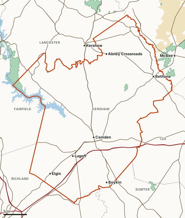
Kershaw CountySCDNR WMAsNational wildlife refugeLake or riverHighwayCounty line
| Deer, 2024 season | 5,103: 2,635 antlered, 205 button bucks, 1,969 does, 295 unknown |
|---|---|
| Per square mile of deer habitat | 9.1, 19th of 46 |
| Place by SCDNR's total, 2024 | 11th of 46 counties |
| Deer hunters, 2024 | 4,978 (15th of 46), 14.8 days each on average |
| Days of deer hunting, 2024 | 73,476 (9th of 46) |
| Hogs taken by deer hunters, 2024 | 1,161 (2.1 per square mile) |
| Coyotes taken by deer hunters, 2024 | 675 |
| Game zone | Zone 4 |
| Deer habitat (SCDNR) | 360,485 acres |
| Public land mapped here | 2 WMA properties with a page, 1,973 acres |
| Towns | Camden, Bethune and Elgin |
How many deer are killed in Kershaw County each season?
| Season | Deer | Bucks | Does | Per sq mi of habitat | How SCDNR counted |
|---|---|---|---|---|---|
| 2024 | 5,103 | 2,840 | 1,969 | 9.1 | Reported (SC Game Check, corrected) |
| 2023 | 4,363 | 2,724 | 1,639 | 7.7 | Survey estimate |
| 2022 | 3,466 | 1,959 | 1,507 | 6.2 | Survey estimate |
| 2021 | 4,790 | 2,601 | 2,189 | 8.5 | Survey estimate |
| 2020 | 5,764 | 3,333 | 2,431 | 10.2 | Survey estimate |
| 2019 | 5,797 | 3,159 | 2,638 | 10.3 | Survey estimate |
Source: SCDNR 2024 Deer Harvest Report, Table 1 (county harvest) and Table 1 of the 2019 to 2023 reports (SCDNR deer harvest reports). In 2024 SCDNR moved from a hunter survey to mandatory reporting through SC Game Check, so compare 2024 with the years before it with care. 2024 bucks are antlered and button bucks added together by FilledTag; the 295 deer of unknown sex are in the total only. Per square mile is SCDNR's own figure, on the forest and crop land it counts as deer habitat.
How many people hunt deer in Kershaw County?
SCDNR estimates 4,978 people hunted deer in Kershaw County in the 2024 season, 15th of 46 counties, averaging 14.8 days each for 73,476 days in all (9th of 46).
The same report estimates deer hunters took 1,161 wild hogs (2.1 per square mile) and 675 coyotes (1.2 per square mile) in the county in 2024.
Source: SCDNR 2024 Deer Harvest Report, Table 5 (hunters and days by county); SCDNR 2024 Deer Harvest Report, Table 10 (hogs and coyotes by county). These are survey estimates.
When is deer season in Kershaw County?
Kershaw County is in Game Zone 4. Game Zone 4 is Clarendon, Chesterfield, Darlington, Dillon, Florence, Georgetown, Horry, Kershaw, Lee, Marion, Marlboro, Sumter and Williamsburg counties.
Game Zone 4, private land
| Archery only | Aug. 15-31 (buck only) |
|---|---|
| Gun hunts | Sept. 1-Jan. 1 (Sept. 1-14 buck only) |
| Youth deer days | Aug. 8 (antlered only, 1 deer); Jan. 2 (either sex, 2 deer) |
| Antlerless limit | 2 a day, 9 total all seasons and methods |
Dogs are allowed for deer on private land in Game Zone 4. Baiting deer is allowed on private land statewide and Sunday hunting is allowed on private land. WMAs set their own dates.
Source: SCDNR 2026-27 deer seasons on private lands.
Where is the public hunting land in Kershaw County?
| WMA property | Acres in Kershaw County | First deer hunt, 2026-27 | Deer reported, 2024 |
|---|---|---|---|
| Liberty Hill WMA | 1,509 | Sept. 15-30 (archery, Lancaster County side, Game Zone 2) | 32 |
| Sand Hills State Forest WMA | 464 | Sept. 15-Oct. 10 (archery) | 151 |
Acres measured by FilledTag on SCDNR Public Lands property boundaries, U.S. Forest Service land ownership and U.S. Fish and Wildlife Service refuge boundaries. WMA harvest: SCDNR 2024 Deer Harvest Report, Table 4 (WMA harvest).
How does Kershaw County compare with its neighbors?
| County | Deer, 2024 | Antlered bucks | Per sq mi of habitat |
|---|---|---|---|
| Kershaw County | 5,103 | 2,635 | 9.1 |
| Chesterfield County | 4,479 | 2,356 | 7.7 |
| Darlington County | 3,969 | 1,894 | 8.9 |
| Fairfield County | 4,197 | 2,215 | 7 |
| Lancaster County | 4,407 | 2,198 | 10.6 |
| Lee County | 3,109 | 1,353 | 9 |
| Richland County | 2,884 | 1,462 | 5.4 |
| Sumter County | 4,808 | 2,323 | 9.1 |
All from SCDNR 2024 Deer Harvest Report, Table 1 (county harvest).
Questions hunters ask
How many deer were killed in Kershaw County, South Carolina last season?
5,103 in the 2024 season, by SCDNR's Deer Harvest Report: 2,635 antlered bucks, 205 button bucks, 1,969 does and 295 of unknown sex. These are SC Game Check reports corrected by SCDNR for hunters who did not report.
How does Kershaw County's deer harvest compare with other South Carolina counties?
SCDNR puts Kershaw County's 2024 harvest at 5,103 deer, 9.1 per square mile of deer habitat against 8.7 statewide. Ordered by SCDNR's harvest figures, that is 11th of 46 counties by total deer and 19th by deer per square mile.
When is deer season in Kershaw County?
On private land: Game Zone 4, archery only Aug. 15-31 (buck only); gun hunts Sept. 1-Jan. 1 (Sept. 1-14 buck only). WMAs set their own dates.
Is there public hunting land in Kershaw County?
Yes. SCDNR's map puts Liberty Hill WMA (1,509 acres in the county) and Sand Hills State Forest WMA (464 acres in the county) in Kershaw County.
Can you hunt deer with dogs in Kershaw County?
Yes, on private land, as the Game Zone 4 seasons allow. On WMAs, only on the dog drive hunt dates an area lists.
Get a South Carolina hunt plan when they open
South Carolina plans are not open yet. They are coming soon. Join the waiting list; the first 50 hunters get one plan free.
Use the map while you wait for your plan.
Where these numbers come from
- Deer harvest, hunters, days, hogs and coyotes: SCDNR 2024 Deer Harvest Report and earlier reports (SCDNR deer harvest reports).
- Seasons and rules: SCDNR 2026-27 deer seasons on private lands. Public land: SCDNR Public Lands property boundaries. Counties, highways and towns: U.S. Census Bureau 2024 county boundaries; U.S. Census Bureau TIGER/Line 2024 roads; U.S. Census Bureau 2024 Gazetteer.
FilledTag is not part of the South Carolina Department of Natural Resources. Numbers are copied from SCDNR and the Census Bureau or measured from public maps; nothing here is estimated by FilledTag.
South Carolina hunting South Carolina deer harvest by county Chesterfield County Darlington County Fairfield County Lancaster County