Santee Coastal Reserve WMA: 2026-27 seasons, rules and map
Santee Coastal Reserve WMA is 23,310 acres of public hunting land in Charleston and Georgetown counties, owned by SCDNR, in Game Zone 3. Hunters reported 4 deer taken on it in the 2024 season (3 antlered bucks and 1 doe), by SCDNR's Deer Harvest Report. Its 2026-27 deer seasons are set on SCDNR's Game Zone 3 table: archery; the earliest dated hunt is Sept. 15-Jan. 1 (archery).
Data updated October 2026. Seasons: SCDNR's 2026-27 Game Zone 3 WMA table. Harvest: SCDNR's 2024 Deer Harvest Report.
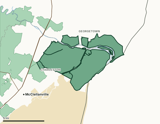
Santee Coastal Reserve WMAOther SCDNR WMAsNational forestNational wildlife refugeLake or riverHighwayCounty line
| Size | 23,310 acres (measured by FilledTag on SCDNR's mapped boundary); SCDNR's 2024 harvest report gives 4,000 |
|---|---|
| County | Charleston County, Georgetown County |
| Game zone | Zone 3 |
| Deer hunts | Archery |
| Archery deer | Sept. 15-Jan. 1 |
| Dogs for deer | No dog drive hunts listed for the area |
| Spring turkey | April 3 to May 3 (Saturdays only), limit 1 |
| Deer reported, 2024 season | 4 (3 antlered bucks and 1 doe) |
| Phone | (843) 546-8665 |
| Nearest towns | McClellanville (4 mi), Georgetown (14 mi) and Awendaw (17 mi) |
When are the 2026-27 seasons on Santee Coastal Reserve WMA?
- Hunting is allowed on the mainland only.
| Hunt | Dates, 2026-27 | Limits |
|---|---|---|
| Deer Archery | Sept. 15-Jan. 1 | Statewide WMA limits |
| Hog Still Gun Hunts | Mar. 2-18 Refer to Reg. 2.16. | No Limit |
| Hog Hunts (with Dogs) | Mar. 19-26 Refer to Reg. 2.16. | No Limit |
| Small Game (including raccoon and opossum) | Nov. 26-Mar. 1 No fox squirrel hunting | Statewide limits |
Source: SCDNR 2026-27 Game Zone 3 WMA seasons, read October 2026. SCDNR's rules are the final word.
When is turkey season on Santee Coastal Reserve WMA?
Santee Coastal Reserve WMA is on SCDNR's list of WMAs open for spring turkey, April 3 to May 3, 2027: Saturdays only, limit 1 gobbler.
Source: SCDNR spring 2027 turkey seasons on WMAs.
How many deer are taken on Santee Coastal Reserve WMA?
Hunters reported 4 deer on Santee Coastal Reserve WMA in the 2024 season: 3 antlered bucks and 1 doe. SCDNR's Table 4 counts the area as 4,000 acres (SCDNR's figure, not the measured size above), about one deer for every 1,000 acres on that figure.
Source: SCDNR 2024 Deer Harvest Report, Table 4 (WMA harvest).
What does SCDNR say about Santee Coastal Reserve WMA?
From SCDNR's property page: "Santee Coastal Reserve (SCR) Wildlife Management Area was established by the South Carolina Department of Natural Resources as a result of the purchase and donation of the property by The Nature Conservancy in 1974. This unique property represents a variety of habitats found in South Carolina including diverse uplands, freshwater, brackish and tidal wetlands, and agricultural fields. The SCR property is composed of Murphy Island, Cedar Island, The Cape, Washo Reserve, and adjacent upland habitats."
Closures for hunts: The area is closed to visitors during scheduled hunts. Managed wetlands will be open for wildlife observation, bird watching, photography, or nature study during daylight hours (1/2 hour before sunrise to 1/2 hour after sunset) from February 9 through October 31 each year except during special hunts and events regulated by the Department.
Visiting hours: The Santee Coastal Reserve is open during daylight hours (1/2 hour before sunrise to 1/2 hour after sunset) for limited public use year round except during annually scheduled hunts. Notice of the hunts will be issued annually. Please note that Murphy and Cedar Islands and their beaches are not accessible from the mainland. Visitors must provide their own transportation via watercraft.
Source: SCDNR Public Lands, Santee Coastal Reserve WMA, read October 2026.
Which county is Santee Coastal Reserve WMA in, and what do hunters take there?
| County | Acres of the area in it | County deer, 2024 season | Per square mile of deer habitat |
|---|---|---|---|
| Charleston County | 17,934 | 2,905 | 6.4 |
| Georgetown County | 5,376 | 3,845 | 6.2 |
Acres measured by FilledTag on SCDNR Public Lands property boundaries and the U.S. Census Bureau 2024 county boundaries. County harvest: SCDNR 2024 Deer Harvest Report, Table 1 (county harvest), for the whole county.
How do you get to Santee Coastal Reserve WMA?
Highways within 5 miles: US 17, US 701 and SC 45. Nearest towns: McClellanville (4 miles), Georgetown (14 miles), Awendaw (17 miles) and Jamestown (18 miles). SCDNR's number for the area: (843) 546-8665.
The closest other South Carolina WMAs with a page here: Francis Marion National Forest WMA (next to it), Santee Delta WMA (next to it), Santee Island WMA (3.3 miles) and Wee Tee WMA (13.8 miles).
Questions hunters ask
When is deer season on Santee Coastal Reserve WMA in 2026-27?
Deer Archery: Sept. 15-Jan. 1. From SCDNR's 2026-27 Game Zone 3 table.
Can you hunt deer with dogs on Santee Coastal Reserve WMA?
No dog drive hunts are listed for Santee Coastal Reserve WMA on SCDNR's 2026-27 table, so deer are hunted without dogs there.
Can you hunt turkeys on Santee Coastal Reserve WMA?
Yes. It is on SCDNR's list of WMAs open for spring turkey, April 3 to May 3, 2027: Saturdays only, limit 1 gobbler.
What county is Santee Coastal Reserve WMA in?
Charleston County (17,934 acres) and Georgetown County (5,376 acres), measured on SCDNR's boundary.
How many deer were killed on Santee Coastal Reserve WMA last season?
4 in the 2024 season, reported through SC Game Check and corrected by SCDNR for non-reporting: 3 antlered bucks and 1 doe.
Get a South Carolina hunt plan when they open
South Carolina plans are not open yet. They are coming soon. Join the waiting list; the first 50 hunters get one plan free.
Use the map while you wait for your plan.
You need a South Carolina hunting license, a WMA permit and big game tags; statewide WMA limit: 2 deer a day, 5 in all, no more than 2 antlered, unless the area's rules say otherwise; antlerless deer 2 a day. The WMA rules on one page. FilledTag is not part of the South Carolina Department of Natural Resources; numbers are copied from SCDNR or measured from public maps, each with its source above.
South Carolina hunting All South Carolina WMAs Charleston County deer harvest Georgetown County deer harvest