Sumter National Forest Enoree Ranger District: 2026-27 seasons, rules and map
Sumter National Forest Enoree Ranger District is 160,612 acres of public hunting land in Union, Newberry, Laurens, Chester and Fairfield counties, U.S. Forest Service land in SCDNR's WMA program, in Game Zone 2. Its 2026-27 deer seasons are set on SCDNR's Game Zone 2 table: archery, primitive weapons and still gun hunts; the earliest dated hunt is Sept. 15-30 (archery).
Data updated October 2026. Seasons: SCDNR's 2026-27 Game Zone 2 WMA table. Harvest: SCDNR's 2024 Deer Harvest Report.
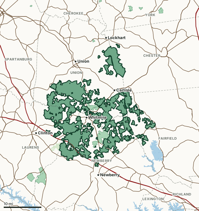
Sumter National Forest Enoree Ranger DistrictOther SCDNR WMAsNational forestLake or riverHighwayCounty line
| Size | 160,612 acres (measured by FilledTag on SCDNR's mapped boundary) |
|---|---|
| County | Union County, Newberry County, Laurens County, Chester County, Fairfield County |
| Game zone | Zone 2 |
| National forest land in it | 160,419 acres (measured on the Forest Service map) |
| Deer hunts | Archery, primitive weapons and still gun hunts |
| Archery deer | Sept. 15-30 |
| Still gun deer | Oct. 12-Jan. 1 |
| Dogs for deer | No; deer hunting with dogs is unlawful in Game Zones 1 and 2 |
| Spring turkey | April 3 to May 3, limit 2 (regular WMA season) |
| Sunday hunting | Allowed October 15 to January 31 for species in season |
| Phone | (864) 654-1671 |
| Nearest towns | Whitmire (next to it), Carlisle (next to it) and Newberry (2 mi) |
When are the 2026-27 seasons on Sumter National Forest Enoree Ranger District?
- * Abbeville, Chester, Edgefield, Fairfield, Greenwood, Laurens, McCormick, Newberry, Saluda, Union Counties. Hunting is allowed on Sundays Oct. 15-Jan. 31 for species that are in season and listed below. No waterfowl hunting on Sunday.
| Hunt | Dates, 2026-27 | Limits |
|---|---|---|
| Deer Archery | Sept. 15-30 | statewide WMA limits; all deer must be tagged |
| Deer Primitive Weapons | Oct. 1-10 | statewide WMA limits; all deer must be tagged |
| Deer Still Gun Hunts | Oct. 12-Jan. 1 | statewide WMA limits; all deer must be tagged |
| Small Game | Game Zone 2 WMA seasons and limits. | Statewide limits |
| Hog Hunts (with dogs) | Jan. 2-9, Mar. 20-27 | No limit |
| Raccoon & Opossum | Game Zone 2 WMA seasons and limits. |
Source: SCDNR 2026-27 Game Zone 2 WMA seasons, read October 2026. SCDNR's rules are the final word.
When is turkey season on Sumter National Forest Enoree Ranger District?
SCDNR opens the regular WMAs in all four game zones, Forest Service land included, for spring turkey April 3 to May 3, 2027, limit 2 gobblers.
Source: SCDNR spring 2027 turkey seasons on WMAs.
How many deer are taken on Sumter National Forest Enoree Ranger District?
SCDNR reports Sumter National Forest Enoree Ranger District together with Sumter National Forest Andrew Pickens Ranger District and Sumter National Forest Long Cane Ranger District as "USFS Sumter National Forest": 1,439 deer in the 2024 season on 375,000 acres (790 antlered bucks, 91 button bucks and 558 does). The figure is for all of that land, not this part alone.
Source: SCDNR 2024 Deer Harvest Report, Table 4 (WMA harvest).
What does SCDNR say about Sumter National Forest Enoree Ranger District?
From SCDNR's property page: "Within the Enoree Ranger District, there are special areas managed for waterfowl that include the Duncan Creek Waterfowl Management Area in Laurens County, the Enoree River Waterfowl Management Area in Newberry County, and Dunaway and Tyger River Waterfowl Management Areas in Union County. There are also public dove fields that include the Worthy’s Bottom Field in Chester County, Newberry Field in Newberry County, and the Sedalia and Herbert fields in Union County. The opening day hunt at both the Newberry and Sedalia Fields is reserved for special youth dove hunts."
- Sumter National Forest is a Category II Waterfowl Area.
Source: SCDNR Public Lands, Sumter National Forest - Enoree Ranger District, read October 2026.
Which county is Sumter National Forest Enoree Ranger District in, and what do hunters take there?
| County | Acres of the area in it | County deer, 2024 season | Per square mile of deer habitat |
|---|---|---|---|
| Union County | 61,379 | 3,929 | 9.7 |
| Newberry County | 54,033 | 3,896 | 7.8 |
| Laurens County | 21,421 | 5,891 | 11.9 |
| Chester County | 12,704 | 4,089 | 8.7 |
| Fairfield County | 11,075 | 4,197 | 7 |
Acres measured by FilledTag on SCDNR Public Lands property boundaries and the U.S. Census Bureau 2024 county boundaries. County harvest: SCDNR 2024 Deer Harvest Report, Table 1 (county harvest), for the whole county.
How do you get to Sumter National Forest Enoree Ranger District?
Highways through the area: I-26, SC 121, SC 72 and US 176. Nearest towns: Whitmire (next to it), Carlisle (next to it), Newberry (2 miles) and Lockhart (3 miles). SCDNR's number for the area: (864) 654-1671.
The closest other South Carolina WMAs with a page here: Delta South WMA (next to it), Indian Creek Quail Focal Area (next to it), Thurmond Tract WMA (3.2 miles) and Belfast WMA (6.1 miles).
Questions hunters ask
When is deer season on Sumter National Forest Enoree Ranger District in 2026-27?
Deer Archery: Sept. 15-30; Deer Primitive Weapons: Oct. 1-10; Deer Still Gun Hunts: Oct. 12-Jan. 1. From SCDNR's 2026-27 Game Zone 2 table.
Can you hunt deer with dogs on Sumter National Forest Enoree Ranger District?
No. Hunting deer with dogs is unlawful in Game Zones 1 and 2.
Can you hunt turkeys on Sumter National Forest Enoree Ranger District?
Yes, in SCDNR's regular WMA season, April 3 to May 3, 2027, limit 2 gobblers, no more than 1 a day and 1 before April 10.
What county is Sumter National Forest Enoree Ranger District in?
Union County (61,379 acres), Newberry County (54,033 acres), Laurens County (21,421 acres), Chester County (12,704 acres) and Fairfield County (11,075 acres), measured on SCDNR's boundary.
Get a South Carolina hunt plan when they open
South Carolina plans are not open yet. They are coming soon. Join the waiting list; the first 50 hunters get one plan free.
Use the map while you wait for your plan.
You need a South Carolina hunting license, a WMA permit and big game tags; statewide WMA limit: 2 deer a day, 5 in all, no more than 2 antlered, unless the area's rules say otherwise; antlerless deer 2 a day. The WMA rules on one page. FilledTag is not part of the South Carolina Department of Natural Resources; numbers are copied from SCDNR or measured from public maps, each with its source above.
South Carolina hunting All South Carolina WMAs Union County deer harvest Newberry County deer harvest Laurens County deer harvest