J.D. Murphree WMA: public hunting, 2026-27 seasons and access
J.D. Murphree WMA is 25,258 acres of public hunting land in Jefferson County, Texas, TPWD units #783N and #783S. Adults hunt it on the $48 Annual Public Hunting Permit and register on site each day, in the Texas Hunt & Fish app (eOSR). TPWD's 2026-27 map booklet lists feral hog among the legal game, along with waterfowl, early teal, south zone duck and geese, rails, gallinule, and snipe. Some units have closure dates of their own, listed with each unit below.
Data updated October 2026. Seasons and rules: TPWD's 2026-27 Map Booklet for Public Hunting Lands. Boundaries: TPWD's Public Hunt Locator map.
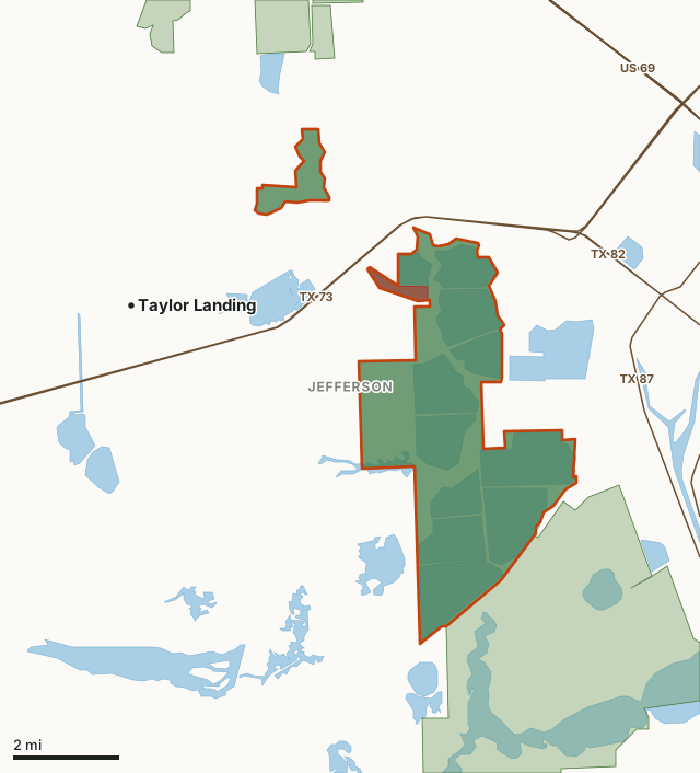
This areaOther public hunting landNo hunting zoneCounty lineLake or riverHighway
| TPWD unit | #783N and #783S |
|---|---|
| Size | 25,258 acres (TPWD booklet); 25,659 acres mapped |
| County | Jefferson County |
| Permit | Annual Public Hunting Permit ($48), eOSR registration each day |
| Legal game listed | Waterfowl, Early Teal, South Zone Duck, Geese, Rails, Gallinule, and Snipe and Feral Hog |
| Deer | No deer season for walk-in hunters in the booklet |
| Closed | Dates differ by unit; see each unit |
| White-tailed deer unit | TPWD unit 13 |
| Towns | Taylor Landing (3 mi), Nederland (6 mi) and Port Neches (6 mi) |
| Highways | TX 87, TX 73, TX 82 (0.6 mi) and US 287 (4.4 mi) |
Which units make up J.D. Murphree WMA?
TPWD prints J.D. Murphree WMA as 2 units in its 2026-27 booklet:
| Unit | Name | Acres (TPWD) | County | Legal game entries |
|---|---|---|---|---|
| #783N | J.D. Murphree WMA Big Hill Unit | 9,861 | Jefferson | 6 |
| #783S | J.D. Murphree WMA Salt Bayou Unit | 15,397 | Jefferson | 6 |
J.D. Murphree WMA, Big Hill Unit (#783N): what can you hunt in 2026-27?
J.D. Murphree WMA, Big Hill Unit is 9,861 acres in Jefferson County. TPWD's 2026-27 booklet lists 6 legal game entries for this unit, none of them deer. Every line below is TPWD's own wording.
| Species or season | What TPWD's 2026-27 booklet says |
|---|---|
| Waterfowl | Annual Public Hunt Permit ONLY. ALL Hunters must check in and out through the WMA check station and exit the WMA before noon. Check station opens at 4:30 AM. |
| Early Teal | Each day of the Early Teal season. Hunters must register at the WMA headquarters check station located on State Hwy. 73 |
| South Zone Duck | Only on Wednesday, Friday, Sunday, and January 30, no hunts will be held on Christmas Day or New Years Day. Hunters must register at the WMA headquarters check station located on State Hwy. 73. |
| Geese, Rails, Gallinule, and Snipe | May be taken during the seasons provided for these species during concurrent waterfowl hunts. |
| Feral Hog | Archery or Shotgun (slug or buckshot) only. Each day from Feb. 1- Apr. 30 (no bag limit). Shooting hours are one half hour before sunrise to one half hour after sunset. No registration required. Use of dogs allowed. No Baiting. |
| Fishing | Inside Compartments: Open Feb. 1- Aug 31. Closed Sept 1-Jan. 31. Big Hill Bayou and outside ditches: Sept. 1-Oct. 31 and Feb. 1-Aug. 31. Closed Nov. 1-Jan. 31. Fishing is restricted to one half hour before sunrise to one half hour after sunset. An APH or Limited Public Use (LPU) Permit is required to fish within the WMA unless all activity is confined to a boat within Big Hill Bayou, Taylor Bayou, Hillebrandt Bayou, and Blind Bayou. No commercial fishing/crabbing is allowed. No unattended lines. |
Youth and special seasons on J.D. Murphree WMA, Big Hill Unit
- Youth and Veteran/Active-Duty Military Only Waterfowl: See TPWD Outdoor Annual for Special Season information and regulations. Shooting hours end at noon.
- Youth/Adult Waterfowl: The First Saturday of each split of the South Zone Duck season and Dec. 26 and Jan. 2. All Hunts begin at 4:30 AM and end at noon. Each party must have at least one participating youth hunter and no more than two adults accompanying any single youth.
Rules on J.D. Murphree WMA, Big Hill Unit
- Permit and registration: OSR Required Each Day. MANDATORY eOSR: Hunters must complete on-site registration using the Texas Hunt and Fish app. and physically stop at the check station and mark their hunt locations on the area map. Waterfowl: Annual Public Hunt Permit ONLY.
- Closed: Access inside compartments is closed to all activities Sept. 1st-Jan. 31st, other than permitted hunters on designated hunt days and designated scouting days.
- Rule: MANDATORY eOSR: Hunters must complete on-site registration using the Texas Hunt and Fish app. and physically stop at the check station and mark their hunt locations on the area map.
- Notice: Access inside compartments is closed to all activities Sept. 1st-Jan. 31st, other than permitted hunters on designated hunt days and designated scouting days. Designated Scouting Days (the 7 days prior to the opener of the Youth Only South Zone Duck Season): Access to inside of compartments permitted for scouting purposes only. Scouting is restricted to one half hour before sunrise to one half hour after sunset.
- Special regulations: Trapping, use of horses, and water skiing is prohibited on the WMA. The use of airboats is prohibited, except in Big Hill Bayou and Blind Bayou. No more than 5 persons per hunt party.
- Note: Motorized access only on designated motorboat trails and named ditches. See checkstation map for “No Prop” zones and area closures. Motorboat operators are advised that disturbance of soils and plants on the WMA is prohibited. Entry to leveed compartments is permitted only at designated locations. “Jumping” levees is strictly prohibited.
Source: TPWD 2026-27 Map Booklet for Public Hunting Lands, unit #783N (PDF).
J.D. Murphree WMA, Salt Bayou Unit (#783S): what can you hunt in 2026-27?
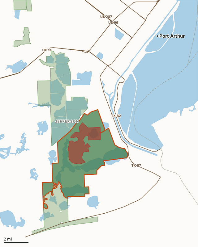
This areaOther public hunting landNo hunting zoneCounty lineLake or riverHighway
J.D. Murphree WMA, Salt Bayou Unit is 15,397 acres in Jefferson County. TPWD's 2026-27 booklet lists 6 legal game entries for this unit, none of them deer. Every line below is TPWD's own wording.
| Species or season | What TPWD's 2026-27 booklet says |
|---|---|
| Waterfowl | Annual Public Hunt Permit ONLY. ALL Hunters must check in and out through the WMA check station and exit the WMA before noon. Check station opens at 4:00 AM. |
| Early Teal | Each day of the Early Teal season. Hunters must register at the WMA headquarters check station located on State Hwy. 73. |
| South Zone Duck | Only on Saturday, Tuesday, Thursday, Nov. 27 and Jan. 31, no hunts will be held on Thanksgiving Day or Christmas Eve. Hunters must register at the WMA headquarters check station located on State Hwy. 73. |
| Geese, Rails, Gallinule, and Snipe | May be taken during the seasons provided for these species during concurrent waterfowl hunts. |
| Feral Hog | Archery or Shotgun (slug or buckshot) only. Feb. 1-Apr. 30 (no bag limit). Shooting hours are one half hour before sunrise to one half hour after sunset. Use of dogs allowed. No registration required. No Baiting. |
| Fishing | Inside Compartments: Open Feb. 1-Aug. 31 Closed Sept. 1-Jan 31. Fishing is restricted to one half hour before sunrise to one half hour after sunset. An APH or Limited Public Use (LPU) permit is required to fish within the WMA unless all activity is confined to a boat within Keith Lake, Johnson Lake, Shell Lake and Salt Lake. No commercial fishing/crabbing is allowed. No unattended lines. |
Youth and special seasons on J.D. Murphree WMA, Salt Bayou Unit
- Youth and Veteran/Active-Duty Military Only Waterfowl: See TPWD Outdoor Annual for Special Season information and regulations. Shooting hours end at noon.
- Youth/Adult Waterfowl: Dec. 23. All Hunts begin at 4:30 AM and end at noon. Each party must have at least one participating youth hunter and no more than two adults accompanying any single youth.
Rules on J.D. Murphree WMA, Salt Bayou Unit
- Permit and registration: OSR Required Each Day. MANDATORY eOSR: Hunters must complete on-site registration using the Texas Hunt and Fish app. and physically stop at the check station and mark their hunt locations on the area map. Waterfowl: Annual Public Hunt Permit ONLY.
- Closed: Access inside compartments is closed to all activities Sept. 1st-Jan. 31st, other than permitted hunters on designated hunt days and designated scouting days. Access to Horseshoe Trail is allowed year around for navigation purposes.
- Rule: MANDATORY eOSR: Hunters must complete on-site registration using the Texas Hunt and Fish app. and physically stop at the check station and mark their hunt locations on the area map.
- Notice: Access inside compartments is closed to all activities Sept. 1st-Jan. 31st, other than permitted hunters on designated hunt days and designated scouting days. Access to Horseshoe Trail is allowed year around for navigation purposes. Designated Scouting Days (the 7 days prior to the opener of the Youth Only South Zone Duck Season): Access to inside of compartments permitted for scouting purposes only. Scouting is restricted to one half hour before sunrise to one half hour after sunset.
- Special regulations: Trapping, use of horses, and water skiing is prohibited on the WMA. The use of airboats is prohibited, except in Keith Lake. No more than 5 persons per hunt party.
- Note: Motorized access only on designated motorboat trails and named ditches. See check station map for Designated Trails and area closures. Motorboat operators are advised that disturbance of soils and plants on the WMA is prohibited.
- Rule: Map legend: Limited Hunting (See check station map for details)
Source: TPWD 2026-27 Map Booklet for Public Hunting Lands, unit #783S (PDF).
Which parts of J.D. Murphree WMA are closed or limited?
TPWD's map of J.D. Murphree WMA marks no hunting zones and hunting compartments (open to hunting). No hunting zones are closed to all hunting. Hunting compartments are the numbered blocks hunters register for and hunt. Measured inside the boundary from TPWD's own polygons:
| Zone | Acres | Share of J.D. Murphree WMA |
|---|---|---|
| No hunting zones | 2,974 | 11.6% |
| Hunting compartments (open to hunting) | 19,410 | 75.6% |
Measured by FilledTag from TPWD's Public Hunt Locator map. Posted signs and the booklet's map are the final word on the ground.
How do you get to J.D. Murphree WMA?
J.D. Murphree WMA lies in Jefferson County. Nearest towns: Taylor Landing (3 miles), Nederland (6 miles), Port Neches (6 miles) and Port Arthur (7 miles). Highways within 5 miles: TX 87 (it crosses or touches the area), TX 73 (it crosses or touches the area), TX 82 (0.6 miles), US 287 (4.4 miles) and US 96 (4.4 miles). Water nearby: Shallow Prong Lake, Big Hill Reservoir and Johnson Lake.
TPWD's page says: Fishing, wildlife viewing and other non-consumptive uses are available seasonally as provided in the TPWD Public Hunting Lands Permit Map Booklet. These activities are limited during scheduled public hunts for September teal and regular waterfowl, feral hog and alligator seasons. A Limited Public Use permit is available for non-consumptive uses (e.g., bird watching, photography). An Annual Public Hunting permit is required for participating in public hunts. TPWD's page gives the area as 8,200 acres. Area office: (409) 736-2551, 10 Parks & Wildlife Dr., Port Arthur, TX 77640.
From TPWD's J.D. Murphree WMA page.
Which deer management unit is J.D. Murphree WMA in?
J.D. Murphree WMA lies in TPWD white-tailed deer management unit 13. TPWD publishes its harvest survey statewide; across Texas in 2025-26 it estimates 714,424 white-tailed deer hunters took 782,405 deer. The page on Texas public hunting has the statewide table.
Units: TPWD white-tailed deer management units. Harvest: TPWD Big Game Harvest Survey, 2025-26.
What other public hunting is near J.D. Murphree WMA?
The closest other places on the Annual Public Hunting Permit with a page of their own, measured edge to edge:
| Area | County | Distance |
|---|---|---|
| Sea Rim State Park | Jefferson | 2.9 mi |
| Lower Neches WMA | Orange | 10.2 mi |
| Tony Houseman WMA | Orange | 23.6 mi |
TPWD also leases 3 dove and small game areas within 40 miles, the nearest Bordages Road (1,272 acres, 1.3 mi), Latta Road (1,641 acres, 2.8 mi) and South China Road (1,036 acres, 15.8 mi). All of them are on the Texas dove leases page.
Questions hunters ask
Do you need a permit to hunt J.D. Murphree WMA?
Yes. Hunters 17 and older need the $48 Annual Public Hunting Permit along with a Texas hunting license; hunters under 17 may hunt free with a permitted adult. TPWD's booklet adds: OSR Required Each Day. MANDATORY eOSR: Hunters must complete on-site registration using the Texas Hunt and Fish app. and physically stop at the check station and mark their hunt locations on the area map. Waterfowl: Annual Public Hunt Permit ONLY.
Can you hunt deer on J.D. Murphree WMA?
Not on the Annual Public Hunting Permit: TPWD's 2026-27 booklet lists no deer season here.
Can you camp on J.D. Murphree WMA?
TPWD's 2026-27 booklet prints no camping rules for J.D. Murphree WMA. Ask the area office before planning to stay overnight.
Where is J.D. Murphree WMA?
J.D. Murphree WMA is in Jefferson County. The nearest towns: Taylor Landing (3 miles), Nederland (6 miles) and Port Neches (6 miles). Highways nearby: TX 87, TX 73 and TX 82.
Get a Texas hunt plan when they open
Hunt plans for Texas are coming. Join the list and you'll hear first. The first 50 hunters in each new state get their plan free.
Until then, the free FilledTag app for iPhone has a map that works in every state, Texas included.
Where these facts come from
- Legal game, dates, rules, permits and closures: TPWD 2026-27 Map Booklet for Public Hunting Lands, units #783N and #783S.
- Boundaries, zones and map points: TPWD Public Hunt Locator map. Acres and distances measured by FilledTag.
- Counties, highways and towns: U.S. Census Bureau TIGER/Line 2024 and Gazetteer. Lakes and rivers: USGS National Hydrography Dataset.
FilledTag is not part of the Texas Parks and Wildlife Department. TPWD's booklet and posted signs are the final word on every rule; nothing on this page is estimated by FilledTag.
Texas public hunting Jefferson County Sea Rim State Park Lower Neches WMA Tony Houseman WMA