Powderhorn WMA: access, drawn hunts and map
Powderhorn WMA is 15,093 acres in Calhoun County, owned or managed by TPWD. It has no page in TPWD's 2026-27 Map Booklet for Public Hunting Lands, so the Annual Public Hunting Permit alone does not open it to walk-in hunting. TPWD's page points hunters to drawn or special permit hunts. When it is open, in TPWD's words: The Powderhorn Wildlife Management Area (WMA) is open throughout the year for limited public use including scheduled bird watching and public hunting activities. To enter the WMA, visitors do not need a permit for bird watching; but hunters must have a Special Permit for Powderhorn Drawn Hunts. See the Powderhorn WMA aerial map for location information.
Data updated October 2026. Area facts: TPWD's page for Powderhorn WMA. Boundary: TPWD's WMA layer.
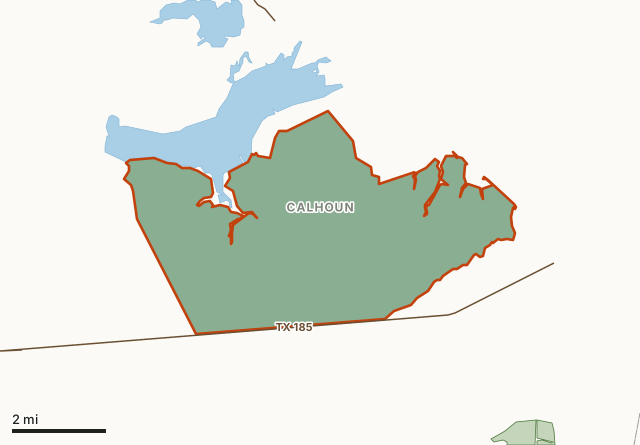
This areaOther public hunting landCounty lineLake or riverHighway
| Size | 15,093 acres (TPWD); 15,060 acres mapped |
|---|---|
| County | Calhoun County |
| Walk-in hunting on the APH permit | No booklet page for 2026-27 |
| When it is open | The Powderhorn Wildlife Management Area (WMA) is open throughout the year for limited public use including scheduled bird watching and public hunting activities. To enter the WMA, visitors do not need |
| Area office | (361) 205-1510 |
| Towns | Port Lavaca (11 mi), Seadrift (11 mi) and Point Comfort (13 mi) |
| Highways | TX 185 and TX 316 (2.2 mi) |
What is Powderhorn WMA for?
The Powderhorn Wildlife Management Area (WMA) is located in southern Calhoun County near Port O'Conner in the Texas Coastal Bend. The WMA consists of 15,093 acres of freshwater and brackish wetlands, coastal tallgrass prairie and mottes, rounded shrubby, stands of coastal live oak trees. Several miles of bayfront land on both Powderhorn Lake and Matagorda Bay make up the north and east boundaries of the WMA.
The Powderhorn property was purchased with funding and support from the BP Horizon oil spill mitigation, Texas Parks and Wildlife Foundation, The Nature Conservancy, The Conservation Fund, National Fish and Wildlife Foundation and many private donations. In October 2018, the property was donated to Texas Parks and Wildlife Department and became the Powderhorn WMA.
The habitat in this area was historically considered to be coastal prairie with vast grasslands and scattered mottes of large coastal live oaks. But land management practices of overgrazing and suppression of wildfires have resulted in a monoculture of running oak. Starting in 2015, we began to restore the prairie using herbicide treatment and prescribed fire. The result of these conservation efforts is about 7,200 acres have been converted back to native coastal prairie on Powderhorn WMA. Conservation efforts will continue to restore more of the habitat on the WMA.
From TPWD's Powderhorn WMA page.
Can you hunt Powderhorn WMA?
Only through TPWD's drawn or special permit hunts, by TPWD's page: To enter the WMA, visitors do not need a permit for bird watching; but hunters must have a Special Permit for Powderhorn Drawn Hunts. Powderhorn WMA has no page in the 2026-27 Map Booklet for Public Hunting Lands, so the Annual Public Hunting Permit alone does not open it.
TPWD's drawn hunts are listed in its Public Hunt Drawing System, by area and hunt category.
How do you get to Powderhorn WMA?
Powderhorn WMA lies in Calhoun County. Nearest towns: Port Lavaca (11 miles), Seadrift (11 miles), Point Comfort (13 miles) and Austwell (18 miles). Highways within 5 miles: TX 185 (it crosses or touches the area) and TX 316 (2.2 miles). Water nearby: Powderhorn Lake.
Where can you hunt near Powderhorn WMA?
The closest places on the Annual Public Hunting Permit with a page of their own:
| Area | County | Distance |
|---|---|---|
| Matagorda Island WMA | Calhoun | 3.3 mi |
| Guadalupe Delta WMA | Calhoun and Refugio | 14.3 mi |
| Mad Island WMA | Matagorda | 24 mi |
| Nannie M. Stringfellow WMA | Brazoria | 56.4 mi |
Questions hunters ask
Can you hunt Powderhorn WMA?
Only through TPWD's drawn or special permit hunts, by TPWD's page: To enter the WMA, visitors do not need a permit for bird watching; but hunters must have a Special Permit for Powderhorn Drawn Hunts. Powderhorn WMA has no page in the 2026-27 Map Booklet for Public Hunting Lands, so the Annual Public Hunting Permit alone does not open it.
How big is Powderhorn WMA?
TPWD gives it as 15,093 acres; FilledTag measures 15,060 acres inside TPWD's WMA boundary.
Where is Powderhorn WMA?
In Calhoun County. Nearest towns: Port Lavaca (11 miles), Seadrift (11 miles) and Point Comfort (13 miles). TPWD's address for the area: 10769 FM 1289, Port O'Connor, TX 77982.
Where is the nearest walk-in public hunting to Powderhorn WMA?
Matagorda Island WMA, 3.3 mi away, on the Annual Public Hunting Permit.
Get a Texas hunt plan when they open
Hunt plans for Texas are coming. Join the list and you'll hear first. The first 50 hunters in each new state get their plan free.
Until then, the free FilledTag app for iPhone has a map that works in every state, Texas included.
Where these facts come from
- Area description, hours and contact: TPWD, Powderhorn WMA.
- Boundary: TPWD WMA boundaries. Nearby public hunting: TPWD Public Hunt Locator map and TPWD 2026-27 Map Booklet.
- Counties, highways and towns: U.S. Census Bureau TIGER/Line 2024 and Gazetteer.
FilledTag is not part of the Texas Parks and Wildlife Department.