Wildcat WMA: hunting, access and rules
Wildcat WMA is a 6,809-acre wildlife management area owned by the Utah Division of Wildlife Resources in Wasatch County, in DWR's Northeastern Region, managed for big game habitat. DWR's seasonal closure: Road closed one day a year sometime in January. Within 3 miles of it, 27.8% of the land is public, mostly DWR wildlife land.
Data updated October 2026. Property facts: DWR's public access properties layer. Units: DWR's 2026 boundaries. Land around it: UGRC, 2023.
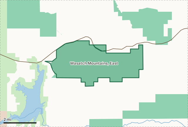
National forestDWR wildlife landTribal land (tribe's rules)Wildcat WMAGeneral-season deer unit lineLake or riverHighway
| Size | 6,809 acres (DWR) |
|---|---|
| County | Wasatch |
| DWR region | Northeastern Region |
| Managed for | Big game habitat |
| Seasonal closure | Road closed one day a year sometime in January |
| Access | Legal Access, Public Access |
| DWR property since | 1988 |
| Nearest towns | Tabiona (15 mi), Independence (21 mi) and Wallsburg (25 mi) |
| A point inside it | 40.1815, -110.9639 (latitude, longitude) |
What are the rules on Wildcat WMA?
Seasonal closure: Road closed one day a year sometime in January. Motorized vehicle use is restricted to existing roads. DWR lists no license or digital access permit requirement for this WMA yet.
DWR runs Wildcat under its habitat management plan of 1998.
What is allowed where on a WMA: DWR's WMA map.
Which hunt units is Wildcat WMA in?
Wildcat WMA lies in 3 units with a page of their own; on the Wasatch Mountains, East general-season deer unit as a whole, hunters took 1,658 bucks in 2025 (DWR):
| Unit | Hunt type | Share of the WMA in it |
|---|---|---|
| Wasatch Mountains, East | general-season deer | 100% |
| Wasatch Mountains | limited-entry bull elk | 100% |
| Wasatch Mountains/Central Mountains | once-in-a-lifetime bull moose | 100% |
Shares measured by FilledTag from DWR's 2026 unit boundaries and the WMA boundary. Harvest: DWR harvest reports, 2013 to 2025; each unit's page has it year by year.
What wildlife does DWR list for Wildcat WMA?
Sagebrush, mountainbrush, riparian, meadow, elk, deer, sage grouse.
DWR's own words for the property's primary habitat and species.
What land surrounds Wildcat WMA?
Within 3 miles of the WMA's boundary, 27.8% of the land is public land open to hunting, most of it DWR wildlife land (8,117 acres).
| Manager | Acres | Share of the 3-mile ring |
|---|---|---|
| DWR wildlife land | 8,117 | 17% |
| National forest | 5,141 | 10.8% |
| Private and other land not shown | 34,418 | 72.2% |
Measured by FilledTag from UGRC's statewide land ownership map (last edited 2023).
What other WMAs are near Wildcat WMA?
DWR's other wildlife management areas within 25 miles, as the crow flies from center to center: Currant Creek WMA (14,977 acres, 4 miles northeast), Strawberry River WMA (22,929 acres, 5 miles south), Tabby Mountain WMA (50,226 acres, 13 miles northeast), Horse Ridge WMA (14,283 acres, 16 miles south), Rabbit Gulch WMA (9,198 acres, 21 miles east) and Lake Canyon WMA (7,586 acres, 21 miles southeast).
How do you get to Wildcat WMA?
Highways within 8 miles: US 40. Nearest towns: Tabiona (15 miles), Independence (21 miles), Wallsburg (25 miles) and Duchesne (27 miles). DWR also lists it under the older names Current Creek WMA, Fitzgerald.
Questions hunters ask
When is Wildcat WMA closed?
Road closed one day a year sometime in January, by DWR's listing for the area. Motorized vehicle use is restricted to existing roads.
Do you need a permit to enter Wildcat WMA?
DWR lists no license or digital access permit requirement for this WMA yet, by DWR's 2026 listing for Wasatch County.
How much public land is around Wildcat WMA?
27.8% of the land within 3 miles of the WMA is public land open to hunting, most of it DWR wildlife land (8,117 acres), measured from UGRC's land ownership map.
Which deer and elk units is Wildcat WMA in?
The Wasatch Mountains, East general-season deer unit and the Wasatch Mountains limited-entry elk unit, by DWR's 2026 boundaries. Hunting on the WMA follows that unit's seasons and DWR's rules for the property.
Get a Utah hunt plan when they open
Hunt plans for Utah are coming. Join the list and you'll hear first. The first 50 hunters in each new state get their plan free.
Until then, the free FilledTag app for iPhone has a map that works in every state, Utah included.
Sources: DWR property data, DWR's WMA page, DWR unit boundaries, UGRC's statewide land ownership map (last edited 2023). FilledTag is not part of DWR.