Northeastern Region: Utah hunting units, public land and WMAs
DWR's Northeastern Region, run from the Vernal office, covers 9,201 square miles of Utah and is 61.9% public land, measured from UGRC's land ownership map. Its 3 general-season deer units gave up 2,836 bucks in 2025, and its 4 limited-entry elk units 161 bulls in 2025, by DWR's harvest reports.
Data updated October 2026. Harvest: DWR's reports to 2025. Land: UGRC, 2023. WMAs: DWR's public access properties.
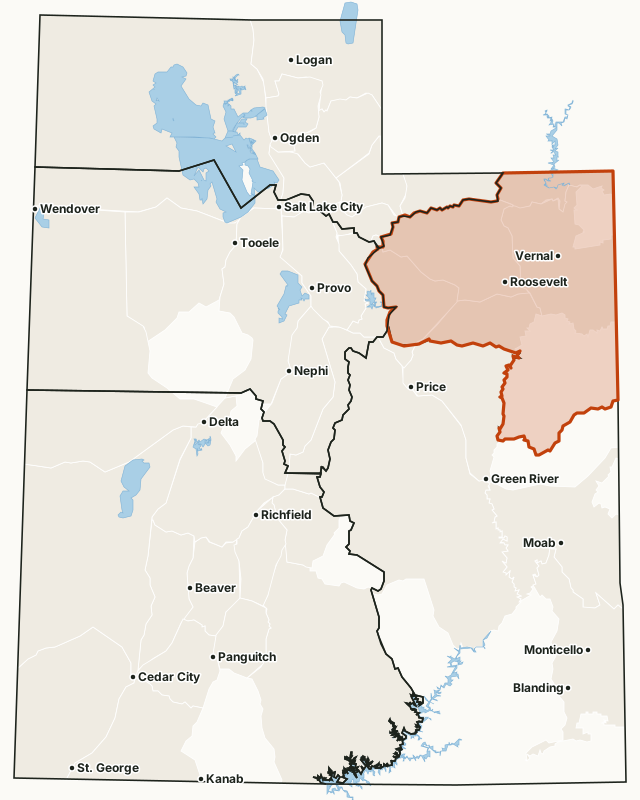
Which hunt units are in the Northeastern Region?
Every unit below lies mostly in the Northeastern Region by DWR's region map, with DWR's latest harvest and the public land share measured inside it. Utah draws a separate map of units for each species and hunt type, so the same ground appears under several units.
General-season deer units
| Unit | Square miles | Public land | Bucks harvested (DWR) | Hunters afield |
|---|---|---|---|---|
| Wasatch Mountains, East | 1,631 | 54.2% | 1,658 (2025) | 4,573 |
| Vernal/Bonanza | 2,062 | 72.8% | 634 (2025) | 1,009 |
| Yellowstone | 1,947 | 49.8% | 544 (2025) | 1,032 |
Limited-entry deer units
| Unit | Square miles | Public land | Bucks harvested (DWR) | Permits |
|---|---|---|---|---|
| Book Cliffs, North | 2,288 | 60.1% | 117 (2025) | 128 |
| Diamond Mountain | 416 | 67.9% | 107 (2025) | 115 |
| Book Cliffs | 3,579 | 72.9% | 96 (2025) | 112 |
Limited-entry bull elk units
| Unit | Square miles | Public land | Bulls harvested (DWR) | Permits |
|---|---|---|---|---|
| Diamond Mountain | 416 | 67.9% | 66 (2025) | 109 |
| Book Cliffs, Bitter Creek/East | 3,052 | 69.3% | 62 (2025) | 97 |
| North Slope, Three Corners | 225 | 95% | 23 (2025) | 30 |
| Book Cliffs, Little Creek Roadless | 89 | 99.9% | 10 (2025) | 11 |
Limited-entry buck pronghorn units
| Unit | Square miles | Public land | Bucks harvested (DWR) | Permits |
|---|---|---|---|---|
| Nine Mile, Anthro-Myton Bench | 1,027 | 65.6% | 135 (2025) | 168 |
| Vernal | 1,252 | 66.5% | 67 (2025) | 113 |
| Book Cliffs, Bitter Creek | 2,199 | 58.5% | 60 (2025) | 72 |
| North Slope, Three Corners/West Daggett | 618 | 89.1% | 52 (2025) | 66 |
Once-in-a-lifetime bull moose units
| Unit | Square miles | Public land | Moose harvested (DWR) | Permits |
|---|---|---|---|---|
| North Slope, Three Corners/West Daggett | 618 | 89.1% | 8 (2025) | 8 |
| Yellowstone | 1,947 | 49.8% | 5 (2025) | 5 |
| Diamond Mountain/Vernal | 1,668 | 66.9% | 1 (2025) | 2 |
Once-in-a-lifetime Rocky Mountain bighorn sheep units
| Unit | Square miles | Public land | Sheep harvested (DWR) | Permits |
|---|---|---|---|---|
| Nine Mile, Jack Creek | 3,468 | 56% | 4 (2025) | 4 |
| North Slope, Three Corners | 225 | 95% | 3 (2025) | 3 |
Once-in-a-lifetime mountain goat units
| Unit | Square miles | Public land | Goats harvested (DWR) | Permits |
|---|---|---|---|---|
| High Uintas West | 673 | 99.2% | 10 (2025) | 12 |
| High Uintas Central | 465 | 99.6% | 4 (2025) | 5 |
| High Uintas East | 497 | 99.8% | 3 (2025) | 3 |
| High Uintas Leidy Peak | 474 | 98.7% | 1 (2025) | 1 |
Once-in-a-lifetime bison units
| Unit | Square miles | Public land | Bison harvested (DWR) | Permits |
|---|---|---|---|---|
| Book Cliffs, Bitter Creek | 2,199 | 58.5% | 14 (2025) | 17 |
Harvest: DWR harvest reports, 2013 to 2025. Public land measured by FilledTag from UGRC's statewide land ownership map (last edited 2023). Region: DWR regional boundaries.
How much of the Northeastern Region is public land?
61.9% of the region is public land open to hunting, the largest share BLM (1,596,865 acres). 1,063,212 acres are tribal land.
| Manager | Acres | Share of the Northeastern Region |
|---|---|---|
| BLM | 1,596,865 | 27.1% |
| National forest | 1,430,008 | 24.3% |
| Tribal land (tribe's rules) | 1,063,212 | 18.1% |
| State trust land (SITLA) | 441,805 | 7.5% |
| DWR wildlife land | 167,053 | 2.8% |
| National park or monument (NPS, no hunting) | 52,990 | 0.9% |
| State park (park rules) | 11,762 | 0.2% |
| State sovereign land (lake and river beds) | 9,374 | 0.2% |
| National wildlife refuge | 7,884 | 0.1% |
| Bureau of Reclamation | 739 | under 0.1% |
| Other public land (highways, other state land) | 79 | under 0.1% |
| Private and other land not shown | 1,106,578 | 18.8% |
What wildlife management areas are in the Northeastern Region?
DWR lists 26 wildlife and waterfowl management areas in the region, from Book Cliffs Roadless WMA (56,694 acres) down to Bare Top Mountain WMA (120 acres). 20 of them have a page here.
- Book Cliffs Roadless WMA: 56,694 acres
- Tabby Mountain WMA: 50,226 acres
- Strawberry River WMA: 22,929 acres
- Currant Creek WMA: 14,977 acres
- Horse Ridge WMA: 14,283 acres
- Two Waters WMA: 10,897 acres
- Mail Draw WMA: 9,990 acres
- Rabbit Gulch WMA: 9,198 acres
- Lake Canyon WMA: 7,586 acres
- Wildcat WMA: 6,809 acres
- Cottonwood Ridge WMA: 6,751 acres
- Skitzy WMA: 5,198 acres
- Willow Creek (Uintah/Grand) WMA: 3,748 acres
- Marshall Draw WMA: 3,333 acres
- Browns Park WMA: 3,132 acres
- Red Creek WMA: 2,416 acres
- Bitter Creek WMA: 2,194 acres
- Cook WMA: 1,647 acres
- Goslin Mountain WMA: 1,199 acres
- Little Hole WMA: 1,139 acres
- Stewart Lake WMA: 684 acres
- Taylor Flat WMA: 479 acres
- Kevin Conway WMA: 268 acres
- Little Montes Creek WMA: 193 acres
- Trail Creek WMA: 159 acres
- Bare Top Mountain WMA: 120 acres
DWR's Walk-In Access program has 1 active hunting property in the region, about 238 acres of private land open to walk-in hunting under each property's rules (DWR Walk-In Access).
Get a Utah hunt plan when they open
Hunt plans for Utah are coming. Join the list and you'll hear first. The first 50 hunters in each new state get their plan free.
Until then, the free FilledTag app for iPhone has a map that works in every state, Utah included.
Sources: DWR harvest reports, 2013 to 2025; UGRC's statewide land ownership map (last edited 2023); DWR public access properties (WMAs); DWR Walk-In Access properties (December 17, 2025); DWR regional boundaries. FilledTag is not part of the Utah Division of Wildlife Resources.
Utah hunting units Northern Region Central Region Southeastern Region Southern Region