High Uintas Leidy Peak mountain goat unit: draw, harvest and public land
High Uintas Leidy Peak is a 474-square-mile once-in-a-lifetime mountain goat unit in DWR's Northeastern Region of Utah. Once-in-a-lifetime mountain goat hunters here took 1 goat on 1 permit in 2025, by DWR's 2025 harvest report (preliminary). The unit is 98.7% public land open to hunting, most of it national forest (299,371 acres), measured from UGRC's statewide land ownership map (last edited 2023).
Data updated October 2026. Seasons: DWR's 2026 guidebook. Harvest: DWR's reports, 2013 to 2025. Draw: DWR's 2024 and 2025 results. Land: UGRC, 2023.
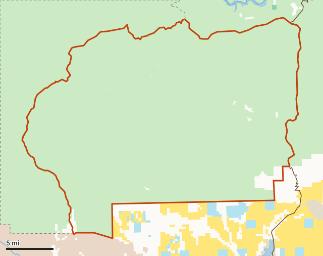
National forestBLMState trust land (SITLA)DWR wildlife landTribal land (tribe's rules)State park (park rules)High Uintas Leidy PeakNeighboring mountain goat unitsLake or riverHighway
| DWR region | Northeastern Region (Vernal office) |
|---|---|
| Size | 303,417 acres (474 square miles) |
| Public land | 98.7% (299,417 acres) |
| 2026 hunts on this unit | 1 (DWR guidebook) |
| Goats harvested, 2025 | 1 on 1 permit |
| Harvest per 100 hunters, 2025 | 100 (from DWR's figures) |
| 2025 first-choice applicants | 126 residents, 0 nonresidents (1 drew) |
| Towns in and near it | Dutch John, Manila and Vernal |
When are the 2026 mountain goat hunts on High Uintas Leidy Peak?
DWR's 2026 guidebook lists 1 once-in-a-lifetime mountain goat hunt on this unit, shown here with the 2025 draw for the same hunt number where DWR used it.
| Hunt number | Hunt | 2026 season | 2025 first-choice applicants (residents) | 2025 permits drawn (residents) | 2025 first-choice applicants (nonresidents) | 2025 permits drawn (nonresidents) |
|---|---|---|---|---|---|---|
| GO6807 | Rifle (any legal weapon) | Sept. 5-Oct. 31 | 126 | 1 |
Source: 2026 Utah Big Game Application Guidebook, hunt tables, page 68; boundaries from DWR Hunt Planner hunt table. DWR can change a season during the year: check the Utah Hunt Planner before you go.
How many goats are taken on High Uintas Leidy Peak each year?
DWR's harvest reports cover High Uintas Leidy Peak's once-in-a-lifetime mountain goat hunts in 13 years from 2013 to 2025. In 2025, 1 hunter afield took 1 goat, 100 for every 100 hunters. In 2024: 1 from 1 hunter on 1 permit.
| Year | Hunt | Permits | Hunters afield | Goats harvested | DWR's percent success | Average days | Satisfaction (1 to 5) |
|---|---|---|---|---|---|---|---|
| 2025 | GO6807 | 1 | 1 | 1 | 100% | 6 | 5 |
| 2024 | GO6807 | 1 | 1 | 1 | 100% | 2 | 5 |
| 2023 | GO6807 | 2 | 2 | 1 | 50% | 6.5 | 3 |
| 2022 | GO6807 | 2 | 2 | 2 | 100% | 10 | 4 |
| 2021 | GO6807 | 3 | 3 | 3 | 100% | 3 | 5 |
| 2020 | GO6807 | 3 | 3 | 3 | 100% | 6 | 3.7 |
| 2019 | GO6807 | 3 | 3 | 3 | 100% | 4.7 | 4.7 |
| 2018 | GO6807 | 3 | 3 | 1 | 33.3% | 9.3 | 3.7 |
| 2017 | GO6807 | 2 | 2 | 1 | 50% | 4.5 | 4.5 |
| 2016 | GO6807 | 2 | 2 | 2 | 100% | 8.5 | 4.5 |
| 2015 | GO6807 | 2 | 2 | 2 | 100% | 1 | 5 |
| 2014 | GO6807 | 3 | 3 | 3 | 100% | 6.3 | |
| 2013 | GO6807 | 2 | 2 | 2 | 100% | 1.5 |
Source: DWR harvest reports, 2013 to 2025, every once-in-a-lifetime mountain goat hunt DWR printed for this unit's name each year. CWMU, landowner, conservation and sportsman permits are not included. Harvest per 100 hunters is worked out from DWR's own two numbers.
Each 2025 hunt on High Uintas Leidy Peak
| Hunt | Weapon | Permits | Hunters afield | Goats harvested | DWR's percent success | Average days | Satisfaction (1 to 5) |
|---|---|---|---|---|---|---|---|
| GO6807 | Rifle (any legal weapon) | 1 | 1 | 1 | 100% | 6 | 5 |
Source: DWR 2025 harvest report (preliminary).
High Uintas Leidy Peak by weapon, year by year
Goats harvested of permits issued, by weapon, for each year DWR reported since 2018:
| Weapon | 2025 | 2024 | 2023 | 2022 | 2021 | 2020 | 2019 | 2018 |
|---|---|---|---|---|---|---|---|---|
| Rifle (any legal weapon) | 1 of 1 | 1 of 1 | 1 of 2 | 2 of 2 | 3 of 3 | 3 of 3 | 3 of 3 | 1 of 3 |
Source: DWR harvest reports, 2018 to 2025. An empty cell means DWR printed no hunt of that kind on this unit that year.
How many hunters apply for High Uintas Leidy Peak mountain goat permits?
In DWR's 2025 draw, 126 residents put a High Uintas Leidy Peak mountain goat hunt first and 1 drew a permit, 0.8% of them; no nonresident applied first choice. In 2024, 129 residents applied first choice and 1 drew. Limited-entry and once-in-a-lifetime permits are drawn on bonus points: DWR reserves half of each hunt's permits for the applicants with the most points and draws the rest at random (Utah Admin. Rule R657-62-8).
| Hunt | DWR's hunt name | Resident applicants | Residents drawn | Nonresident applicants | Nonresidents drawn |
|---|---|---|---|---|---|
| GO6807 | Mountain goat | 126 | 1 |
| Hunt | Residents, reserved permits: points | Residents, random permits: points | Nonresidents, reserved permits: points | Nonresidents, random permits: points |
|---|---|---|---|---|
| GO6807 | 7 |
From DWR's 2025 drawing results, which list each point level's permits from the reserved half (most points first) and from the random half. A blank cell means no permit of that kind went to the group.
| Hunt | DWR's hunt name | Resident applicants | Residents drawn | Nonresident applicants | Nonresidents drawn |
|---|---|---|---|---|---|
| GO6807 | Mountain goat | 129 | 1 |
Source: DWR 2025 drawing results and DWR 2024 drawing results, first-choice applications only, as DWR reports them; DWR leaves out second to fifth choices. The share who drew in a past year is not a forecast for the next draw. Deadlines and fees: Utah draw deadlines and fees.
How much of High Uintas Leidy Peak is public land?
98.7% of the High Uintas Leidy Peak mountain goat unit is public land open to hunting under its manager's rules: 299,417 of 303,417 acres. The largest share is national forest, 299,371 acres or 98.7% of the unit. 30 acres are tribal land, hunted only under the tribe's own rules.
| Manager | Acres | Share of High Uintas Leidy Peak |
|---|---|---|
| National forest | 299,371 | 98.7% |
| BLM | 31 | under 0.1% |
| Tribal land (tribe's rules) | 30 | under 0.1% |
| State trust land (SITLA) | 15 | under 0.1% |
| Private and other land not shown | 3,970 | 1.3% |
Measured by FilledTag inside DWR's 2026 boundary from UGRC's statewide land ownership map (last edited 2023). State trust land (SITLA) is open to hunting where it can be reached legally; many sections touch no public road. A permit does not allow hunting on CWMUs, tribal land or national parks.
What other hunts share the High Uintas Leidy Peak mountain goat unit's ground?
Utah draws a separate map of units for each species and hunt type. These units cover part of the same ground, measured from DWR's 2026 boundaries:
| Unit | Hunt type | Share of High Uintas Leidy Peak it covers |
|---|---|---|
| Vernal/Bonanza | general-season deer | 78% |
| Vernal/Bonanza | general-season any bull elk (over the counter) | 78% |
| Diamond Mountain/Vernal | once-in-a-lifetime bull moose | 78% |
| Vernal | limited-entry buck pronghorn | 78% |
| North Slope, West Daggett | general-season any bull elk (over the counter) | 22% |
| North Slope, Three Corners/West Daggett | once-in-a-lifetime bull moose | 22% |
| North Slope, Three Corners/West Daggett | limited-entry buck pronghorn | 22% |
| North Slope, Summit/West Daggett | once-in-a-lifetime Rocky Mountain bighorn sheep | 22% |
| North Slope | general-season deer | 22% |
How do you get to the High Uintas Leidy Peak unit?
Highways through the unit: US 191 (about 7 miles inside it). Nearby: Dutch John (6 miles), Manila (8 miles), Vernal (10 miles) and Naples (11 miles).
Which mountain goat units border or overlap High Uintas Leidy Peak?
| Unit | Square miles | Public land | Goats harvested (DWR) |
|---|---|---|---|
| High Uintas East | 497 | 99.8% | 3 (2025) |
Questions hunters ask
When are the 2026 mountain goat hunts on High Uintas Leidy Peak?
DWR's 2026 guidebook lists 1 once-in-a-lifetime mountain goat hunt on High Uintas Leidy Peak: Rifle (any legal weapon) Sept. 5-Oct. 31 (GO6807).
How many goats were harvested on High Uintas Leidy Peak in 2025?
1, by DWR's 2025 harvest report (preliminary): 1 hunter afield on 1 permit, 100 goats for every 100 hunters. In 2024 the count was 1.
How many people apply for High Uintas Leidy Peak mountain goat permits?
126 residents and 0 nonresidents made a High Uintas Leidy Peak hunt their first choice in DWR's 2025 draw; 1 resident and 0 nonresidents drew (DWR 2025 drawing results).
Is High Uintas Leidy Peak mostly public land?
Yes. 98.7% of the unit is public land open to hunting, most of it national forest (299,371 acres), measured from UGRC's land ownership map.
What is the closest town to the High Uintas Leidy Peak mountain goat unit?
No town is inside it. The nearest: Dutch John (6 miles), Manila (8 miles) and Vernal (10 miles).
DWR's boundary description for High Uintas Leidy Peak
Duchesne, Summit, and Uintah counties: Boundary begins where the Whiterocks River crosses the USFS boundary; north along the Whiterocks River to Whiterocks Lake and USFS Trail 025; east on this trail to USFS Trail 019; north on this trail over an unnamed pass to Weyman Park and Weyman Creek; northeast along Weyman Creek to Brownie Lake and Carter Creek; east along this creek to SR-44; east on SR-44 to SR-191; south on this road to the USFS boundary; west along this boundary to the Whiterocks River. USGS 1:100,000 Maps: Dutch John. Boundary questions? Call the Vernal office, 435-781-9459.
From DWR's 2026 unit layer.
Get a Utah hunt plan when they open
Hunt plans for Utah are coming. Join the list and you'll hear first. The first 50 hunters in each new state get their plan free.
Until then, the free FilledTag app for iPhone has a map that works in every state, Utah included.
Where these numbers come from
- Harvest, permits, hunters, days and satisfaction: DWR harvest reports, 2013 to 2025 (2025 preliminary).
- 2026 hunts and season dates: 2026 Utah Big Game Application Guidebook; boundary names: DWR Hunt Planner hunt table.
- Applicants and permits drawn: DWR drawing results, 2024 and 2025.
- Unit boundary: DWR 2026 hunt unit boundaries. Public land: UGRC's statewide land ownership map (last edited 2023). WMAs: DWR public access properties (WMAs). Walk-In Access: DWR Walk-In Access properties (December 17, 2025).
- Highways and towns: U.S. Census Bureau TIGER/Line 2024 primary and secondary roads; U.S. Census Bureau 2024 Gazetteer, places.
FilledTag is not part of the Utah Division of Wildlife Resources. Numbers are copied from DWR and the State of Utah, or measured from their maps; nothing on this page is estimated by FilledTag.
Utah hunting units Northeastern Region Utah draw deadlines High Uintas East