Central Region: Utah hunting units, public land and WMAs
DWR's Central Region, run from the Springville office, covers 15,328 square miles of Utah and is 54.9% public land, measured from UGRC's land ownership map. Its 2 general-season deer units gave up 2,592 bucks in 2025, and its 3 limited-entry elk units 500 bulls in 2025, by DWR's harvest reports.
Data updated October 2026. Harvest: DWR's reports to 2025. Land: UGRC, 2023. WMAs: DWR's public access properties.
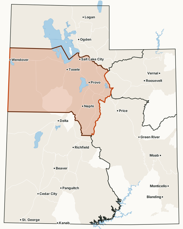
Which hunt units are in the Central Region?
Every unit below lies mostly in the Central Region by DWR's region map, with DWR's latest harvest and the public land share measured inside it. Utah draws a separate map of units for each species and hunt type, so the same ground appears under several units.
General-season deer units
| Unit | Square miles | Public land | Bucks harvested (DWR) | Hunters afield |
|---|---|---|---|---|
| Nebo | 1,472 | 49.1% | 1,417 (2025) | 3,834 |
| Wasatch Mountains, West | 1,220 | 59% | 1,175 (2025) | 4,775 |
Limited-entry deer units
| Unit | Square miles | Public land | Bucks harvested (DWR) | Permits |
|---|---|---|---|---|
| West Desert, Vernon | 1,521 | 89.4% | 209 (2025) | 264 |
Limited-entry bull elk units
| Unit | Square miles | Public land | Bulls harvested (DWR) | Permits |
|---|---|---|---|---|
| Wasatch Mountains | 2,568 | 57.6% | 417 (2025) | 740 |
| Nebo/San Pitch Mountains | 965 | 50.9% | 64 (2025) | 103 |
| West Desert, Deep Creek | 656 | 84.5% | 19 (2025) | 27 |
Limited-entry buck pronghorn units
| Unit | Square miles | Public land | Bucks harvested (DWR) | Permits |
|---|---|---|---|---|
| West Desert, Snake Valley | 5,564 | 68% | 94 (2025) | 123 |
| West Desert, Riverbed | 3,665 | 72% | 91 (2025) | 96 |
| West Desert, Rush Valley | 2,833 | 37.7% | 42 (2025) | 46 |
| Box Elder, Puddle Valley | 452 | 87.4% | 17 (2025) | 21 |
Once-in-a-lifetime bull moose units
| Unit | Square miles | Public land | Moose harvested (DWR) | Permits |
|---|---|---|---|---|
| Wasatch Mountains/Central Mountains | 6,884 | 61.2% | 20 (2025) | 23 |
Once-in-a-lifetime Rocky Mountain bighorn sheep units
| Unit | Square miles | Public land | Sheep harvested (DWR) | Permits |
|---|---|---|---|---|
| Box Elder, Newfoundland Mountain | 1,804 | 55% | 11 (2025) | 12 |
| Oquirrh-Stansbury, West | 751 | 51.9% | 3 (2025) | 3 |
| Nebo | 1,472 | 49.1% | 2 (2025) | 2 |
| Wasatch Mountains, West | 1,220 | 59% | 1 (2025) | 2 |
Once-in-a-lifetime mountain goat units
| Unit | Square miles | Public land | Goats harvested (DWR) | Permits |
|---|---|---|---|---|
| Nebo | 1,472 | 49.1% | 27 (2025) | 31 |
| Wasatch Mountains, Timpanogos | 97 | 56.3% | 9 (2025) | 11 |
| Wasatch Mountains, Provo Peak | 213 | 62.6% | 5 (2025) | 5 |
| Wasatch Mountains, Box Elder Peak | 79 | 59.9% | 3 (2025) | 3 |
| Wasatch Mountains, Lone Peak | 240 | 51.6% | 1 (2025) | 1 |
Harvest: DWR harvest reports, 2013 to 2025. Public land measured by FilledTag from UGRC's statewide land ownership map (last edited 2023). Region: DWR regional boundaries.
How much of the Central Region is public land?
54.9% of the region is public land open to hunting, the largest share BLM (3,516,724 acres). 69,944 acres are tribal land. 1,600,181 acres are military land, closed to the public.
| Manager | Acres | Share of the Central Region |
|---|---|---|
| BLM | 3,516,724 | 35.8% |
| Military land (closed) | 1,600,181 | 16.3% |
| National forest | 1,270,975 | 13% |
| State trust land (SITLA) | 456,998 | 4.7% |
| State sovereign land (lake and river beds) | 362,732 | 3.7% |
| DWR wildlife land | 112,747 | 1.1% |
| Tribal land (tribe's rules) | 69,944 | 0.7% |
| State park (park rules) | 33,966 | 0.3% |
| National wildlife refuge | 17,962 | 0.2% |
| Bureau of Reclamation | 5,749 | 0.1% |
| Other public land (highways, other state land) | 2,174 | under 0.1% |
| National park or monument (NPS, no hunting) | 254 | under 0.1% |
| Private and other land not shown | 2,359,788 | 24.1% |
What wildlife management areas are in the Central Region?
DWR lists 48 wildlife and waterfowl management areas in the region, from Wallsburg WMA (13,602 acres) down to Rock Island WMA (2 acres). 26 of them have a page here.
- Wallsburg WMA: 13,602 acres
- Loafer Mountain WMA: 12,355 acres
- Twelve Mile WMA: 9,150 acres
- Starvation WMA: 8,022 acres
- Spencer Fork WMA: 7,488 acres
- Dairy Fork WMA: 4,953 acres
- Santaquin WMA: 4,851 acres
- North Hollow WMA: 3,601 acres
- Lasson Draw WMA: 2,881 acres
- Triangle Ranch WMA: 2,840 acres
- Six Mile WMA: 2,782 acres
- Lake Fork WMA: 2,765 acres
- Bald Mountain WMA: 2,562 acres
- Manti Face WMA: 2,536 acres
- Nine Mile WMA: 2,500 acres
- Timpanogos WMA: 2,364 acres
- Levan WMA: 2,197 acres
- Black Hill WMA: 2,159 acres
- Nephi Canyon WMA: 2,106 acres
- Mona Bench WMA: 2,086 acres
- White Hill WMA: 1,597 acres
- Christensen Springs WMA: 1,559 acres
- Timpie Springs WMA: 1,408 acres
- Apple Tree Springs WMA: 1,234 acres
- Deep Creek WMA: 1,202 acres
- Maple Canyon WMA: 1,160 acres
- Birdseye WMA: 998 acres
- Lee Kay WMA: 892 acres
- Big Hollow WMA: 825 acres
- West Hills WMA: 774 acres
- Leland Harris Springs WMA: 742 acres
- Kamas West Hills WMA: 732 acres
- James Walter Fitzgerald WMA: 684 acres
- Blackhawk WMA: 665 acres
- Hobble Creek WMA: 523 acres
- Manti Meadows WMA: 469 acres
- Fountain Green WMA: 382 acres
- Provo River Delta WMA: 260 acres
- Blue Lake WMA: 214 acres
- Diamond Fork WMA: 170 acres
- Nephi WMA: 152 acres
- Burraston Ponds WMA: 140 acres
- Mona WMA: 103 acres
- Provo Peak WMA: 82 acres
- Cove Creek WMA: 76 acres
- Mills Meadows WMA: 40 acres
- Lower Hobble Creek WMA: 21 acres
- Rock Island WMA: 2 acres
DWR's Walk-In Access program has 3 active hunting properties in the region, about 3,695 acres of private land open to walk-in hunting under each property's rules (DWR Walk-In Access).
Get a Utah hunt plan when they open
Hunt plans for Utah are coming. Join the list and you'll hear first. The first 50 hunters in each new state get their plan free.
Until then, the free FilledTag app for iPhone has a map that works in every state, Utah included.
Sources: DWR harvest reports, 2013 to 2025; UGRC's statewide land ownership map (last edited 2023); DWR public access properties (WMAs); DWR Walk-In Access properties (December 17, 2025); DWR regional boundaries. FilledTag is not part of the Utah Division of Wildlife Resources.
Utah hunting units Northern Region Northeastern Region Southeastern Region Southern Region