Northern Region: Utah hunting units, public land and WMAs
DWR's Northern Region, run from the Ogden office, covers 12,702 square miles of Utah and is 34.1% public land, measured from UGRC's land ownership map. Its 8 general-season deer units gave up 4,580 bucks in 2025, and its 5 limited-entry elk units 103 bulls in 2025, by DWR's harvest reports.
Data updated October 2026. Harvest: DWR's reports to 2025. Land: UGRC, 2023. WMAs: DWR's public access properties.
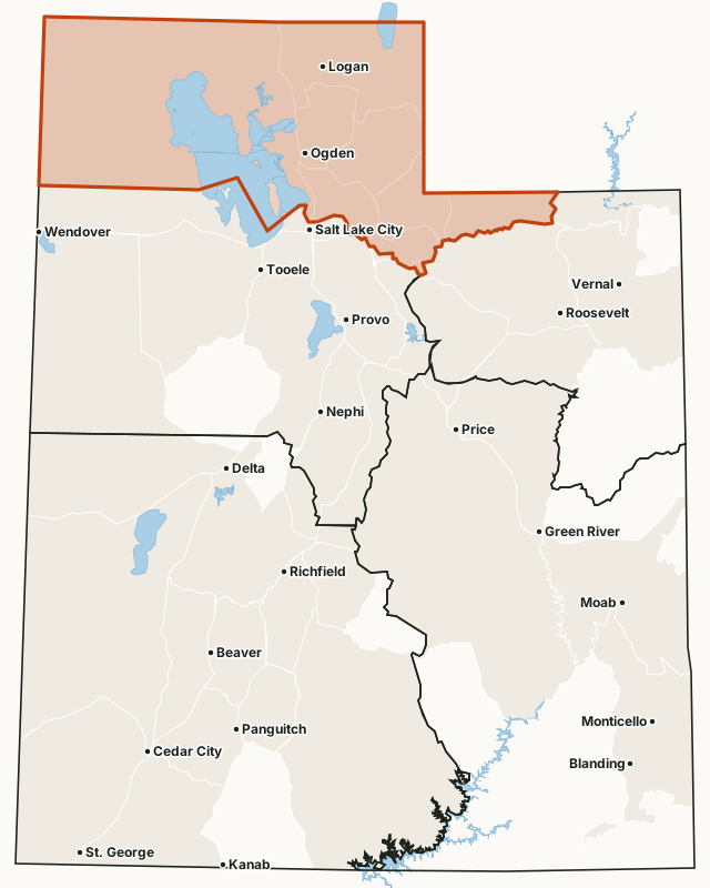
Which hunt units are in the Northern Region?
Every unit below lies mostly in the Northern Region by DWR's region map, with DWR's latest harvest and the public land share measured inside it. Utah draws a separate map of units for each species and hunt type, so the same ground appears under several units.
General-season deer units
| Unit | Square miles | Public land | Bucks harvested (DWR) | Hunters afield |
|---|---|---|---|---|
| Box Elder | 8,973 | 36% | 1,123 (2025) | 3,870 |
| Cache | 1,832 | 47.1% | 899 (2025) | 3,596 |
| North Slope | 1,224 | 89% | 685 (2025) | 2,227 |
| Ogden | 633 | 25.5% | 566 (2025) | 1,790 |
| Chalk Creek | 617 | 10.1% | 532 (2025) | 1,611 |
| East Canyon | 631 | 18.7% | 325 (2025) | 1,380 |
| Morgan-South Rich | 930 | 14.1% | 251 (2025) | 1,114 |
| Kamas | 343 | 59.1% | 199 (2025) | 911 |
Limited-entry deer units
| Unit | Square miles | Public land | Bucks harvested (DWR) | Permits |
|---|---|---|---|---|
| Cache, Crawford Mountain | 129 | 40.7% | 8 (2025) | 8 |
| Antelope Island | 44 | 1% | 1 (2025) | 1 |
Limited-entry bull elk units
| Unit | Square miles | Public land | Bulls harvested (DWR) | Permits |
|---|---|---|---|---|
| Cache, South | 431 | 78.2% | 29 (2025) | 44 |
| Cache, North | 239 | 73.5% | 25 (2025) | 52 |
| Cache, Meadowville | 285 | 54.8% | 21 (2025) | 51 |
| Box Elder, Grouse Creek | 876 | 50.5% | 19 (2025) | 22 |
| Box Elder, Pilot Mountain | 1,339 | 57.2% | 9 (2025) | 15 |
Limited-entry buck pronghorn units
| Unit | Square miles | Public land | Bucks harvested (DWR) | Permits |
|---|---|---|---|---|
| Box Elder, Snowville | 1,353 | 50.6% | 37 (2025) | 50 |
| Box Elder, West | 2,312 | 58.6% | 32 (2025) | 52 |
| North Slope, Summit | 606 | 88.9% | 13 (2025) | 18 |
| Box Elder, Promontory | 1,592 | 12.8% | 12 (2025) | 21 |
| Cache, Rich | 746 | 48% | 6 (2025) | 10 |
Once-in-a-lifetime bull moose units
| Unit | Square miles | Public land | Moose harvested (DWR) | Permits |
|---|---|---|---|---|
| North Slope, Summit | 606 | 88.9% | 24 (2025) | 26 |
| Cache | 1,832 | 47.1% | 16 (2025) | 16 |
| Ogden | 633 | 25.5% | 7 (2025) | 7 |
| East Canyon | 631 | 18.7% | 5 (2025) | 5 |
| East Canyon, Morgan-Summit | 378 | 7.1% | 5 (2025) | 5 |
| Morgan-South Rich | 930 | 14.1% | 5 (2025) | 6 |
| Kamas | 343 | 59.1% | 4 (2025) | 5 |
| Chalk Creek | 617 | 10.1% | 3 (2025) | 3 |
Once-in-a-lifetime Rocky Mountain bighorn sheep units
| Unit | Square miles | Public land | Sheep harvested (DWR) | Permits |
|---|---|---|---|---|
| North Slope, Summit/West Daggett | 999 | 87.6% | 4 (2025) | 4 |
| Antelope Island | 44 | 1% | 1 (2025) | 1 |
Once-in-a-lifetime mountain goat units
| Unit | Square miles | Public land | Goats harvested (DWR) | Permits |
|---|---|---|---|---|
| Ogden, Willard Peak | 179 | 32% | 1 (2025) | 1 |
Once-in-a-lifetime bison units
| Unit | Square miles | Public land | Bison harvested (DWR) | Permits |
|---|---|---|---|---|
| Antelope Island | 44 | 1% | 2 (2025) | 2 |
Harvest: DWR harvest reports, 2013 to 2025. Public land measured by FilledTag from UGRC's statewide land ownership map (last edited 2023). Region: DWR regional boundaries.
How much of the Northern Region is public land?
34.1% of the region is public land open to hunting, the largest share BLM (1,249,413 acres). 187 acres are tribal land. 209,795 acres are military land, closed to the public.
| Manager | Acres | Share of the Northern Region |
|---|---|---|
| BLM | 1,249,413 | 15.4% |
| National forest | 1,093,294 | 13.4% |
| State sovereign land (lake and river beds) | 1,067,942 | 13.1% |
| State trust land (SITLA) | 241,003 | 3% |
| Military land (closed) | 209,795 | 2.6% |
| DWR wildlife land | 113,044 | 1.4% |
| National wildlife refuge | 73,927 | 0.9% |
| State park (park rules) | 44,022 | 0.5% |
| Bureau of Reclamation | 2,526 | under 0.1% |
| National park or monument (NPS, no hunting) | 2,215 | under 0.1% |
| Tribal land (tribe's rules) | 187 | under 0.1% |
| Other public land (highways, other state land) | 120 | under 0.1% |
| Private and other land not shown | 4,031,723 | 49.6% |
What wildlife management areas are in the Northern Region?
DWR lists 27 wildlife and waterfowl management areas in the region, from Farmington Bay WMA (28,699 acres) down to Stoddard Slough WMA (21 acres). 19 of them have a page here.
- Farmington Bay WMA: 28,699 acres
- Locomotive Springs WMA: 18,459 acres
- Middle Fork WMA: 16,725 acres
- Ogden Bay WMA: 16,656 acres
- Henefer-Echo WMA: 14,939 acres
- Hardware WMA: 14,466 acres
- Willard Spur WMA: 13,441 acres
- Public Shooting Grounds WMA: 13,356 acres
- Harold Crane WMA: 9,848 acres
- Cinnamon Creek WMA: 8,148 acres
- Salt Creek WMA: 6,205 acres
- Millville-Providence WMA: 5,874 acres
- East Canyon WMA: 5,862 acres
- Brigham Face WMA: 4,595 acres
- Woodruff Co-Op WMA: 2,911 acres
- Howard Slough WMA: 2,546 acres
- Richmond WMA: 2,048 acres
- Kamas WMA: 1,061 acres
- Coldwater Canyon WMA: 1,043 acres
- Swan Creek WMA: 699 acres
- Causey WMA: 646 acres
- Weber Face WMA: 563 acres
- Bud Phelps WMA: 272 acres
- East Fork Little Bear WMA: 233 acres
- Bear River Bottoms WMA: 48 acres
- Rockport WMA: 40 acres
- Stoddard Slough WMA: 21 acres
DWR's Walk-In Access program has 21 active hunting properties in the region, about 10,251 acres of private land open to walk-in hunting under each property's rules (DWR Walk-In Access).
Get a Utah hunt plan when they open
Hunt plans for Utah are coming. Join the list and you'll hear first. The first 50 hunters in each new state get their plan free.
Until then, the free FilledTag app for iPhone has a map that works in every state, Utah included.
Sources: DWR harvest reports, 2013 to 2025; UGRC's statewide land ownership map (last edited 2023); DWR public access properties (WMAs); DWR Walk-In Access properties (December 17, 2025); DWR regional boundaries. FilledTag is not part of the Utah Division of Wildlife Resources.
Utah hunting units Central Region Northeastern Region Southeastern Region Southern Region