Scotch Creek Wildlife Area: hunting, units and access
The Scotch Creek Wildlife Area is 26,143 acres of land managed by WDFW in Region 2, in 7 units, inside GMUs 233, 204, 209 and 215, measured from WDFW's boundary. The busiest elk unit it touches is GMU 204, where WDFW reports 35 elk taken in 2025.
Data updated October 2026. Area facts: WDFW's page for the Scotch Creek Wildlife Area, read 2026-10-18, and WDFW's facility data. Harvest: WDFW reports to 2025.
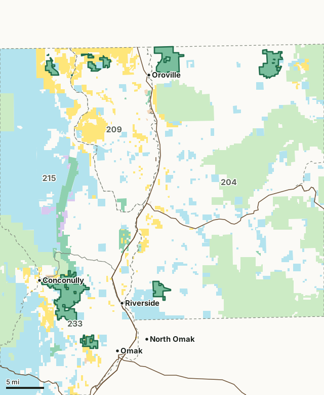
National forestBLMDNR state trust landWDFW landNational wildlife refuge (refuge rules; not counted)Bureau of ReclamationOther public (parks, county, city, other agencies)Scotch Creek Wildlife AreaGMU lineLake or riverHighway
| Size | 26,143 acres (WDFW boundary, measured by FilledTag) |
|---|---|
| WDFW region | Region 2, North Central Washington |
| GMUs | GMU 233, GMU 204, GMU 209, GMU 215 |
| Units | 7 |
| Roads and trails | 79 miles |
| Parking areas | 19 |
| Campgrounds | 1 |
| Boat ramps | 3 |
| Nearest towns | Conconully (next to it), Oroville (next to it) and Omak (3 mi) |
What is the Scotch Creek Wildlife Area like?
The Scotch Creek Wildlife Area encompasses 23,980 acres and is located in central Okanogan County. and is split into seven management units. It was established in 1991 as a site to support recovery of the region's sharp-tailed grouse population. The wildlife area's lands consist primarily of shrubsteppe habitat, with riparian, conifer, ponderosa pine, and aspen habitat mixed into the landscape as well. A variety of wildlife species are present, including white-tailed deer, mule deer, bighorn sheep, California quail, hawks, woodpeckers and other cavity-nesting birds, and many species of songbirds. By actively managing lands, restoring habitats, and preserving wild places, the department serves as stewards for Washington's natural places, protecting the state's land and water for its human and wildlife populations.
In WDFW's words, from WDFW's Scotch Creek Wildlife Area page.
What units make up the Scotch Creek Wildlife Area?
WDFW manages the area as 7 units. The largest is Scotch Creek at 10,502 acres.
| Unit | Acres | GMUs | Parking areas | Campgrounds | Hunting blinds |
|---|---|---|---|---|---|
| Scotch Creek | 10,502 | 233 | 5 | 0 | 0 |
| Charles And Mary Eder | 5,536 | 204 | 1 | 0 | 0 |
| Chesaw | 4,269 | 204 | 2 | 0 | 0 |
| Tunk Valley | 1,764 | 204 | 2 | 0 | 0 |
| Ellemehan | 1,514 | 209 | 3 | 0 | 0 |
| Pogue Mountain | 1,401 | 233 | 4 | 1 | 0 |
| Similkameen-Chopaka | 1,158 | 215 | 3 | 0 | 0 |
Unit outlines and facilities: WDFW wildlife area and unit boundaries. Acres measured by FilledTag.
WDFW's notes for each unit
Scotch Creek: All lands in Washington are CLOSED to the taking of sharp-tailed grouse including all Scotch Creek Wildlife Area Units. The WDFW is very concerned with the accidental take of this protected species. Again, know your target before pulling the trigger. WDFW
Charles And Mary Eder: The area is managed as a quality hunting area thereby limiting the number of hunters that can access the property during the respective deer seasons. Permits are drawn each August for modern firearm, archery, muzzleloader, late whitetail, and youth permits. The area is open for public use at all other times of the year, and hunting for upland birds and small game are open per pamphlet regulations. WDFW
Chesaw: All lands in Washington State are CLOSED to the taking of sharp-tailed grouse including all Scotch Creek Wildlife Area Units. The WDFW is very concerned with the accidental take of this protected species. Again, know your target before pulling the trigger. WDFW
Tunk Valley: All lands in Washington State are closed to the taking of sharp-tailed grouse including all Scotch Creek Wildlife Area Units. WDFW
Ellemehan: Access can be difficult so successful hunters should expect a long pack out. WDFW
Pogue Mountain: Opportunities for hunting game animals include mule deer, white-tailed deer, quail, dusky and ruffed grouse, black bear, cougar, and bobcat. WDFW
Similkameen-Chopaka: This unit is known for trophy white-tailed buck deer. Other big game animals include bighorn sheep and mountain goats on the slopes of Chopaka Mountain, black bear and cougar. Ruffed grouse use the riparian areas, and upland birds include ring-necked pheasant, gray partridge, California quail, chukar and mourning dove. Each spring, the ponds and oxbows are filled with Canada geese, dabblers and diving ducks of all kinds and trumpeter swans. The short meadow grass fields are forage for geese and waterfowl. WDFW
How many elk and deer are taken in the GMUs around the Scotch Creek Wildlife Area?
WDFW reports harvest by GMU, not by wildlife area. These are the whole GMUs the area lies in:
| GMU | Wildlife area acres in it | Elk taken, 2025 | Deer taken, 2025 | Bears taken, 2025 |
|---|---|---|---|---|
| GMU 233 Pogue | 11,903 | 2 | 150 | 6 |
| GMU 204 Okanogan East | 11,569 | 35 | 780 | 42 |
| GMU 209 Wannacut | 1,510 | 2 | 130 | 5 |
| GMU 215 Sinlahekin | 1,162 | 0 | 219 | 19 |
Harvest: WDFW Game Harvest Reports (GMU, 2025). Wildlife area acres in each GMU measured by FilledTag from WDFW's boundaries.
How do you get to the Scotch Creek Wildlife Area?
Highways within 5 miles: US 97, SR 20, SR 215 and SR 155. Nearest towns: Conconully (next to it), Oroville (next to it), Omak (3 miles) and Okanogan (4 miles).
Questions hunters ask
Do you need a pass to park at the Scotch Creek Wildlife Area?
Yes. Parking on WDFW land needs the Vehicle Access Pass that comes with most annual hunting and fishing licenses, or a Discover Pass, displayed where it can be seen from outside the vehicle (WDFW pamphlet, page 72).
Which GMUs is the Scotch Creek Wildlife Area in?
GMU 233 Pogue (11,903 acres), GMU 204 Okanogan East (11,569 acres), GMU 209 Wannacut (1,510 acres) and GMU 215 Sinlahekin (1,162 acres), by WDFW's boundaries. Seasons follow each GMU's rules.
Can you camp on the Scotch Creek Wildlife Area?
WDFW's facility data lists 1 campground on the Scotch Creek Wildlife Area. Follow the posted rules and WDFW's public conduct rules.
Get a Washington hunt plan when they open
Hunt plans for Washington are coming. Join the list and you'll hear first. The first 50 hunters in each new state get their plan free.
Until then, the free FilledTag app for iPhone has a map that works in every state, Washington included.
Where these facts come from
- Area description, rules and access notes: WDFW, Scotch Creek Wildlife Area.
- Boundary, units and facilities: WDFW wildlife area and unit boundaries. Surrounding public land: WA DNR Major Public Lands (non-DNR) and WA DNR Managed Land Parcels, read 2026-10.
- GMU harvest: WDFW Game Harvest Reports. Parking passes: WDFW 2026 Big Game Hunting Seasons and Regulations, page 72.
FilledTag is not part of Washington Department of Fish and Wildlife. Numbers are copied from WDFW and the State of Washington, or measured from their maps; nothing on this page is estimated by FilledTag. WDFW's regulations are the final word on every rule.
Washington hunting Region 2 GMU 233 elk GMU 204 elk GMU 215 elk