Sunnyside-Snake River Wildlife Area: hunting, units and access
The Sunnyside-Snake River Wildlife Area is 22,002 acres of land managed by WDFW in Region 3, in 15 units, inside GMUs 372, 379, 373 and 381, measured from WDFW's boundary. The busiest elk unit it touches is GMU 372, where WDFW reports 41 elk taken in 2025.
Data updated October 2026. Area facts: WDFW's page for the Sunnyside-Snake River Wildlife Area, read 2026-10-18, and WDFW's facility data. Harvest: WDFW reports to 2025.
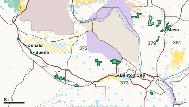
BLMDNR state trust landWDFW landNational wildlife refuge (refuge rules; not counted)Bureau of ReclamationMilitary land (restricted)Other public (parks, county, city, other agencies)Sunnyside-Snake River Wildlife AreaGMU lineLake or riverHighway
| Size | 22,002 acres (WDFW boundary, measured by FilledTag) |
|---|---|
| WDFW region | Region 3, South Central Washington |
| GMUs | GMU 372, GMU 379, GMU 373, GMU 381 |
| Units | 15 |
| Roads and trails | 121 miles |
| Parking areas | 38 |
| Hunting blinds | 13 (3 accessible) |
| Boat ramps | 6 |
| Nearest towns | Mesa (next to it), Zillah (next to it) and Benton City (next to it) |
What is the Sunnyside-Snake River Wildlife Area like?
The Sunnyside-Snake River Wildlife Area covers approximately 21,500 acres located in Franklin, Benton, and Yakima counties. Acquisitions began in the late 1940s to protect and enhance habitat and provide public recreation. Some of the lands also help meet mitigation goals for Bonneville Power Administration and U.S. Army Corps of Engineers construction projects to address habitat losses for a variety of wildlife species. Some of the management units are owned by the Bureau of Reclamation, but are managed as part of the wildlife area.
In WDFW's words, from WDFW's Sunnyside-Snake River Wildlife Area page.
What units make up the Sunnyside-Snake River Wildlife Area?
WDFW manages the area as 15 units. The largest is Bailie at 3,927 acres.
| Unit | Acres | GMUs | Parking areas | Campgrounds | Hunting blinds |
|---|---|---|---|---|---|
| Bailie | 3,927 | 379 | 2 | 0 | 4 |
| Rattlesnake Slope | 3,592 | 372 | 1 | 0 | 0 |
| Sunnyside | 2,879 | 372, 373 | 6 | 0 | 4 |
| Thornton | 2,114 | 372 | 2 | 0 | 0 |
| Thompson Seeps | 1,808 | 379 | 1 | 0 | 0 |
| Windmill Ranch | 1,767 | 379 | 2 | 0 | 2 |
| Esquatzel Coulee | 1,677 | 381 | 2 | 0 | 0 |
| I-82 Ponds | 1,188 | 372 | 11 | 0 | 0 |
| Byron | 1,007 | 373 | 2 | 0 | 0 |
| Mesa Lake | 720 | 379 | 2 | 0 | 3 |
| Hope Valley | 508 | 379 | 2 | 0 | 0 |
| Vance-Ferry Road | 159 | 373 | 1 | 0 | 0 |
| Glover | 51 | 372 | 1 | 0 | 0 |
| Whitstran | 40 | 372 | 1 | 0 | 0 |
| Benton City | 20 | 372 | 2 | 0 | 0 |
Unit outlines and facilities: WDFW wildlife area and unit boundaries. Acres measured by FilledTag.
WDFW's notes for each unit
Bailie: Access is only allowed from 2 parking lots. There is a 5 vehicle limit for each parking lot. All visitors must register on site when arriving, and report their activity before leaving. WDFW
Rattlesnake Slope: Chukar, deer, and elk are the most likely species to be hunted. WDFW
Sunnyside: A Game Reserve is established on this unit (WAC 220-411-190). Game Reserves are CLOSED AREAS where hunting and trapping for all wild animals and wild birds is prohibited (RCW 77.12.047). WDFW
Thornton: The unit is a popular hunting area for deer and is one of the best units of the Sunnyside-Snake River Wildlife Area for the public to hunt elk. WDFW
Thompson Seeps: Upland bird, small game, deer and waterfowl hunting occur on the unit. WDFW
Windmill Ranch: It is unlawful to possess shot (either in shotshells or as loose shot for muzzleloading) other than nontoxic shot for any purpose on this unit (WAC 220-414-040). WDFW
Esquatzel Coulee: This unit is popular for upland and small game hunting. Hunters will find deer, Eurasian collared dove, mourning dove, quail, and pheasant. WDFW
I-82 Ponds: This unit offers opportunities to hunt deer, waterfowl, Eurasian collared dove, mourning dove, quail, pheasant, and small game. WDFW
How many elk and deer are taken in the GMUs around the Sunnyside-Snake River Wildlife Area?
WDFW reports harvest by GMU, not by wildlife area. These are the whole GMUs the area lies in:
| GMU | Wildlife area acres in it | Elk taken, 2025 | Deer taken, 2025 | Bears taken, 2025 |
|---|---|---|---|---|
| GMU 372 Rattlesnake Hills | 9,735 | 41 | 31 | 0 |
| GMU 379 Ringold | 8,730 | 22 | 69 | 0 |
| GMU 373 Horse Heaven | 1,722 | 0 | 146 | 0 |
| GMU 381 Kahlotus | 1,677 | 27 | 413 | 0 |
Harvest: WDFW Game Harvest Reports (GMU, 2025). Wildlife area acres in each GMU measured by FilledTag from WDFW's boundaries.
How do you get to the Sunnyside-Snake River Wildlife Area?
Highways within 5 miles: I-82, US 12, US 395, US 97 and SR 22. Nearest towns: Mesa (next to it), Zillah (next to it), Benton City (next to it) and Mabton (next to it).
Questions hunters ask
Do you need a pass to park at the Sunnyside-Snake River Wildlife Area?
Yes. Parking on WDFW land needs the Vehicle Access Pass that comes with most annual hunting and fishing licenses, or a Discover Pass, displayed where it can be seen from outside the vehicle (WDFW pamphlet, page 72).
Which GMUs is the Sunnyside-Snake River Wildlife Area in?
GMU 372 Rattlesnake Hills (9,735 acres), GMU 379 Ringold (8,730 acres), GMU 373 Horse Heaven (1,722 acres) and GMU 381 Kahlotus (1,677 acres), by WDFW's boundaries. Seasons follow each GMU's rules.
Can you camp on the Sunnyside-Snake River Wildlife Area?
WDFW's facility data lists no developed campground on the Sunnyside-Snake River Wildlife Area. Camping on WDFW land follows WDFW's public conduct rules and any closures posted for the area; check WDFW's page before planning a camp.
Get a Washington hunt plan when they open
Hunt plans for Washington are coming. Join the list and you'll hear first. The first 50 hunters in each new state get their plan free.
Until then, the free FilledTag app for iPhone has a map that works in every state, Washington included.
Where these facts come from
- Area description, rules and access notes: WDFW, Sunnyside-Snake River Wildlife Area.
- Boundary, units and facilities: WDFW wildlife area and unit boundaries. Surrounding public land: WA DNR Major Public Lands (non-DNR) and WA DNR Managed Land Parcels, read 2026-10.
- GMU harvest: WDFW Game Harvest Reports. Parking passes: WDFW 2026 Big Game Hunting Seasons and Regulations, page 72.
FilledTag is not part of Washington Department of Fish and Wildlife. Numbers are copied from WDFW and the State of Washington, or measured from their maps; nothing on this page is estimated by FilledTag. WDFW's regulations are the final word on every rule.
Washington hunting Region 3 GMU 372 elk GMU 379 elk GMU 381 elk