Wenas Wildlife Area: hunting, units and access
The Wenas Wildlife Area is 106,758 acres of land managed by WDFW in Region 3, inside GMUs 342 and 340, measured from WDFW's boundary. The busiest elk unit it touches is GMU 342, where WDFW reports 131 elk taken in 2025.
Data updated October 2026. Area facts: WDFW's page for the Wenas Wildlife Area, read 2026-10-18, and WDFW's facility data. Harvest: WDFW reports to 2025.
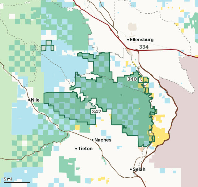
National forestBLMDNR state trust landWDFW landBureau of ReclamationMilitary land (restricted)Other public (parks, county, city, other agencies)Wenas Wildlife AreaGMU lineLake or riverHighway
| Size | 106,758 acres (WDFW boundary, measured by FilledTag); WDFW's page says 106,742 acres |
|---|---|
| WDFW region | Region 3, South Central Washington |
| GMUs | GMU 342, GMU 340 |
| Roads and trails | 404 miles, 211 of them Green Dot roads |
| Parking areas | 13 |
| Boat ramps | 2 |
| Nearest towns | Naches (3 mi), Ellensburg (4 mi) and Selah (5 mi) |
What is the Wenas Wildlife Area like?
The Wenas Wildlife Area has a variety of recreation opportunities. Big game hunting is popular, multiple trails offer hiking opportunities, and the upper Wenas Valley is considered an Important Bird Area by the Audubon Society. Much of the wildlife area is dominated by shrubsteppe vegetation; some forest vegetation types exist at higher elevations and in riparian areas. Wildlife use is diverse, including elk, deer, bighorn sheep, turkey, chukar, quail, and a myriad of small mammals, Neotropical/upland birds, raptors, and reptiles. Part of this unit is funded by the Bonneville Power Administration and managed for preservation of fish and wildlife resources to mitigate for habitat losses associated with Grand Coulee, McNary and John Day hydroelectric dams.
The Wenas Wildlife Area is located southwest of Ellensburg and northwest of Selah, in both Yakima and Kittitas counties. Access to the south portion of the unit is from North Wenas Road (via Selah or Naches), and access to the north portion of the unit is from Umtanum Road (via Ellensburg).
In WDFW's words, from WDFW's Wenas Wildlife Area page.
What are WDFW's hunting rules on the Wenas Wildlife Area?
WDFW's hunting notes for the area, in its words:
- Big game hunting, for elk, deer, and bighorn sheep, is popular on this wildlife area, as is upland game bird hunting. WDFW also releases pheasants on this unit for hunting.
From WDFW's Wenas Wildlife Area page. Seasons and legal animals follow the GMU the ground is in.
How many elk and deer are taken in the GMUs around the Wenas Wildlife Area?
WDFW reports harvest by GMU, not by wildlife area. These are the whole GMUs the area lies in:
| GMU | Wildlife area acres in it | Elk taken, 2025 | Deer taken, 2025 | Bears taken, 2025 |
|---|---|---|---|---|
| GMU 342 Umtanum | 85,842 | 131 | 98 | 0 |
| GMU 340 Manastash | 20,911 | 124 | 79 | 5 |
Harvest: WDFW Game Harvest Reports (GMU, 2025). Wildlife area acres in each GMU measured by FilledTag from WDFW's boundaries.
How do you get to the Wenas Wildlife Area?
Highways within 5 miles: US 97, I-82, SR 821, I-90 and US 12. Nearest towns: Naches (3 miles), Ellensburg (4 miles), Selah (5 miles) and Tieton (5 miles).
WDFW's access notes:
- Motorized vehicles must stay on designated Green Dot roads. Please follow Green Dot Road Management regulations and use a Green Dot map of the area for reference.
- Campfires are prohibited from April 15 through Oct. 15.
- The Cleman Mountain is 30,000 acres of land closed to all public access from early Dec. through April 30.
- 4 graveled parking areas: 2 at Sheep Company entrance (2nd area for horse trailer parking), 1 at Buffalo Road entrance, and 1 at Umtanum Falls trailhead
Questions hunters ask
Do you need a pass to park at the Wenas Wildlife Area?
Yes. Parking on WDFW land needs the Vehicle Access Pass that comes with most annual hunting and fishing licenses, or a Discover Pass, displayed where it can be seen from outside the vehicle (WDFW pamphlet, page 72).
Which GMUs is the Wenas Wildlife Area in?
GMU 342 Umtanum (85,842 acres) and GMU 340 Manastash (20,911 acres), by WDFW's boundaries. Seasons follow each GMU's rules.
Can you camp on the Wenas Wildlife Area?
WDFW's facility data lists no developed campground on the Wenas Wildlife Area. Camping on WDFW land follows WDFW's public conduct rules and any closures posted for the area; check WDFW's page before planning a camp.
Can you drive on the Wenas Wildlife Area?
On marked roads. WDFW's data counts 211 miles of Green Dot roads here, the roads open to motor vehicles under WDFW's Green Dot system, out of 404 miles of roads and trails.
Get a Washington hunt plan when they open
Hunt plans for Washington are coming. Join the list and you'll hear first. The first 50 hunters in each new state get their plan free.
Until then, the free FilledTag app for iPhone has a map that works in every state, Washington included.
Where these facts come from
- Area description, rules and access notes: WDFW, Wenas Wildlife Area.
- Boundary, units and facilities: WDFW wildlife area and unit boundaries. Surrounding public land: WA DNR Major Public Lands (non-DNR) and WA DNR Managed Land Parcels, read 2026-10.
- GMU harvest: WDFW Game Harvest Reports. Parking passes: WDFW 2026 Big Game Hunting Seasons and Regulations, page 72.
FilledTag is not part of Washington Department of Fish and Wildlife. Numbers are copied from WDFW and the State of Washington, or measured from their maps; nothing on this page is estimated by FilledTag. WDFW's regulations are the final word on every rule.