Tyler County, West Virginia: deer, bear and turkey hunting, harvest and public land
WVDNR counted 982 deer taken in Tyler County in 2025: 417 bucks in the buck firearms season, 327 antlerless deer, 214 by bow and crossbow, 21 by muzzleloader and 3 in the Mountaineer Heritage season. Hunters also took 4 bears and 199 spring gobblers here. 2.3% of the county is public land, the largest share WVDNR land (WMAs, state forests, parks) (3,242 acres).
Data updated October 2026. Harvest: WVDNR 2025 Big Game Bulletin. Seasons: WVDNR 2026-2027 Hunting and Trapping Regulations Summary. Land: PAD-US 4.1.
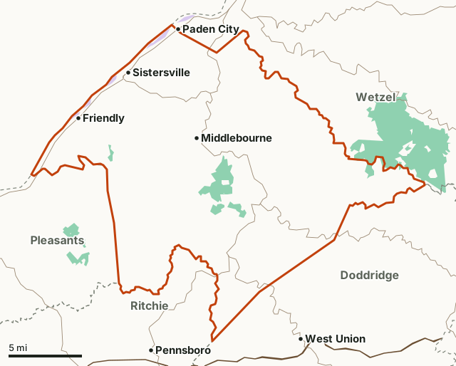
WVDNR land (WMAs, state forests, parks)National wildlife refugeTyler CountyNeighboring countiesHighway
| Size | 261 square miles |
|---|---|
| Public land | 2.3% (3,803 acres) |
| Wildlife management areas | The Jug WMA, Conaway Run Lake WMA, Lewis Wetzel WMA and Buffalo Run WMA |
| Deer taken, 2025 | 982 (563 antlered, 369 does) |
| Bucks, buck firearms season 2025 | 417 |
| Deer taken per square mile of habitat, 2025 | 3.9 (WVDNR; 252 square miles of deer habitat) |
| Bears taken, 2025 | 4 |
| Spring gobblers, 2025 | 199 |
| Buck firearms season, 2026 | November 23 to December 6 |
How many deer are taken in Tyler County?
WVDNR's bulletin gives Tyler County's deer by season for five years. In 2025 the buck firearms season produced 417 bucks, against 734 in 2024.
| Year | Bucks, buck firearms season | Antlerless season | Archery (bow) | Crossbow | Muzzleloader |
|---|---|---|---|---|---|
| 2025 | 417 | 327 | 103 | 111 | 21 |
| 2024 | 734 | 648 | 131 | 234 | 63 |
| 2023 | 687 | 559 | 111 | 166 | 60 |
| 2022 | 900 | 728 | 139 | 232 | 69 |
| 2021 | 505 | 489 | 104 | 171 | 43 |
By type in 2025: 563 antlered deer, 28 with antlers under three inches, 19 button bucks, 369 does and 3 with antlers shed. That comes to 3.9 deer for every square mile of deer habitat, by WVDNR's own measure (1.65 bucks and 1.3 antlerless deer per square mile).
Source: WVDNR 2025 Big Game Bulletin, Tables 15 to 22.
How many bears are taken in Tyler County?
WVDNR counted 4 bears in Tyler County in 2025. By season: 1 bow and crossbow, 0 September and October gun, 3 buck gun, 0 December firearms and 0 Mountaineer Heritage.
| Year | Bears |
|---|---|
| 2025 | 4 |
| 2024 | 1 |
| 2023 | 1 |
| 2022 | 3 |
| 2021 | 3 |
Source: WVDNR 2025 Big Game Bulletin, Tables 1 and 3.
How many turkeys are taken in Tyler County?
| Year | Spring gobblers | Fall turkeys |
|---|---|---|
| 2025 | 199 | 6 |
| 2024 | 237 | 15 |
| 2023 | 192 | 14 |
| 2022 | 138 | 9 |
| 2021 | 157 | 2 |
Source: WVDNR 2025 Big Game Bulletin, Tables 7 and 9.
When are the 2026-27 seasons in Tyler County?
| Season | Dates, 2026-27 |
|---|---|
| Deer, archery and crossbow | September 26 to December 31 |
| Deer, youth, Class Q and Class XS (antlerless) | October 17 to 18, and December 26 to 27 |
| Deer, antlerless (selected counties) | October 22 to 25, November 23 to December 6, December 10 to 13, and December 28 to 31 |
| Deer, buck firearms | November 23 to December 6 |
| Deer, muzzleloader | December 14 to 20 |
| Deer, bear and turkey, Mountaineer Heritage (private land in selected counties) | January 14 to 17, 2027 |
| Bear, archery and crossbow | September 26 to December 31 |
| Bear, firearms (selected counties) | August 29 to September 7; September 19 to 25; October 3 to 9; October 22 to 25; November 23 to December 6; December 7 to 31 |
| Turkey, fall | October 10 to 18, with split seasons in selected counties |
| Turkey, spring (bearded only) | April 19 to May 23, 2027 |
Source: WVDNR 2026-2027 Hunting and Trapping Regulations Summary. Antlerless deer, bear firearms and fall turkey seasons are open only in some counties or parts of counties; WVDNR's regulations map them.
How much public land is in Tyler County?
2.3% of Tyler County is public land: 3,803 of its 166,884 acres. The largest share is WVDNR land (WMAs, state forests, parks), 3,242 acres.
| Manager | Acres | Share of Tyler County |
|---|---|---|
| WVDNR land (WMAs, state forests, parks) | 3,242 | 1.9% |
| National wildlife refuge | 561 | 0.3% |
Measured by FilledTag inside the county line from USGS Protected Areas Database of the United States (PAD-US 4.1). Some WMAs are owned by others, such as the Forest Service, and managed by WVDNR.
Wildlife management areas in Tyler County
| WMA | Acres in Tyler County | Owner (WVDNR's record) |
|---|---|---|
| The Jug WMA | 2,095 | WV Division of Natural Resources |
| Conaway Run Lake WMA | 626 | WV Division of Natural Resources |
| Lewis Wetzel WMA | 387 | WV Division of Natural Resources |
| Buffalo Run WMA | 127 | WV Division of Natural Resources |
Source: WVDNR Wildlife Management Areas (served by WVDOT); acres in the county measured by FilledTag.
Which counties border Tyler County?
| County | Public land | Deer, 2025 | Bucks, buck season 2025 | Bears, 2025 |
|---|---|---|---|---|
| Doddridge County | 0.2% | 1,291 | 550 | 6 |
| Pleasants County | 3.2% | 186 | 99 | 0 |
| Ritchie County | 5.6% | 1,365 | 555 | 12 |
| Wetzel County | 6% | 1,374 | 620 | 6 |
Highways crossing Tyler County: WV 18 (31 miles), WV 2 (14 miles), WV 23 (9 miles), WV 180 (4 miles) and WV 74 (2 miles). Towns inside: Sistersville, Middlebourne and Friendly.
Questions hunters ask
How many deer are taken in Tyler County?
WVDNR counted 982 deer in Tyler County in 2025, 417 of them bucks in the buck firearms season. Over 2021 to 2025 the buck season take ran from 417 to 900, the most in 2022.
How many bears are taken in Tyler County?
4 in 2025: 1 by bow and crossbow, 0 in the September and October gun seasons, 3 during buck gun season and 0 in December. The 2021 to 2025 counts were 3 (2021), 3 (2022), 1 (2023), 1 (2024) and 4 (2025) (WVDNR 2025 Big Game Bulletin).
When is buck season in Tyler County in 2026?
The buck firearms season runs November 23 to December 6, 2026, statewide except Logan, McDowell, Mingo and Wyoming counties. Archery and crossbow season runs September 26 to December 31, and muzzleloader December 14 to 20 (WVDNR 2026-2027 Hunting and Trapping Regulations Summary).
How much public land is in Tyler County?
3,803 acres, 2.3% of the county, by PAD-US 4.1. WVDNR's wildlife management areas here: The Jug (2,095 acres in the county), Conaway Run Lake (626 acres in the county), Lewis Wetzel (387 acres in the county) and Buffalo Run (127 acres in the county).
Get a West Virginia hunt plan when they open
Hunt plans for West Virginia are coming. Join the list and you'll hear first. The first 50 hunters in each new state get their plan free.
Until then, the free FilledTag app for iPhone has a map that works in every state, West Virginia included.
Where these numbers come from
- Deer, bear and turkey harvest: WVDNR 2025 Big Game Bulletin.
- Seasons: WVDNR 2026-2027 Hunting and Trapping Regulations Summary.
- County boundary: West Virginia county boundaries (WVDOT). WMAs: WVDNR Wildlife Management Areas (served by WVDOT). Public land: USGS Protected Areas Database of the United States (PAD-US 4.1).
- Highways and towns: U.S. Census Bureau TIGER/Line 2024 primary and secondary roads; U.S. Census Bureau 2024 Gazetteer, places.
FilledTag is not part of the West Virginia Division of Natural Resources. Numbers are copied from WVDNR and federal sources, or measured from their maps; nothing on this page is estimated by FilledTag.
West Virginia hunting Doddridge County Pleasants County Ritchie County Wetzel County