Ferry Bluff State Natural Area: hunting and access
Ferry Bluff State Natural Area is 403 acres of land managed by the Wisconsin DNR in Sauk County, 4 miles from Mazomanie. Hunters registered 6,025 deer in Sauk County in 2025.
Data updated October 2026. Area facts: the DNR's DNR property data, read 2026-10. Harvest: DNR Deer Metrics.
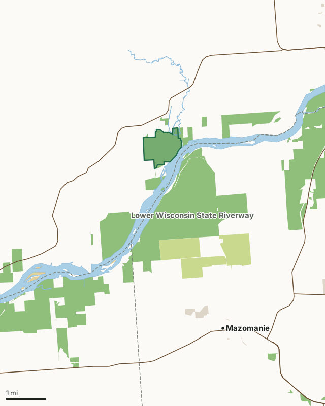
State wildlife areas, forests and other DNR landCounty forestOther federal landOther county, city and regional landFerry Bluff State Natural AreaCounty lineLakeHighway
| Size | 403 acres |
|---|---|
| County | Sauk County |
| Deer Management Unit | Sauk County |
| Public access (DNR) | Open to Hiking, Fishing, Hunting and Trapping |
| DNR property page | Ferry Bluff |
| Nearest towns | Mazomanie (4 mi), Sauk City (4 mi) and Prairie du Sac (5 mi) |
What is Ferry Bluff State Natural Area like?
Ferry Bluff and the adjacent Cactus Bluff tower are more than 300 feet above the confluence of Honey Creek and the Wisconsin River. The sandstone bluffs, capped with dolomite harbors undisturbed open cliff vegetation, prairie remnants, and steep wooded slopes of white and red oaks with basswood, hackberry, elm, hickory, and ironwood. Although the forest on the summit and north-facing slopes are relatively young, the ground layer is rich, with many ferns on the slopes and a diverse spring flora throughout. Prairie species remain especially on the dry south-facing slopes. The moist shaded cliffs contain a diversity of species including many ferns such as fragile and bulbet ferns. Ferry Bluff is the site of a former peregrine falcon eyrie and continues to be an important winter roosting site for bald eagles. The base of the Ferry Bluff also housed a Civil War-era ferryboat landing.
From the intersection of Highways 60 and 12 west of Sauk City, go west on Highway 60 for 4.4 miles then south on Ferry Bluff Road for 1.1 miles to a parking area and canoe landing at the end of the road. A trail leads to the top of Cactus Bluff. The separate southern unit can be accessed via a narrow access lane located near the end of Huerth Road, approximately 0.6 miles east of the junction with Seitz Road. A small informal parking area is available nearby, on the north side of Huerth Road, and is marked with a sign.
In the DNR's words, from its page for the property.
What are the rules on Ferry Bluff State Natural Area?
The DNR's property map lists Ferry Bluff State Natural Area as "Open to Hiking, Fishing, Hunting and Trapping". Hunting follows Wisconsin's statewide seasons and the rules posted on the property.
How many deer are taken around Ferry Bluff State Natural Area?
Ferry Bluff State Natural Area lies in Sauk County. The DNR registered 6,025 deer in Sauk County in 2025, against 5,739 in 2024.
| DMU | Ferry Bluff State Natural Area acres in it | Deer, 2025 | Deer, 2024 | Deer, 2023 |
|---|---|---|---|---|
| Sauk County | 403 | 6,025 | 5,739 | 6,262 |
Harvest for the whole deer management unit, not the property alone: Wisconsin DNR Deer Metrics (registered harvest by deer management unit).
How do you get to Ferry Bluff State Natural Area?
Nearest towns: Mazomanie (4 miles), Sauk City (4 miles), Prairie du Sac (5 miles) and Arena (6 miles). Highways within 5 miles: WI 60, WI 78, US 12 and US 14.
What other public land is near Ferry Bluff State Natural Area?
DNR properties within 10 miles:
- Lower Wisconsin State Riverway: 47,767 acres, next to it
- Great Sauk State Trail: 106 acres, 4.4 miles away
- Black Earth Creek Fishery Area: 441 acres, 5.4 miles away
- Sauk Prairie State Recreation Area: 3,375 acres, 6.4 miles away
- Baraboo Hills State Recreation Area: 1,143 acres, 7.9 miles away
Public land within 3 miles of Ferry Bluff State Natural Area
Counting Ferry Bluff State Natural Area itself, 4,832 of the 24,689 acres within 3 miles of its boundary are public land open to the public (19.6%), by USGS PAD-US 4.1 (fee land open to the public).
| Manager | Acres within 3 miles |
|---|---|
| State wildlife areas, forests and other DNR land | 3,977 |
| County forest | 846 |
| Other federal land | 9 |
Questions hunters ask
Where is Ferry Bluff State Natural Area?
In Sauk County, 4 miles from Mazomanie. The DNR's property page has its maps and parking.
Is Ferry Bluff State Natural Area open to hunting?
Yes. The DNR's property map lists it as "Open to Hiking, Fishing, Hunting and Trapping". Posted refuges or closed areas, where there are any, are marked on site.
Which deer management unit is Ferry Bluff State Natural Area in?
Sauk County.
How much public land is around Ferry Bluff State Natural Area?
4,832 acres within 3 miles of its boundary, Ferry Bluff State Natural Area included, by PAD-US 4.1. The closest other DNR property is Lower Wisconsin State Riverway (next to it).
Get a Wisconsin hunt plan when they open
Hunt plans for Wisconsin are coming. Join the list and you'll hear first. The first 50 hunters in each new state get their plan free.
Until then, the free FilledTag app for iPhone has a map that works in every state, Wisconsin included.
Where these facts come from
- Area description, species, rules and directions: DNR, Ferry Bluff State Natural Area; Wisconsin DNR managed lands open to hunting.
- Boundary and acres: the DNR's map layer above. Surrounding public land: USGS PAD-US 4.1 (fee land open to the public).
- Deer harvest: Wisconsin DNR Deer Metrics (registered harvest by deer management unit).
FilledTag is not part of the Wisconsin Department of Natural Resources. Check the DNR's rules and posted signs before you go.